

Existence by Means of Coexistence: A Stilted Wetland Village Where Tourism Funds Resilience in Hakaluki Haor
Khalifa Sampad's UnIATA '19 entry lifts a haor settlement onto stilts and mounds, using eco-tourism to sustain fishing, craft and migratory birdlife.


Most wetland proposals treat the people who live there as a problem to be managed around the birds. Existence by Means of Coexistence argues the opposite: that the fishers, boatmakers and craftspeople of Hakaluki Haor are part of the ecosystem, and that the right architecture can let them stay, earn more and protect the landscape at the same time. The project's central bet is that community-based tourism, done carefully, can pay for resilience instead of eroding it.
Designed by Khalifa Sampad and recognised with the Organizer's Choice Award at UnIATA '19, the proposal is set in Barlekha, Moulvibazar, where Hakaluki Haor forms a vast seasonal water basin. The region faces recurring floods, poor infrastructure, weak waste management and limited connectivity, while encroachment, climate change and overfishing put pressure on its biodiversity. Sampad's response is not a single building but a settlement strategy: clustered livelihoods, shared civic spaces, raised ground and a network of trails, towers and accommodation for visitors.
Thatch on Stilts, Lifted Clear of a Moving Waterline
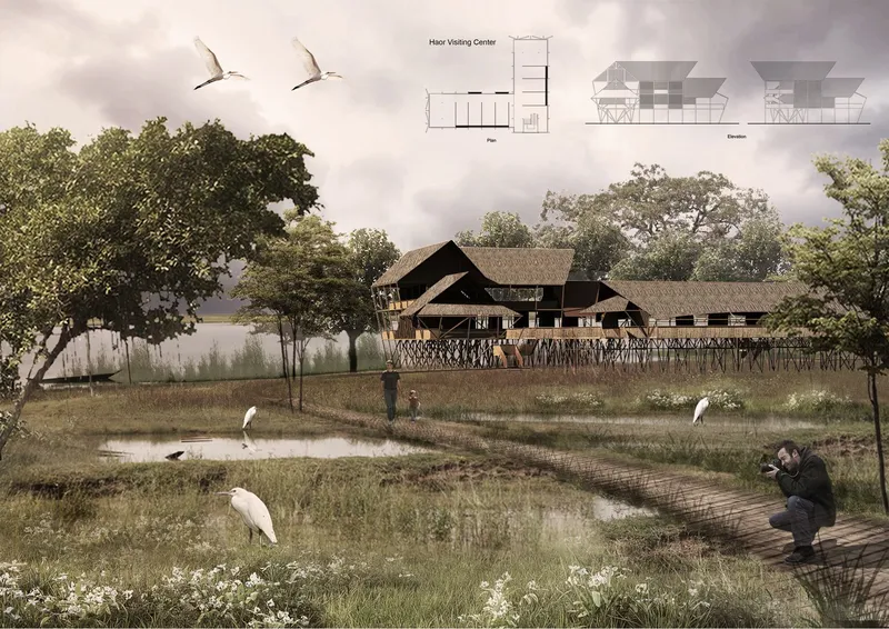
The opening board sets the tone: a thatched building raised on stilts, seen across open water, with egrets in the foreground and a photographer on a boardwalk. The plan and elevation above it confirm that the structure is meant to sit lightly on a site whose edges shift with the seasons. Placement here is deliberate; the project positions settlements in response to the haor's seasonal water levels rather than fighting them with fill.
What makes the image persuasive is the boardwalk. It establishes the visitor as an observer moving along a defined path, close enough to see the birds but held at a distance from the habitat. That relationship, controlled proximity, recurs throughout the scheme.
A School Facing the Monsoon and a Tower Facing the Birds
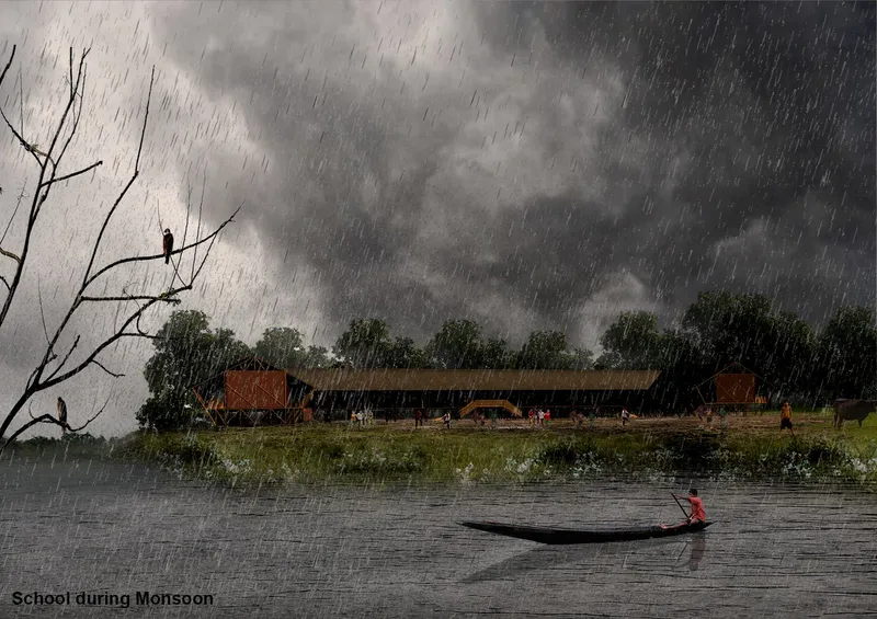
Two programmes anchor the settlement's daily and tourist life. The first is a long, low school on the shoreline, rendered under a dark monsoon storm while a man paddles a narrow boat through the rain. It is an honest image: the building is shown in the conditions it must survive, not in brochure sunshine. Its horizontal profile keeps it low against the wind and reads as a piece of shared infrastructure, consistent with the project's emphasis on communal spaces as sources of unity and resilience.
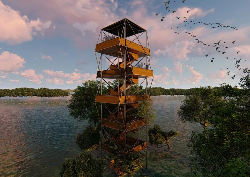
The second is a steel-framed timber observation tower rising from shallow water, its stacked platforms and stairs offering several viewing levels as birds cross a pink dusk sky. Bird-watching towers are one of the project's key tourism instruments, and this one does the work of concentrating visitors vertically, giving them a vantage over the wetland without spreading their footprint across it.
Testing the Village in Contours and Bamboo Sticks
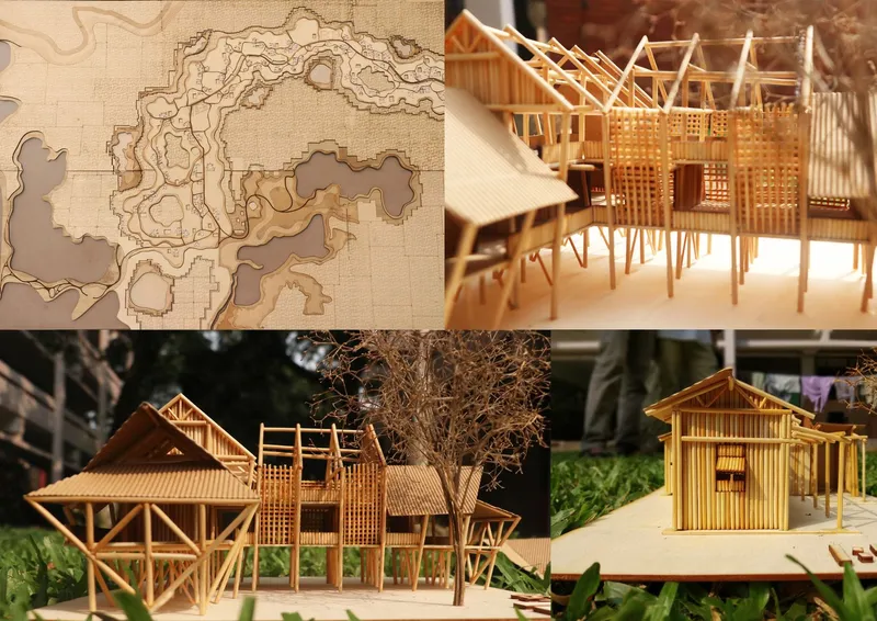
The physical models reveal a designer working with the ground first. A contour site model maps the subtle topography that decides what floods and what stays dry, and beside it, bamboo stick models of stilted, thatched-roof buildings test the vernacular structural logic at small scale. The material choice for the models mirrors the material language of the proposal itself.
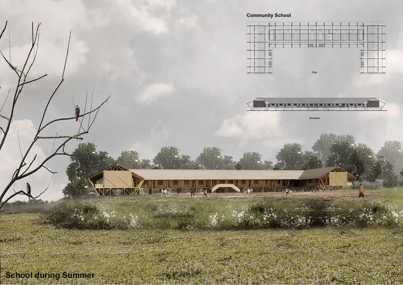
The stilted school appears again behind a flowering meadow, now paired with its plan and elevation, with raptors perched on a bare tree nearby. Repeating the building across dry-season and monsoon views makes a quiet argument: this is architecture designed for two landscapes, the meadow and the flood, that happen to occupy the same ground at different times of year.
Trees as the Threshold Between Visitor and Village
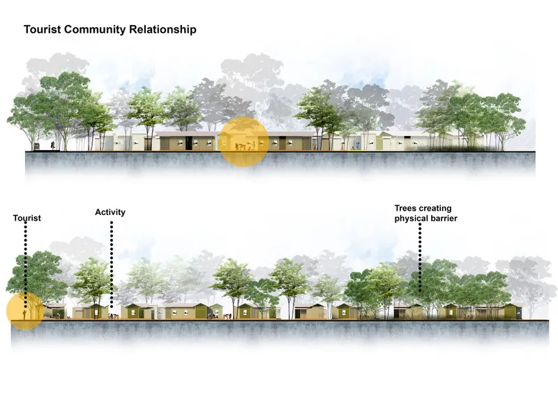
The section drawings carry the project's most thoughtful idea about tourism. Labels for tourist, activity and trees show planting used as a physical barrier, separating visitor routes from the domestic life of village houses. Community-based tourism often fails when residents become exhibits; here, the green buffer gives families a measure of privacy while still letting visitors encounter the fishing, boatmaking and craft activities the scheme clusters to sustain the local economy.
These same tree belts double as resiliency measures. The project lists green buffer zones alongside flood walls and raised platforms, and it treats the region's natural swamp forests as both recreational and ecological assets worth preserving. A single landscape move answers social, environmental and hydrological questions at once.
Digging Ponds to Raise the Ground
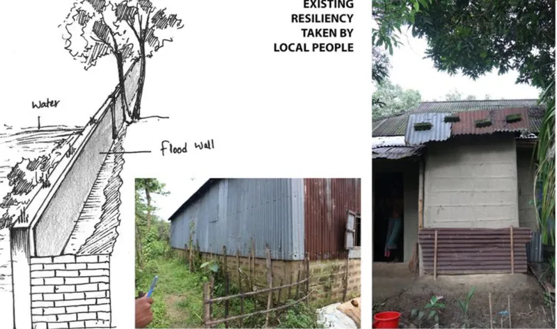
The collage of a sketched flood wall beside photographs of corrugated metal sheds and a mud-walled house with a tin roof grounds the proposal in what already exists. Sampad is not erasing the vernacular; the flood wall is drawn as an addition to houses that people have built for themselves with available materials.
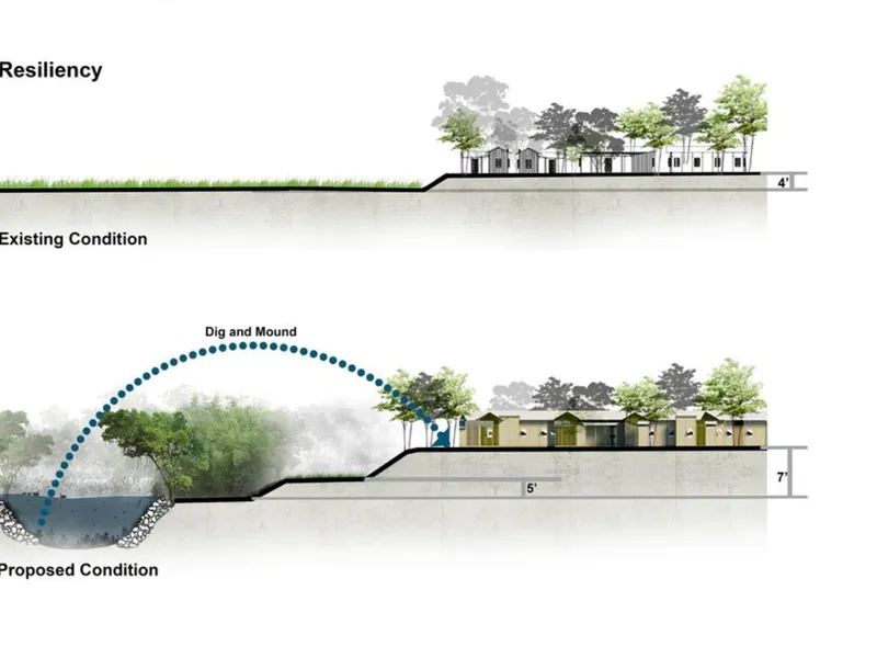
The final section is the clearest piece of strategy in the set. It compares existing flat ground with a proposed dig-and-mound approach: soil excavated to form a pond is used to build up a raised platform, on which houses and trees sit above flood level. The move produces a community pond, a protected building plinth and a planted edge from one act of earthwork. It is cheap, legible and rooted in how settlements across flood-prone regions have long survived, which is exactly why it convinces more than any imported engineering solution would.
Why This Project Matters
Existence by Means of Coexistence is strongest where it is most modest. The dig-and-mound platforms, the tree buffers and the stilted structures are not spectacular, but together they describe a settlement that can absorb the haor's seasonal flooding and continue to function. Adding solar and wind power, community-led waste management and education programmes rounds out a plan aimed at the region's real deficits rather than at an outsider's picture of wilderness.
The broader lesson concerns tourism. Sampad treats eco-tourism not as the goal but as a tool: a supplementary income stream and a way to build awareness about the cultural and ecological heritage of Hakaluki Haor. Trails, bird-watching towers and eco-friendly accommodation are framed as support for fishing, boatmaking and craft rather than replacements for them. For anyone designing in fragile landscapes, the project offers a useful starting position: protect the people, and give them reasons and means to protect the place.
View the Full Project
About the Designers
Designer: Khalifa Sampad
Enter a Design Competition on uni.xyz
uni.xyz runs architecture and design competitions year-round that reward proposals with spatial conviction and real site intelligence.
Project credits: Existence by Means of Coexistence by Khalifa Sampad UnIATA '19 (uni.xyz).


Popular Articles
Popular articles from the community

Temporary Home for Dogs: A Reversed Zoo Rethinks Animal Shelter Architecture
In Bucharest, a sinuous corridor and freed landscape flip the logic of containment, designing a shelter that works to make itself unnecessary.
The Amber Palace Opera: A Geological Fiction Surfaces on Tallinn's Baltic Waterfront
Pierre Brillard reimagines a Baltic legend as a public landscape, opera house, and waterfront promenade rooted in Tallinn's coastal identity.
Singing Woman: An Opera House That Performs Before the Curtain Rises
Ovidiu Cristian Pavel's conceptual opera house translates Estonia's choral identity into a sculpted waterfront landmark facing the Baltic Sea.
Faces of the Soviet Avant-Garde: Turning Moscow's Street Names into an Open-Air Museum
A network of sculptural installations across a Moscow residential district transforms forgotten architect names into spatial encounters with cultural memor

Similar Reads
You might also enjoy these articles

Healing Façade: A Modular Chapel System That Restores Ethiopia's Sacred Forests
Winner of the Eco-Chapel competition, this circular timber façade collects water from air to rebuild soil and reforest degraded Ethiopian landscapes.
Kaffeebühnen: Where Coffee Shop Architecture Becomes a Civic Stage in Vienna
A linear sequence of timber boxes, transparent shells, and open yards turns the Viennese café tradition into a public performance space.
Eco Chapel: A Modular Forest Pavilion That Grows Like the Landscape It Protects
Hexagonal timber modules weave through existing trees, turning a chapel into a living system for prayer, education, and reforestation.


Urban Forest: A Vertical Ecosystem for 5,000 Workers in Singapore's Changi Business Park
Radially stacked pods and layered green decks turn a 7-acre plot into 47 acres of ecological workspace projected for 2040.

Comments (0)
Please login or sign up to add comments
No comments yet. Be the first to comment!