RIFTING
Creating an artificial rift in a natural rift valley.
The most important reason for the team to participate in the competition is the value of the geology that the competition wants to question. Although geology is a very important branch of science, its value is not known much, and the team understood the importance of geology after seeing the subject of this competition. In the name of data collection, firstly, the geology was investigated and the following information was obtained.
Known as ‘geoscience’ or ‘Earth science’, geology is the study of the structure, evolution and dynamics of the Earth and its natural mineral and energy resources. Geology investigates the processes that have shaped the Earth through its 4500 million (approximate) year history and uses the rock record to unravel that history. It is concerned with the real world beyond the laboratory and has direct relevance to the needs of society. Only during the 17th century links were made between sedimentary deposits in the oceans and the strata observable in rock formations. During that time a Scottish farmer and a naturalist, James Hutton recognized that the history of the Earth could be determined by understanding how processes such as erosion and sedimentation work in the present day. His ideas and approach to studying the Earth established geology as a proper science.
Afterwards, geology museums were researched and even the geology museums in the region where the students were located were visited and the following information was learned.
Geological Museums are either stand-alone or often co-located with folklore ones. They usually have rich collections of fossils, palaeontological findings, geological samples, minerals and ores, not only of the region in which they are located, but also from all over domestic and usually from abroad.
Finally, research was conducted on Iceland and Þingvellir National Park, where the project will be located. The following information was obtained.
Þingvellir is situated on the northern shore of Þingvallavatn, the largest natural lake of Iceland. The river Öxará traverses the national park and forms a waterfall at the Almannagjá, called Öxarárfoss. On the lake's northern shore the Silfra fissure is a popular diving and snorkelling tour location.Earthquakes continue every day in Þingvellir, although most are far too minor to be felt. No volcano has gone off in the area in 2000 years, but they are not considered extinct. More eruptions are expected; the question is only as to when. Þingvellir is now a national park in the municipality of Bláskógabyggð in southwestern Iceland, about 40 km northeast of Iceland's capital, Reykjavík. Þingvellir is a site of historical, cultural, and geological significance, and is one of the most popular tourist destinations in Iceland. The park lies in a rift valley that marks the crest of the Mid-Atlantic Ridge and the boundary between the North American and Eurasian tectonic plates. To its south lies Þingvallavatn, the largest natural lake in Iceland. Þingvellir is notable for its unusual tectonic and volcanic environment in a rift valley. The continental drift between the North American and Eurasian Plates can be clearly seen in the cracks or faults which traverse the region, the largest one, Almannagjá, being a veritable canyon. This also causes the often measurable earthquakes in the area. Some of the rifts are full of clear water. One, Nikulásargjá.
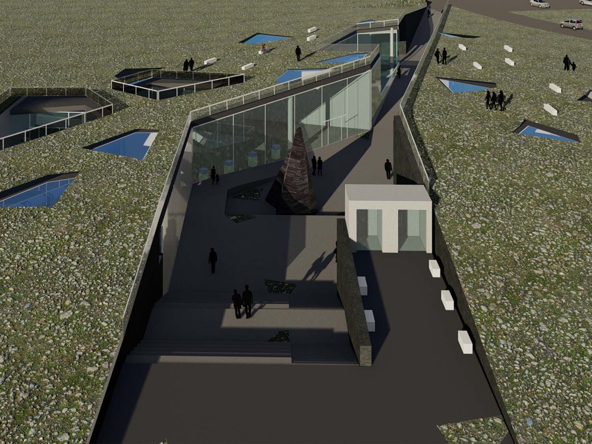
In the light of this information, the design was started. Since geology means earth science, it was decided to design the geology museum, learning and observation center below the ground. While the geology museum, learning and observation center were being designed, the main axis was first designed for circulation. The building, which was buried underground with this main axis, was divided into two. Conference and administrative units were placed on one side of the building, which was divided into two, and exhibition and laboratory units were placed on the other side. Thus, the people on the axis had to experience the square during the transitions between the masses. It was aimed to provide different experiences to people by dissolving the ramp on one end of this main axis and the staircase together with the amphitheater on the other. The building was closed together with the topography and a small hill was formed on the land. This hill has been inclined enough to be visited and seating areas have been placed. There were some lighting problems as the structure was buried under the ground. In order to solve these light problems, courtyards and skylights were designed in the building. The courtyards were transformed into workshop areas to support the exhibition areas. Skylights were also used in necessary spaces and to characterize the entrance.
To talk about the flow of the exhibition, the exhibition was divided into three main headings. Past, present and future. The past exhibition showcases how the world was formed, fossils and rocks. Now, laboratory units are exhibited in its exhibition, showing visitors how researchers are working on geology today. In the Future exhibition, VR technologies that describe the possible future states of the world are exhibited.