

Submergence Displacement Rehabilitation: Rethinking Resettlement as Cultural Continuity
A cluster-based resettlement framework that preserves village identity, kinship patterns, and agrarian livelihoods for communities displaced by India's Ken


When a dam submerges a village, the water doesn't just swallow houses. It erases courtyards where neighbors settled disputes, temples where generations marked seasons, and agricultural edges where livelihood and landscape merged into a single rhythm. India's Ken-Betwa River Link project threatens exactly this kind of erasure: 6,400 hectares of ecologically fragile forest within the Panna Tiger Reserve, 38 villages, and roughly 20,000 people whose social, economic, and spiritual systems are woven directly into the land beneath their feet.
Megha Yadav confronts these stakes head-on with Submergence Displacement Rehabilitation, a thesis project that rejects the top-down, grid-based resettlement models Indian government schemes have relied on for decades. Instead, Yadav proposes a cluster-based planning framework rooted in the spatial DNA of affected villages: their kinship hierarchies, shared courtyards, linear streets, water systems, and agricultural adjacencies. The result is not a housing scheme but a settlement strategy designed to carry forward the intangible structures that make a village a community.
Decoding the Village Before Rebuilding It
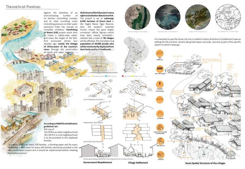
The opening presentation board reveals Yadav's analytical starting point: axonometric diagrams, sketches, and plans that dissect existing settlement typologies and the spatial relationships that government rehabilitation guidelines routinely ignore. The key insight here is that a village is not a collection of houses arranged on plots. It is a living landscape shaped by courtyards, community gathering zones, temples and shrines, water systems, agricultural edges, and linear streets of interaction. Yadav catalogs these elements systematically, building the case that any credible resettlement must recreate these intangible but essential components rather than simply distributing standardized plot sizes.
The critique of existing R&R models is specific and damning: lack of privacy in housing layouts, open spaces with no cultural or economic function, absence of the informal character that defines rural life, and a complete disregard for kinship-based spatial organization. By laying these failures alongside the spatial realities of the threatened villages, Yadav establishes a clear design brief grounded in four priorities: affordability, livability, longevity, and cultural continuity.
A Master Plan Organized Around Water and Agriculture
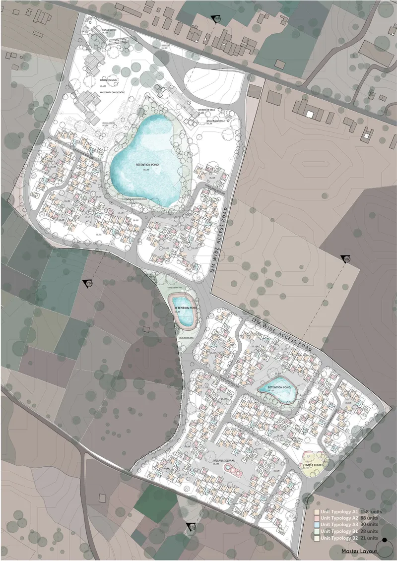
The master plan drawing makes Yadav's settlement logic legible at a glance. Three residential clusters organize themselves around central water bodies, with surrounding agricultural fields forming the settlement's productive edge. This is not decorative landscape planning. It is a deliberate replication of the agrarian adjacency that defines the displaced communities' livelihoods. Farmers don't commute to distant fields; the fields wrap around the clusters, preserving the daily rhythm of moving between home and cultivation that resettlement schemes typically sever.
The central water bodies serve a dual function: they anchor community life and recall the tanks, ponds, and river edges that structured social interaction in the original villages. The plan reads as an organism rather than a grid, with clusters connected by pedestrian-friendly streets and shared open spaces that emerge naturally from the arrangement of built forms rather than being imposed by a planner's geometry.
Cluster Type A: Courtyard Logic and Incremental Growth
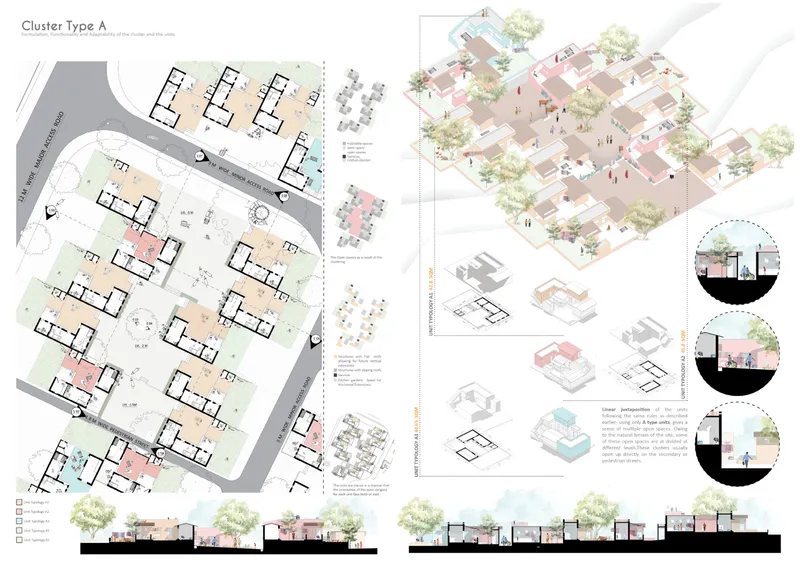
The detailed breakdown of housing cluster Type A shows how the macro logic of the master plan translates into built form. Site plans, isometric views, sectional diagrams, and elevations reveal a micro-neighborhood composed of multiple unit types (A1, A2, B1, B2) arranged to create shared courtyards and breathing open pockets. Houses follow courtyard-based patterns responsive to slope and land conditions, with activity spaces like shops, workshops, seating areas, and spill-out zones developing naturally at intersections between clusters.
Critically, the design embeds incremental expansion zones. Families grow, economies shift, and needs evolve. Rather than locking residents into a fixed footprint, the cluster allows future additions driven by family growth. This flexibility is one of the sharpest departures from conventional R&R models, which deliver a finished product and walk away. Yadav's approach treats the settlement as an ongoing process, not a one-time delivery.
Cluster Type B: Adapting Form to Terrain and Community
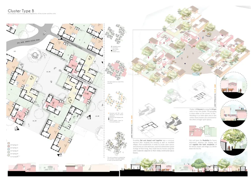
Cluster Type B offers a variation on the same principles, demonstrating that the framework is flexible rather than formulaic. The site plan and sectional diagrams reveal adjustments in unit orientation, open space configuration, and street alignment that respond to different terrain conditions. Where Type A favors courtyard-based arrangements, Type B introduces more linear patterns, allowing the cluster logic to adapt without losing its core commitment to shared space, pedestrian priority, and kinship-based proximity.
The elevations across both cluster types reinforce a consistent material and scalar language. These are not aspirational renderings of high-budget construction; they read as buildable, affordable, and familiar. The housing vocabulary draws from the spatial character of the displaced villages rather than importing an aesthetic from outside, a decision that serves both cultural continuity and practical construction logic.
Life Between Buildings: The Cluster as Social Infrastructure
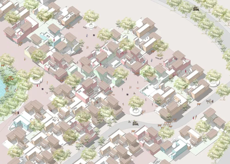
The axonometric rendering of a residential cluster captures what numbers and diagrams cannot: the feel of inhabitation. Dispersed housing units sit among mature trees, with pedestrians moving through courtyards, pausing at thresholds, and occupying the kinds of informal, in-between spaces that define rural settlement character. The rendering makes visible the project's central argument that open space in a village is never empty. It is where children play, where grain dries, where neighbors meet, where the boundary between private and public life dissolves into a gradient rather than a line.
This image is the project's strongest communicative tool because it shows what successful resettlement actually looks like: not rows of identical houses but a textured, breathing settlement where community life can take root again. The preservation of trees, the varied spacing between units, and the organic pedestrian circulation all point to a designer who understands that belonging is spatial before it is psychological.
Why This Project Matters
India's Interlinking of Rivers program will continue to displace communities for decades. The Ken-Betwa link is only the first of thirty planned connections, each carrying its own submergence footprint and its own population of uprooted families. The question is not whether displacement will happen but whether the architectural response will rise above the sterile plot-and-grid model that has failed communities repeatedly. Megha Yadav's thesis offers a credible, research-grounded alternative: a cluster-based framework that treats settlement design as an act of cultural preservation rather than logistical processing.
What makes this work valuable is its refusal to separate the house from the village, the village from the landscape, and the landscape from the livelihood. By beginning with the spatial DNA of the communities themselves, Yadav produces a resettlement model that is not imposed on people but grown from their existing patterns of life. In a field where rehabilitation architecture is too often an afterthought, this project insists that it should be the central design problem of our time.
View the Full Project
About the Designers
Designer: Megha Yadav’s
Enter a Design Competition on uni.xyz
uni.xyz runs architecture and design competitions year-round that reward proposals with spatial conviction and real site intelligence.
Project credits: Submergence Displacement Rehabilitation by Megha Yadav’s.


Popular Articles
Popular articles from the community


Singing Woman: Contemporary Architecture Inspired by Estonia’s Voice and the Sea
Singing Woman turns Estonia’s song culture into flowing opera house architecture, blending public life, landscape, sea, and national memory.
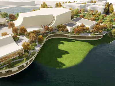
The Amber Palace Opera: A Geological Fiction Surfaces on Tallinn's Baltic Waterfront
Pierre Brillard reimagines a Baltic legend as a public landscape, opera house, and waterfront promenade rooted in Tallinn's coastal identity.
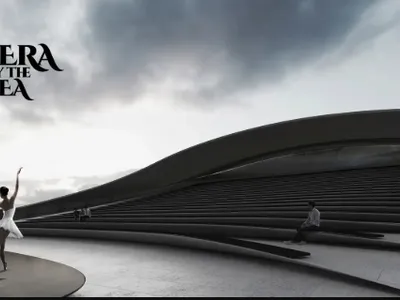
Opera by the Sea Estonia: Three Shells Dissolving Architecture into Tallinn's Coastline
A winning opera house proposal replaces monumental form with interconnected shells that blur the boundary between building, park and Baltic Sea.
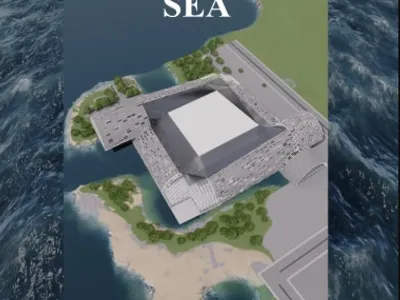
Opera on the Sea: Driftwood Logic Shapes a Timber Opera House on Estonia's Coast
Trevor Orgill's opera house translates the entangled drift of floating timber into a civic building where wood, water, and music converge.

Similar Reads
You might also enjoy these articles
The Amber Palace Opera: A Geological Fiction Surfaces on Tallinn's Baltic Waterfront
Pierre Brillard reimagines a Baltic legend as a public landscape, opera house, and waterfront promenade rooted in Tallinn's coastal identity.
Dynamic Modules Shelter: A Telescopic Ring for Mountain Pilgrimage
A circular modular framework of steel, bamboo, and fabric grows vertically with demand, wrapping communal ground in adaptable shelter.
Singing Woman: Contemporary Architecture Inspired by Estonia’s Voice and the Sea
Singing Woman turns Estonia’s song culture into flowing opera house architecture, blending public life, landscape, sea, and national memory.
HYPERBLOCK: Flexible Urban Design for Barcelona’s Future City
HYPERBLOCK reimagines Barcelona as flexible urban design, layering density, daylight, public space and adaptable housing above Cerdà’s grid.


Comments (0)
Please login or sign up to add comments
No comments yet. Be the first to comment!