
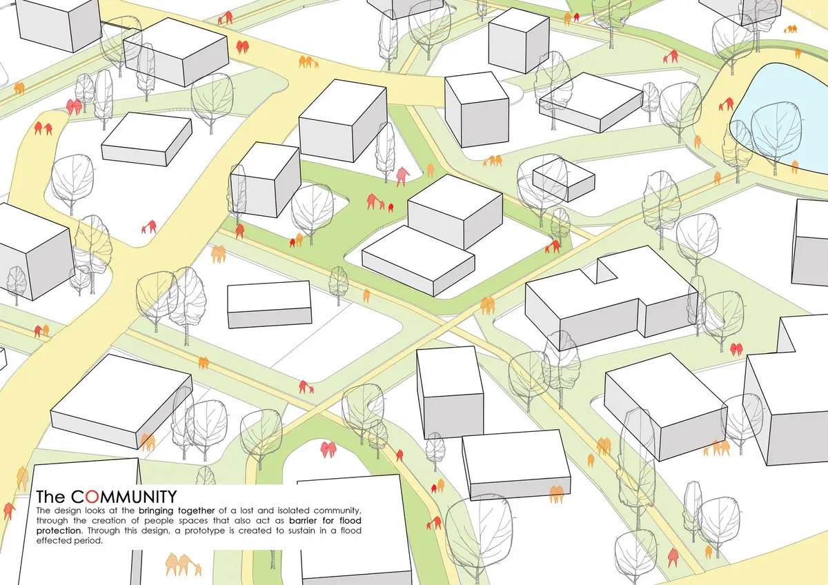
The Flood Resilient Community: Turning Floodwater into Food, Shelter, and Mobility
A 100-home settlement for Kerala where aquaponics pits, inverted roofs, and canal networks transform flood vulnerability into self-sufficiency.


What if the very water that destroys a community could also feed it? That premise sits at the center of The Flood Resilient Community, a 100-home settlement designed around the idea that flood infrastructure and food production can be the same system. Water collection pits double as aquaponics farms. Inverted roofs harvest rain. Canal networks that manage surge during monsoons become boat transport corridors when roads go under. Every element in the plan works at least twice.
Designed by Projects LBD and shortlisted for the HEAL+ competition, the project responds to Kerala's recurring flood crises with a settlement model organized around resilience, community development, and dwelling upgradation. Rather than treating disaster preparedness as a set of add-ons, the design embeds it into the master plan itself, from road geometry to roof pitch to the placement of green buffer zones.
Three Unit Typologies Built to Float Above the Flood Line
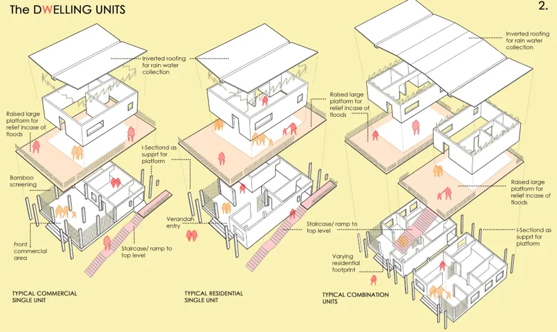
The axonometric drawing reveals three single-unit typologies, each elevated on raised platforms that serve dual roles: structural flood protection during inundation and open-air relief camp space when the waters rise. The inverted roof profiles are not stylistic choices. They function as rainwater harvesting surfaces, channeling collected water into storage systems and reducing the load on ground-level drainage. Secondary roofs and elevated platforms act as refuge points, providing safe zones for residents and secure storage for essential goods when floodwaters exceed the primary platform height.
The typologies are designed around the principle of dwelling upgradation: improving individual housing units beyond mere survival to ensure comfort, safety, and long-term sustainability. Each unit is conceived as a modular, adaptable structure rather than a fixed object, capable of responding to different flood severities and household needs.
Radial Roads, Canal Networks, and the Logic of Evacuation
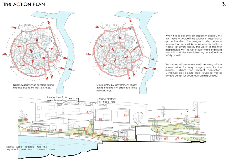
The site plan and section drawing make visible the evacuation infrastructure that is often invisible in conventional housing layouts. Radial road networks allow rapid exit during emergencies while also providing swift access for government relief forces. Waterways connect the five sectors of the settlement, each organized around a central water collection pit. During non-flood periods, these pits operate as aquaponics farms, producing food year-round. During severe flooding, the integrated canal system enables safe boat transport, turning the settlement's water challenge into a mobility asset.
Green buffer zones line the edges between sectors, functioning simultaneously as flood drainage channels and recreational open space. The section drawing shows how the water harvesting infrastructure along the canal connects back to the individual dwelling units, creating a continuous loop between collection, storage, and productive reuse. The plan avoids dead-end streets and cul-de-sacs, ensuring that every pathway offers multiple exit options.
A Modular Dwelling Prototype That Harvests Its Own Water
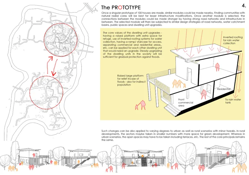
The final drawing sheet brings together site plan, axonometric, and elevation views to demonstrate how the modular dwelling prototype works at both the individual and settlement scale. The rainwater collection roof is the defining feature: its geometry is calibrated to capture maximum rainfall and direct it into storage, reducing dependence on external water supply during and after flood events. At the settlement level, the strategic placement of commercial areas ensures easy movement and supports post-disaster economic regeneration.
Organic farming plots occupy the green spaces between dwelling clusters, strengthening food resilience and giving residents a shared productive landscape to maintain. The design fosters what the designers call collective identity: a model where shared responsibility for green infrastructure, aquaponics systems, and communal spaces binds the settlement together socially, not just spatially. Parks double as drainage systems. Commercial zones are positioned for accessibility during both normal life and recovery periods.
Why This Project Matters
Flood-resilient design often defaults to a single strategy: raise the building. The Flood Resilient Community goes further by asking what the raised building, the diverted water, and the reorganized road can do when they are not performing their emergency function. The answer is food production, recreation, community building, and economic activity. That multiplicity is the project's real contribution. It treats resilience not as an engineering constraint but as a design generator.
For Kerala, where catastrophic flooding in 2018 and 2019 displaced millions, proposals like this carry weight beyond the competition brief. The 100-home scale is large enough to test systemic ideas like sector-based aquaponics and canal-based mobility, yet small enough to remain legible as a community. Projects LBD's shortlisted entry for HEAL+ demonstrates that sustainable architecture and disaster management are not parallel tracks but the same discipline, applied with enough imagination to see a flooded canal as a transportation network and a drainage pit as a fish farm.
View the Full Project
About the Designers
Designer: Projects LBD
Enter a Design Competition on uni.xyz
uni.xyz runs architecture and design competitions year-round that reward proposals with spatial conviction and real site intelligence.
Project credits: The Flood Resilient Community by Projects LBD HEAL+ (uni.xyz).


Popular Articles
Popular articles from the community


Cube Design Draws an Ecological Corridor Between Two Shenzhen Hills with the Nankai Building
Beside Shenzhen's container docks, the Nankai Building pairs stacked balconies with a climbing green screen to connect two hillsides across its height.

David Macias Steps a Doorless Stone and Plaster House Down a Tropical Colombian Hillside
In the humid hills of Colombia, Threshold House replaces the front door with an open void and terraces its 850 m² down the slope instead of fighting it.

longwave studio Reorganizes a 112 m² Tainan Apartment Around the Daily Routines of a Family and Two Cats
In Tainan, Taiwan, birch plywood, rust-red furniture and a freestanding plaster wall link arrival, storage, work and family life in one apartment.

Jaramillo Van Sluys Arquitectura and Urbanismo Turn a Demolished Registry Lot in Quito into an Orchard Plaza
In Quito's Centro Histórico, a 2,800 m² plaza exposes the San Agustín convent wall and redraws its lost Augustinian orchard in volcanic stone.

Similar Reads
You might also enjoy these articles

Gil Mello Arquitetura Tilts a Single Roof Toward the Waterfalls on a Plateau Above Aiuruoca, Brazil
In Aiuruoca, Minas Gerais, a 200 m² house of local labor and reclaimed poles pairs a low valley veranda with a tall mountain one.

U.GA Architects Wraps an Oval Rooftop Pool in Curved Board-Formed Concrete on Busan's Jeollidan-gil
In Busan's Jeonpo-dong, a 454 m² mixed-use block stacks a neighborhood facility, guest rooms and an oval rooftop pool inside spiraling concrete walls.

Felipe Hess Arquitetos Turns a Blind Stone Wall to the Street and Opens a Brazilian House onto a Courtyard and Canal
A canal-front house in Brazil hides behind painted stone and planting, then opens to an olive-tree courtyard, a reed-ceilinged porch and a curving pool.
David Macias Steps a Doorless Stone and Plaster House Down a Tropical Colombian Hillside
In the humid hills of Colombia, Threshold House replaces the front door with an open void and terraces its 850 m² down the slope instead of fighting it.


Comments (0)
Please login or sign up to add comments
No comments yet. Be the first to comment!