

Heal+: Regenerative Housing That Turns Kerala's Floodwaters into Community Resilience
A modular master plan for Aluva combines terraced rice paddies, elevated housing, and civic shelters to rebuild after Kerala's devastating monsoons.


What if the same water that destroys a community could be harnessed to feed it, protect it, and bind it together? That is the central provocation of Heal+, a regenerative housing proposal for Kerala's flood-ravaged Aluva region. Rather than treating monsoon floods as a problem to be engineered away, the project treats them as a design parameter, organizing terraced landscapes, modular dwellings, and civic infrastructure around the seasonal rhythms of water. The result is a framework where rice paddies double as flood barriers, bathing ghats absorb storm surges, and elevated community centers serve as emergency shelters.
Designed by Clara P for the Heal+ competition, the project takes the 2018 Kerala floods as its point of departure. Aluva, situated between Kochi and the city airport along India's southwestern coast, bore severe damage during those floods, and the region remains acutely vulnerable to heavy monsoon cycles. Clara P's proposal responds with both urgency and patience: a short-term action plan for recovery within a year, layered onto a 10 to 15 year master plan for scalable, self-sufficient community growth aligned with the UN Sustainable Development Goals.
Rice Paddies as Flood Infrastructure
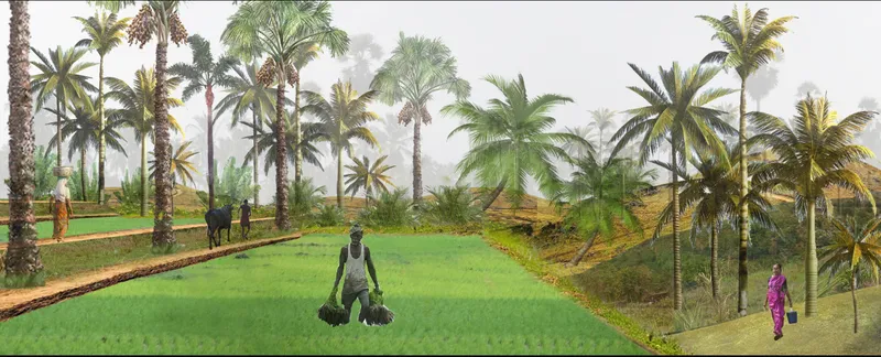
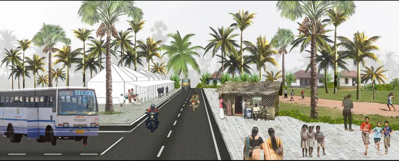
The opening perspective sets the tone: terraced rice paddies cascade through a palm-lined landscape, with a farmer carrying baskets through morning mist. It is a deliberately pastoral image, but the agricultural strategy it depicts is deeply functional. Multi-level crop fields and dams act as natural flood barriers, slowing and absorbing water before it reaches settlements. Rice planting provides food security while the terraced topography manages water retention across the site. Mangrove plantations along riverbanks reinforce this approach, preventing erosion and reducing flood damage at the edges where land meets water.
The second rendering shifts scale from landscape to street. An elevated walkway threads through palm groves alongside a principal roadway accommodating bus transit. Roads here are designed for flexibility, balancing pedestrian movement with public transport and flood-adapted infrastructure. The elevation of the pedestrian path is not merely aesthetic; it keeps foot traffic viable during high-water events, maintaining connectivity when ground-level routes become impassable.
Layered Landscapes That Absorb and Redirect
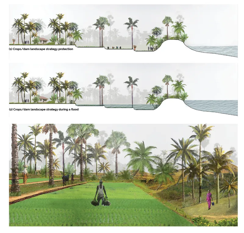
A composite rendering reveals the full flood mitigation landscape strategy at work. Cultivated terraces step down through the site, populated with pedestrians moving through the planted zones. Retention basins, culverts, and integrated water management infrastructure sit beneath this productive surface. The proposal treats these interventions not as emergency additions but as permanent landscape features: compost toilets, waste recycling systems, irrigation tanks, and solar farms are woven into the terrain, enabling resource self-sufficiency even outside flood events.
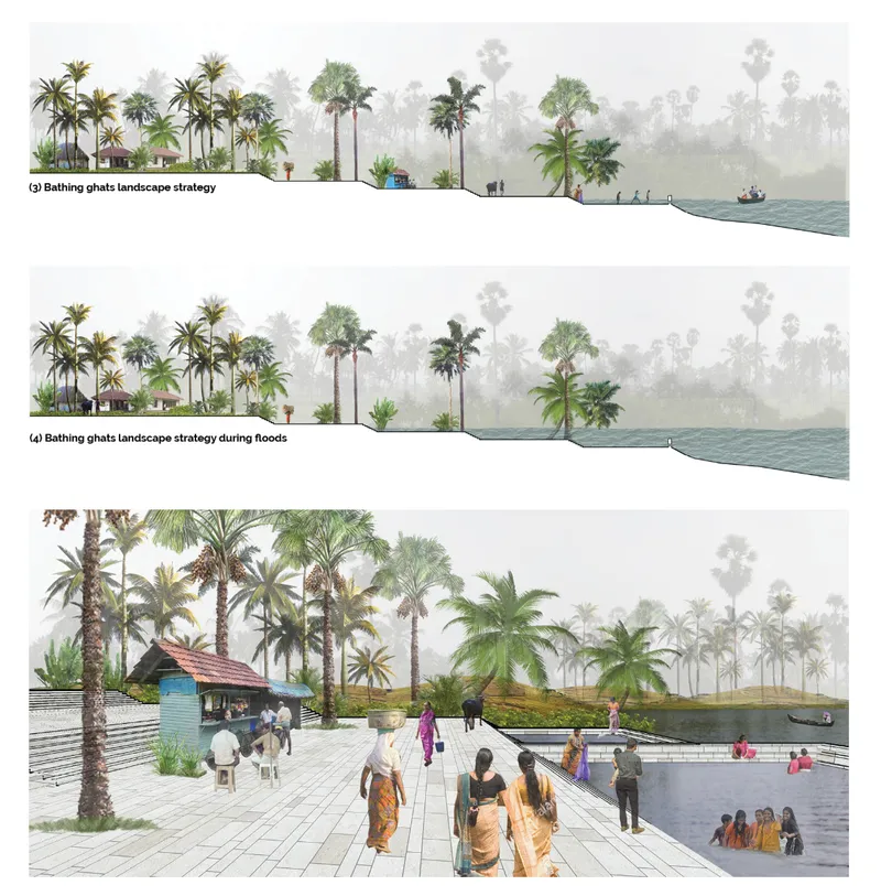
The waterfront rendering is the most spatially ambitious image in the set. Stepped bathing ghats descend into the water, flanked by dense palm forest, depicted during flood conditions that test the system's capacity. These ghats serve triple duty: daily public gathering space, cultural bathing ritual infrastructure, and storm surge absorption zone. Public squares, shaded walkways, and gathering areas throughout the master plan follow the same logic, enhancing community interaction while functioning as multi-use flood mitigation zones. The project's insistence that every public space earn its keep during both calm and crisis is one of its strongest moves.
Section Strategies: Elevated Living and Road Typologies
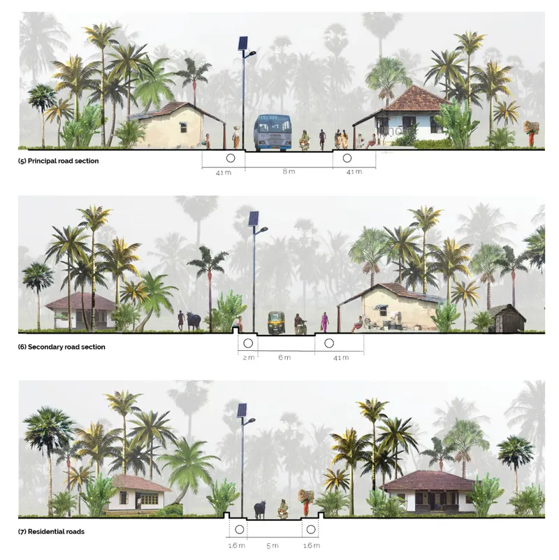
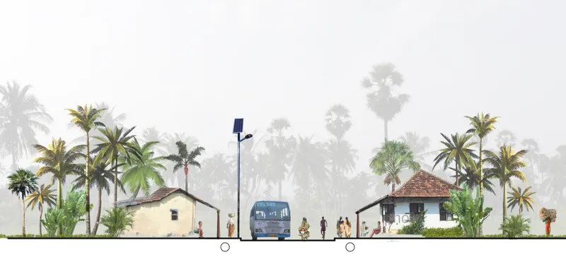
The section drawings lay bare the technical scaffolding behind the atmospheric renderings. Multiple road typologies are shown at various scales, each calibrated to its context: palm trees provide shade structure, houses are elevated above anticipated flood levels, and pedestrian circulation is separated from vehicular traffic. These are not generic street sections; they respond to specific conditions along the Aluva site, from narrow residential lanes to the principal road that accommodates bus transit.
The final section elevation brings the residential strategy into focus. Housing units are designed as elevated, modular structures that can be replicated and scaled as the community grows over the 10 to 15 year master plan horizon. Shared civic centers anchor clusters of dwellings, functioning as daily community hubs for education and cultural events while converting to emergency shelters during floods. Materials prioritize locally available resources: wood, earth, and stone, supplemented by recycled materials from reconstruction efforts. Decentralized solar panels and community generators ensure energy resilience when centralized grids fail.
Community Resilience Beyond the Building
What distinguishes Heal+ from a standard disaster recovery proposal is its refusal to separate physical infrastructure from social infrastructure. Local refuges are not afterthoughts; they are the civic hearts of each housing cluster, designed to accommodate daily life and emergency life with equal seriousness. Education, cultural gatherings, and emergency relief share the same footprint. The proposal understands that communities shattered by flood do not just need new walls; they need reasons to stay, gather, and invest in collective futures.
Why This Project Matters
Heal+ matters because it refuses the false choice between immediate relief and long-term planning. The short-term action plan, covering material reuse, infrastructure restoration, and energy decentralization within a year, feeds directly into the 10 to 15 year master plan for modular growth. There is no phase where the community is merely surviving and waiting for the real plan to begin. Every reconstruction effort contributes to the permanent landscape. Every temporary measure is designed to become a permanent asset.
Clara P's proposal redefines what regenerative housing can mean in a flood-prone context. It is not about building higher walls or retreating from the water. It is about reorganizing an entire community's relationship with its landscape so that the next flood is not a catastrophe but a seasonal event the architecture already anticipated. For regions across the global south facing intensifying monsoons and rising waters, the Aluva model offers a blueprint worth studying closely.
View the Full Project
About the Designers
Designer: Clara P
Enter a Design Competition on uni.xyz
uni.xyz runs architecture and design competitions year-round that reward proposals with spatial conviction and real site intelligence.
Project credits: Building resilient and sustainable communities by Clara P Heal+ (uni.xyz).


Popular Articles
Popular articles from the community

Opera on the Sea: Driftwood Logic Shapes a Timber Opera House on Estonia's Coast
Trevor Orgill's opera house translates the entangled drift of floating timber into a civic building where wood, water, and music converge.

Aquadapt: An Underwater Habitat That Rewrites Its Rooms by the Hour
Curved modules ring the seabed while one shell shifts from breakfast room to cinema, farm and football pitch as residents' needs change.


graciastudio Turns a Viewless Tijuana Lot Inward Around a Courtyard of Concrete, Timber and Trees
In Tijuana, Jorge Gracia's GA2 House stacks a timber-clad private floor over exposed concrete and replaces a missing view with a planted interior patio.
The Amber Palace Opera: A Geological Fiction Surfaces on Tallinn's Baltic Waterfront
Pierre Brillard reimagines a Baltic legend as a public landscape, opera house, and waterfront promenade rooted in Tallinn's coastal identity.

Similar Reads
You might also enjoy these articles

Cube Design Draws an Ecological Corridor Between Two Shenzhen Hills with the Nankai Building
Beside Shenzhen's container docks, the Nankai Building pairs stacked balconies with a climbing green screen to connect two hillsides across its height.

Praksis A and Studio Sted Bend a Red Timber Cabin Across the Granite of Norway's Southern Coast
On the southern Norwegian coast, a 105 m² cabin follows the rock on slender posts, pairing red cladding outside with pine, brick and plywood within.

David Ortega Stacks a Two-Story Mexico City Penthouse Around a Steel Stair and a Pergola-Shaded Roof Terrace
In Colonia Roma, a 300 m² penthouse uses oak joinery, a planted steel stair and a slatted roof pergola to make a new-build apartment feel like a house.

PARALELA and LB2 Thread a Public Walkway Through the Base of a Las Condes Residential Tower
In Las Condes, Santiago, the Hamlet Building gives its fenceless ground floor to a 70-metre wooded passage linking two streets and the metro.

Comments (0)
Please login or sign up to add comments
No comments yet. Be the first to comment!