

New Delhi: Boundless Sprawl Reimagines Connaught Place as a Pedestrian-First District
A multi-level infrastructure strategy dissolves the rigid boundaries of New Delhi's colonial-era commercial center to reclaim space for people.


Connaught Place is one of the most recognizable urban forms in South Asia: a concentric ring of colonnaded buildings that has served as New Delhi's commercial heart since the 1930s. It is also, by most accounts, suffocating. Traffic congestion overwhelms its radial roads, pedestrian access is an afterthought, and the green space that once softened its geometry has been paved over or walled off. New Delhi: Boundless Sprawl takes this diagnosis seriously. Rather than treating Connaught Place as a heritage artifact to preserve under glass, the project proposes a comprehensive restructuring of its infrastructure, ground plane, and programmatic mix to turn it into something it has never quite been: a district designed around walking.
Designed by Woobin Choi and 주희 이, the project received an Honorable Mention in the Neo Delhi competition. The brief challenged participants to reimagine New Delhi's urban core, and Choi and 이 responded with a strategy that operates at two scales simultaneously: a macro-level extension of Connaught Place's radial geometry outward into surrounding neighborhoods, and a micro-level reworking of its streets and blocks to weave in green pockets, cultural programs, and separated vehicular traffic.
Radial Logic Extended Beyond the Ring
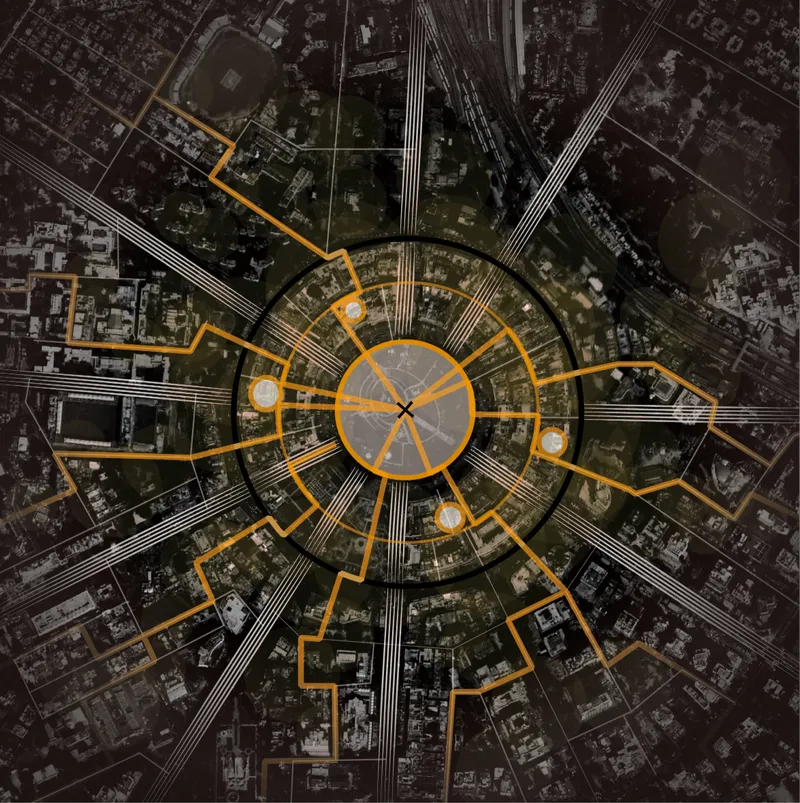
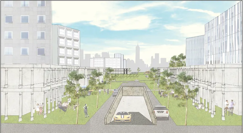
The aerial site plan makes the core move immediately legible. An orange overlay traces development fingers radiating outward from Connaught Place's circular hub, reaching into the surrounding urban fabric. The designers treat the existing ring not as a boundary but as a generator, using its geometry to organize new connections to adjacent districts. Where the current condition isolates Connaught Place behind heavy traffic arteries, the proposal stitches it back into the city by extending pedestrian-priority corridors along those radial lines.
A perspective rendering shows what one of these corridors could feel like at eye level: a tree-lined street where an elevated roadway carries vehicles above, freeing the ground plane for people moving on foot under a filtered canopy. The haze in the rendering is honest about New Delhi's atmospheric conditions, but the spatial proposition is clear. Cars still exist in this city; they simply no longer own every surface.
Street Sections That Tell the Truth
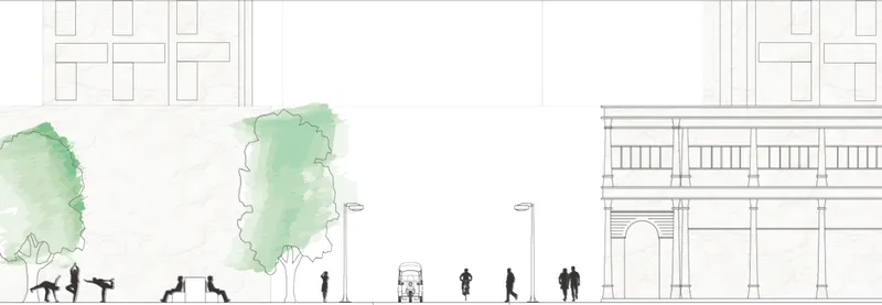
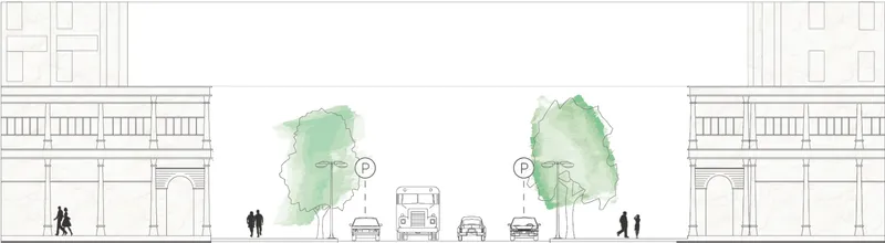
Two elevation drawings document the transformation at the scale of the street. The first shows a streetscape flanked by mid-rise buildings, with watercolor trees softening the facades and silhouetted figures establishing a comfortable pedestrian scale. The second introduces the harder reality of parking, vehicles, and foliage coexisting in a single section. These are not fantasies of car-free utopia; they are negotiations. The designers acknowledge that New Delhi's traffic cannot be wished away and instead propose to manage it through layered infrastructure, separating modes vertically so that surface-level space can be reclaimed incrementally.
Green Pockets Carved Into the Block Structure
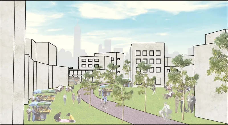
One of the proposal's most compelling strategies is the introduction of small, interconnected green spaces threaded through the built mass. A perspective rendering depicts a sloped park with a winding path, framed by low-rise buildings that step down to meet the landscape. The intent is to break up the monolithic block structure of Connaught Place's surroundings and replace it with a more porous urban grain where people encounter planted ground frequently as they move through the district.
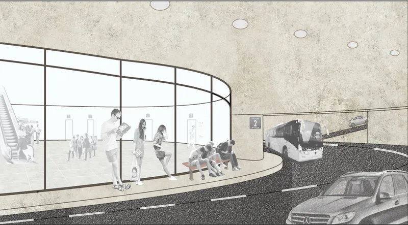
A section drawing reveals another layer of this multi-level thinking: a curved glazed waiting area, populated with seated figures, sits above a vehicular roadway level. Transit infrastructure becomes a public amenity rather than a utilitarian afterthought. The glazed enclosure offers weather protection (critical during Delhi's monsoon and summer extremes) while maintaining visual continuity between the transit level and the street.
Public Space as Civic Infrastructure
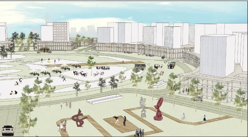
A rendering of a public plaza reveals the programmatic ambition behind the spatial restructuring. Sculpture installations, planted areas, and curving building edges define an open-air room that could host cultural events, religious gatherings, or political assembly. The designers explicitly list commercial, cultural, religious, political, and inclusive programs as drivers of the new district, and this plaza reads as the spatial expression of that aspiration. The curving architecture echoes Connaught Place's original circular geometry without mimicking it.
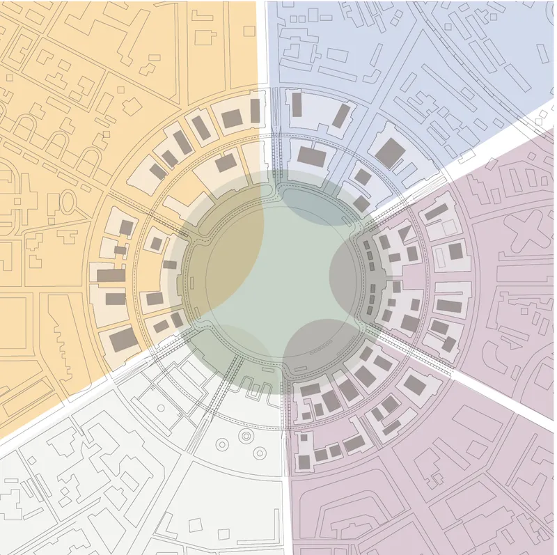
A detailed site plan confirms the organizational logic: a circular central park anchors the composition, surrounded by radiating building blocks that alternate between built mass and open ground. The pattern creates a rhythm of compression and release that would reward walking and discourage the kind of car-dependent shortcuts that currently dominate movement through the area.
A Skyline Shaped by Program, Not Speculation
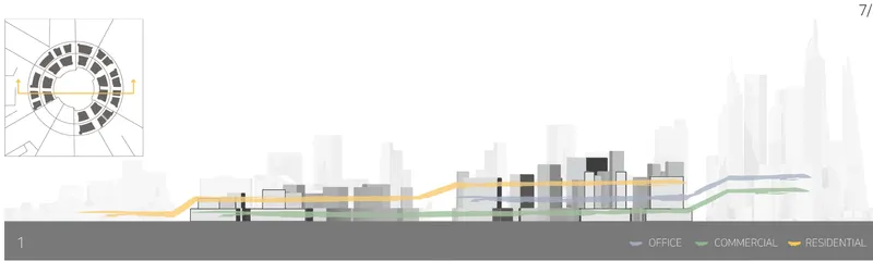
The final elevation drawing stretches across the full width of the proposed development, documenting the varying building heights across what the designers envision as a mixed-use urban district. The skyline is deliberately uneven, suggesting that height responds to program and context rather than a uniform FAR maximization. Lower volumes frame public spaces and green pockets; taller blocks mark intersections or accommodate denser commercial uses. It is an elevation that reads as a city, not a single development parcel.
Why This Project Matters
New Delhi's relationship with its colonial-era urban plan is complicated. Connaught Place was designed for a city of a few hundred thousand; it now serves a metropolitan area of over 30 million. Most interventions in the area have been additive and reactive: more parking, more flyovers, more barriers. Boundless Sprawl inverts that logic. By weakening boundaries, separating traffic vertically, and distributing green space through the urban grain, Choi and 이 propose a systemic rethinking rather than a piecemeal fix.
The project's strength lies in its willingness to work with the existing radial geometry rather than against it. Too many competition entries for sites like this either erase the historical plan or freeze it in amber. Here, the circle becomes a centrifugal force, throwing energy outward into the surrounding city and pulling people inward toward a reimagined public core. That is a spatial argument worth paying attention to.
View the Full Project
About the Designers
Designers: Woobin Choi, 주희 이
Enter a Design Competition on uni.xyz
uni.xyz runs architecture and design competitions year-round that reward proposals with spatial conviction and real site intelligence.
Project credits: New Delhi_ Boundless Sprawl by Woobin Choi, 주희 이 Neo Delhi, (uni.xyz).


Popular Articles
Popular articles from the community

Faces of the Soviet Avant-Garde: Turning Moscow's Street Names into an Open-Air Museum
A network of sculptural installations across a Moscow residential district transforms forgotten architect names into spatial encounters with cultural memor
Opera on the Sea: Driftwood Logic Shapes a Timber Opera House on Estonia's Coast
Trevor Orgill's opera house translates the entangled drift of floating timber into a civic building where wood, water, and music converge.

Cloaked Colonization: A Mobile Underwater Habitat That Moves Like a Fish
Micah Abaya's shortlisted EHC Pacific entry reimagines ocean settlement as a dispersed network of self-sustaining architectural organisms.

Tsunami Convergenics: Turning Catastrophic Ocean Forces into Underwater Housing Infrastructure
A speculative underwater settlement off the coast of Onagawa, Japan, treats tsunamis and typhoons as energy sources rather than threats.

Similar Reads
You might also enjoy these articles
The Amber Palace Opera: A Geological Fiction Surfaces on Tallinn's Baltic Waterfront
Pierre Brillard reimagines a Baltic legend as a public landscape, opera house, and waterfront promenade rooted in Tallinn's coastal identity.
Dynamic Modules Shelter: A Telescopic Ring for Mountain Pilgrimage
A circular modular framework of steel, bamboo, and fabric grows vertically with demand, wrapping communal ground in adaptable shelter.

Singing Woman: Contemporary Architecture Inspired by Estonia’s Voice and the Sea
Singing Woman turns Estonia’s song culture into flowing opera house architecture, blending public life, landscape, sea, and national memory.
HYPERBLOCK: Flexible Urban Design for Barcelona’s Future City
HYPERBLOCK reimagines Barcelona as flexible urban design, layering density, daylight, public space and adaptable housing above Cerdà’s grid.

Comments (0)
Please login or sign up to add comments
No comments yet. Be the first to comment!