

Urban Seed: Rooting Cities in Ecological Balance Through Agricultural Infrastructure
A conceptual framework that treats farms as urban roots, markets as branches, and open spaces as the canopy where communities gather and thrive.


What if a city grew the way a tree does? Urban Seed takes that question literally, proposing an architectural framework where farms act as roots, markets extend as branches, and open public spaces form a canopy sheltering the communities beneath. The project belongs to a larger speculative framework called Urban Meal Mine, and it positions agriculture not as a peripheral amenity but as the structural backbone of urban life. Food production, processing, and distribution are woven directly into the spatial logic of the city, collapsing the distance between field and fork into a single, legible system.
Designed by Apoorva Marathe, Krishna Kansara, Sachan Shobhan, and Sumedh Gangurde, Urban Seed reframes the typical masterplan exercise. Instead of zoning land for maximum density or commercial yield, the designers organize territory around ecological cycles: growth, harvest, consumption, renewal. The result is a proposal that reads as part agricultural strategy, part urban manifesto, arguing that resilient cities must be, at their core, productive landscapes.
A Seed Becomes a City: The Growth Metaphor Made Spatial
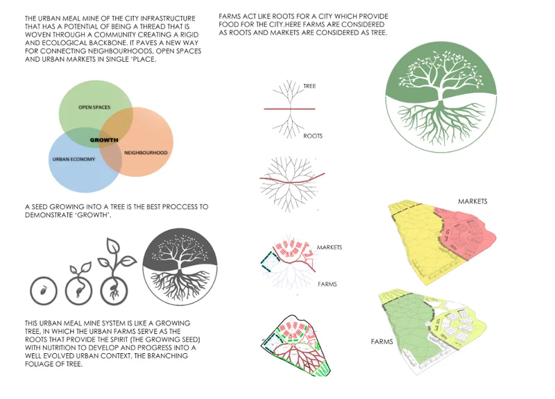
The opening diagram lays out the project's conceptual engine. A tree cross-section doubles as an urban section: roots below ground represent farming infrastructure, the trunk corresponds to processing and distribution networks, and the canopy maps onto public spaces and market zones. Growth phases are charted alongside, showing how the seed metaphor translates into a phased development strategy. It is a bold visual thesis, establishing that this is not simply a farm-adjacent housing scheme but a holistic ecosystem where each programmatic element feeds the next. The cyclical logic of food production, consumption, and organic renewal becomes the organizing principle for every design decision that follows.
Six Phases from Bare Ground to Vegetated Boundary
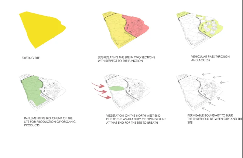
The six isometric diagrams trace a layered site development sequence, beginning with existing conditions and culminating in a fully vegetated boundary. Each phase introduces a distinct operational layer: zone segregation separates farming areas from markets and housing; vehicular and pedestrian access networks are carved to keep agricultural zones protected from through traffic; green buffer strips are positioned for cross-ventilation and to create a breathable microclimate. The final phase shows permeable edges that blur the threshold between urban infrastructure and farmland, refusing the hard boundary that conventional zoning would impose.
What makes the sequence compelling is its legibility. Rather than presenting a finished masterplan and asking the viewer to reverse-engineer the logic, the designers expose every decision in order. You can see when the greenhouse for exotic crops enters the plan, when poultry and livestock farms claim their plots, and how farmers' housing is sited relative to production zones. It is transparent design reasoning, and it builds trust in the final composition.
Farm Zones and Market Areas Anchored to Real Ground
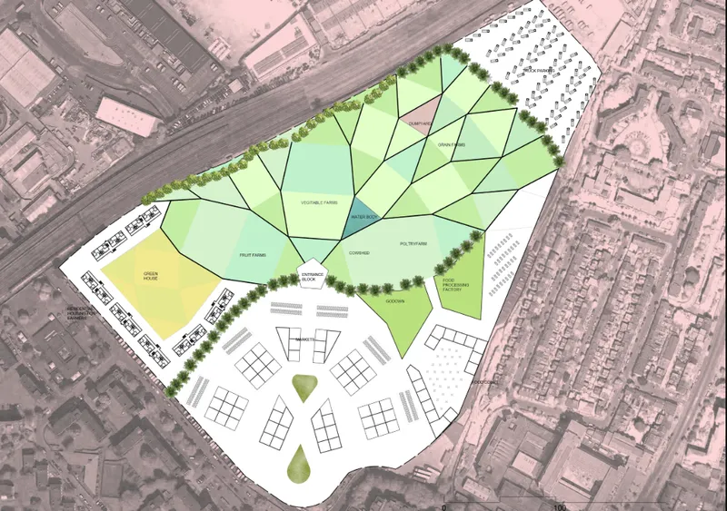
Overlaid on an aerial photograph, the site plan grounds the concept in physical territory. Farm zones, including vegetable plots, fruit orchards, and grain fields, occupy a large portion of the site, reinforcing the project's commitment to self-sufficiency. Market areas are positioned at the edges, functioning as the interface between the productive landscape and the surrounding urban fabric. Supporting infrastructure (godowns, storage silos, food processing units, and shared workshops) occupies a middle band, mediating between raw production and public-facing commerce. The plan makes clear that this is not decorative urban farming; it is operational infrastructure scaled to supply local markets and reduce food miles in a measurable way.
Program Elements: Barns, Greenhouses, Markets, and Housing
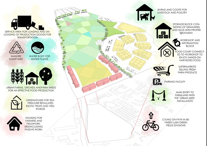
The axonometric drawing itemizes the full program through annotated icons: barns and livestock shelters, a greenhouse for climate-controlled cultivation, an open-air market hall, food courts and supermarkets linked to local farms, and clusters of farmers' housing. Cycling paths and pedestrian routes thread through the composition, reducing vehicle dependency and reinforcing the project's stance on low-carbon mobility. The drawing reads almost like an instruction manual for a new kind of settlement, one where economic activity, dwelling, and food production share not just proximity but mutual dependence.
Community integration is embedded at the programmatic level. Shared workshops sit adjacent to housing, creating spaces where knowledge transfer between farmers and residents can happen informally. Water bodies double as irrigation reservoirs and public amenities. The proposal does not treat social and environmental goals as separate line items; they are fused into the same spatial moves.
Why This Project Matters
Urban Seed matters because it refuses the false choice between density and ecology. Most urban agriculture proposals end up as rooftop gardens or community allotments, valuable but marginal. Marathe, Kansara, Shobhan, and Gangurde go further by treating farming as a foundational urban system, equal in status to transportation or housing. The result is a framework where food sovereignty, climate adaptation, and economic resilience are not add-ons but structural requirements of the plan.
The tree metaphor could easily have been decorative. Instead, the designers use it as a rigorous organizational device, mapping roots to farms, trunk to processing, and canopy to public life, then proving the logic through phased site diagrams and a detailed program breakdown. Whether or not Urban Seed ever breaks ground, its value lies in the argument it constructs: that cities can grow like living organisms, drawing sustenance from the land they occupy rather than consuming it.
View the Full Project
About the Designers
Designers: Apoorva Marathe, Krishna Kansara, Sachan Shobhan, Sumedh Gangurde
Enter a Design Competition on uni.xyz
uni.xyz runs architecture and design competitions year-round that reward proposals with spatial conviction and real site intelligence.
Project credits: Urban Seed by Apoorva Marathe, Krishna Kansara, Sachan Shobhan, Sumedh Gangurde.


Popular Articles
Popular articles from the community

Tsunami Convergenics: Turning Catastrophic Ocean Forces into Underwater Housing Infrastructure
A speculative underwater settlement off the coast of Onagawa, Japan, treats tsunamis and typhoons as energy sources rather than threats.
Extended Shell: Retrofitting Kolkata's Balconies as Living Urban Thresholds
A modular retrofit system recovers the social and environmental intelligence of Kolkata's historic verandas for contemporary Park Street residents.
Opera by the Sea Estonia: Three Shells Dissolving Architecture into Tallinn's Coastline
A winning opera house proposal replaces monumental form with interconnected shells that blur the boundary between building, park and Baltic Sea.

Singing Woman: Contemporary Architecture Inspired by Estonia’s Voice and the Sea
Singing Woman turns Estonia’s song culture into flowing opera house architecture, blending public life, landscape, sea, and national memory.

Similar Reads
You might also enjoy these articles
Bao Huynh Watercolor Atelier: A Serene Art Retreat in Hội An
Bao Huynh Watercolor Atelier in Hội An blends multifunctional art spaces, sustainable design, local materials, and family-friendly living in a serene environment.
Atelier Macri Concept Store Interior Design by CASE-REAL
Atelier Macri store features a "ko" counter, walnut wood details, cork displays, blending retail, gallery, and seamless customer experiences.
Manuel Vargas Izquierdo Stadium and High-Performance Sports Center: Architectural Excellence in Jalpa de Méndez
The Manuel Vargas Izquierdo Stadium blends sustainable design, inclusive sports facilities, and cultural-inspired architecture, revitalizing Jalpa de Méndez’s public spaces.
KAKR Buluh Awar Hall: Revitalizing Community and Ecology Through Bamboo Architecture
Community built bamboo hall revitalizes Buluh Awar village, empowering youth, restoring ecology, celebrating vernacular craftsmanship through sustainable architecture and culture.

Comments (0)
Please login or sign up to add comments
No comments yet. Be the first to comment!