Usage of the railway infrastructure areas for creating public spaces
Comprehensive work proves that the railway can be not an obstacle, but a part of the green frame of the city, a point of attraction for residents and tourists, a space that unites the urban fabric of two districts.
Modern cities are rapidly growing, so the pace of construction is constantly increasing. Many cities have already faced the problem of lack of territory to ensure their growth and vitality. The general trend is expanding urban boundaries. However, within each large city there is a large-scale territorial resource – railway infrastructure.
The territories liberated in this way are striking in their magnitude: for Moscow – 4.000 hectares; According to the British engineering company WSP, 250.000 new buildings can be erected in the urban area of London - a significant potential for a city with an acute shortage of territory. The solutions on these areas are diverse: from the construction of high-rise complexes, to the local pedestrian landscaped bridges.
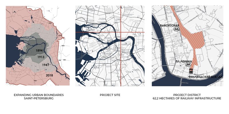
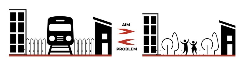
The design area (S = 4 ha.) - Sorting station St. Petersburg - Finland - has a good urban planning position: it is located in the heart of a developing area with large volumes of residential construction and has a rich historical past, but the district lacks public spaces and functions; it is in social discrimination. There are a number of problems typical for the railroad territories: gaps in the urban fabric, lack of cross-connections through the rails, outdated transport system, economic and social depression, lack of landscaping and poor environmental situation.
The aim of up-the-rails spaces designing is a harmonious and integrated solution to the problems caused by the railway infrastructure.
To create a full-fledged multifunctional public space, an integrated approach to the design of open and closed multi-level public spaces with a link to city-wide systems has been developed.
The approach is represented by the following design strategies:
1. Union - unite the city through the formation of additional development and expansion of the street network.
2. Transportation HUB – HUB will attract citizens and support social activity.
3. Context connection - a convenient transport space, both for pedestrians and for motorists, associated with existing transport and pedestrian routes.
4. Central Park - a large park zone to satisfy the request of future and current local residents for a recreation and to improve the ecological situation.
5. Public function - organization of a cultural and educational cluster with the office function.
Using this 5 design strategies, a powerful public space is formed.
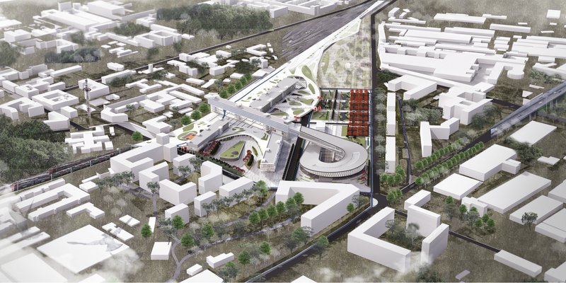
HUB is formed by a city train station on existing railway tracks, organization of a bus station and creation of intercepting parking lots. Community Center - a mall, a hotel with associated facilities and an office center located in a horizontal skyscraper. A cultural center with exhibition halls is integrated into the green zone. The park is divided into: the upper and the lower parks. The lower park - continuation of the linear park, is formed with preservation of railway tracks as an element of “place memory” and forms a pedestrian landscaped approach to the cultural center. The Upper Park is located on a platform above the bus station, railway tracks and utility sites, providing communication between the two parts of the city. Green areas are the connecting element of the whole complex and form a single park structure, dissolving the buildings.
The project forms a multifunctional platform aimed at providing future residents of the region with all necessary infrastructure. The proposed environment organizes a cultural cluster that transforms the space and makes it attractive.