

Building Smarter, Building Together: Cooperative Flood Resilience for Kerala's Communities
A community-driven housing strategy that transforms neighborhoods into resilient networks through shared infrastructure, smart streets, and adaptive landsc


What if the street you walk on every morning could warn you about a flood, then help you survive it? Building Smarter, Building Together (BSBT) treats the entire built environment as an active participant in flood management rather than a passive victim. The proposal organizes 100-household communities around shared infrastructure: raised plazas that become kayak launch points during inundation, farmlands that double as passive flood barriers, and streets that function as real-time communication networks when disaster strikes. It is a fundamentally cooperative model, where groups of five to ten families collectively designate evacuation centers, pool rebuilding costs, and modify structures together.
Designed by Design Office of Global Cities, BSBT was shortlisted in the HEAL+ competition, which sought regenerative housing solutions for Kerala. The project draws directly from the Kerala floods of 2018, where community solidarity proved decisive in rescue and recovery. Rather than proposing a single resilient building, BSBT scales the response to the neighborhood level, combining spatial design, digital flood management systems, and socio-economic investment strategies into one layered framework.
A Raised Plaza That Becomes a Waterway
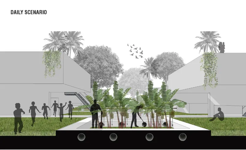
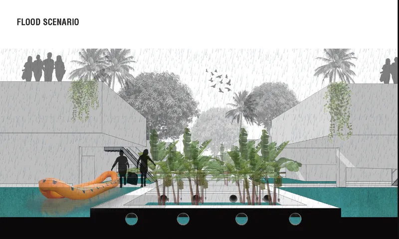
The paired section drawings tell the story most clearly. In everyday conditions, a raised plaza sits among banana plants and palm trees, with silhouetted figures moving through a generous public space. When the floodwaters arrive, the same section fills with blue, and kayakers navigate what was previously solid ground. The elevated ground level protects key structures while the lower landscape absorbs stormwater. It is a deliberately dual-use design: the sunken garden spaces that encourage daily community life also serve as stormwater catchment zones during flood events. Nothing is single-purpose.
The design philosophy here refuses to treat flood resilience as an occasional emergency measure layered onto normal life. Instead, the spatial organization assumes flooding will happen and builds that assumption into every decision about grade, planting, and circulation. The elevated areas do not feel like fortifications; they feel like a plaza you would want to spend time in.
Scattered Clusters Along Curving Roads
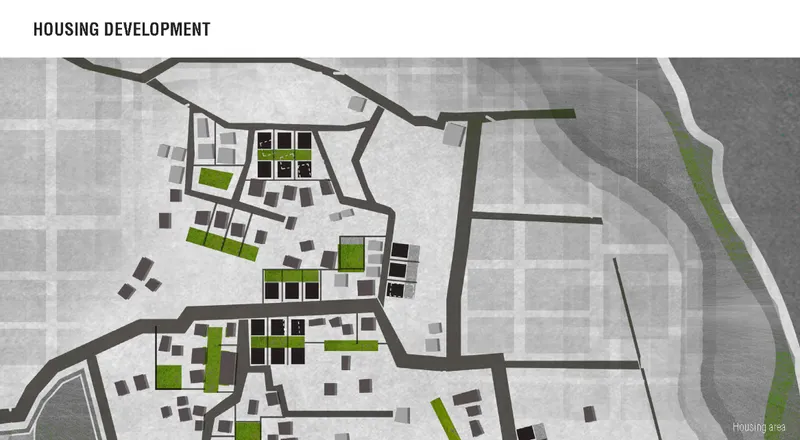

The site plan reveals a deliberate scatter of housing blocks organized around green courtyards and connected by curving road networks. This is not a conventional grid. The layout supports smart zoning with designated flood exit routes, early-warning systems, and connected rescue centers woven into the street pattern. Abandoned lots within existing settlements are repurposed into community-driven housing clusters, achieving re-densification without displacing residents. The axonometric drawing brings this to life: compact housing clusters capped with yellow canopy roofs sit among dense palm trees and landscaping, suggesting a settlement that grows with its ecology rather than against it.
Floodplain farming occupies the land between clusters, turning agricultural areas into natural flood barriers and water catchment zones. Ecological water sanctuaries prevent erosion and restore river health. The pedestrian-friendly street edges encourage active community life on ordinary days and become coordinated evacuation routes when alerts come through. The site plan reads as a neighborhood that has absorbed its flood risk into its bones.
Layered Flood Response from Household to Landscape

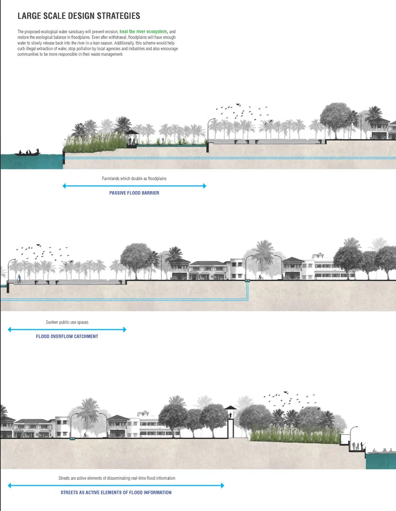
The diagrammatic drawings unpack the multi-layered defense system at work. One diagram maps the flood response strategies across housing typologies, linking sectional drawings of individual homes to community warning icons that indicate how information flows through the network. Real-time flood data is disseminated through streets and community infrastructure, with smart devices, digital mapping, and early-warning systems ensuring coordinated responses. The second set of section drawings isolates three distinct strategies: passive flood barriers through farmlands, overflow catchments embedded in public-use spaces, and street inundation management that uses vegetation and grading to slow and direct water.
What makes these diagrams compelling is their emphasis on the cooperative dimension. Larger community buildings like schools and hospitals are upgraded as elevated flood-proof spaces shared by the entire neighborhood. NGOs and local organizations are embedded in the framework to provide training in sustainable building practices and flood response. Government buy-back schemes and incentives for resilient housing upgrades complete the picture. The architecture alone does not solve the problem; the social and institutional infrastructure around it does.
Why This Project Matters
BSBT resists the temptation to design a single heroic structure that withstands floods. Instead, it proposes a network: five to ten families sharing costs, streets that double as warning systems, sunken gardens that catch stormwater, and farmland that absorbs overflow. The resilience is distributed across scales, from the individual elevated house to the neighborhood site plan to the regional floodplain management strategy. That distribution is what makes the proposal credible. A single building can fail; a network can absorb, adapt, and recover.
Perhaps the most valuable contribution of this project is its insistence that community participation is not a soft add-on to technical design but the structural foundation of resilience itself. Kerala's 2018 floods proved that solidarity saves lives. BSBT takes that lesson and gives it spatial form: shared walls, shared plazas, shared warning systems, shared costs. For flood-prone communities around the world, this kind of cooperative architecture may be the most practical path forward.
View the Full Project
About the Designers
Designer: Design Office of Global Cities
Enter a Design Competition on uni.xyz
uni.xyz runs architecture and design competitions year-round that reward proposals with spatial conviction and real site intelligence.
Project credits: Building Smarter, Building Together (BSBT) by Design Office of Global Cities HEAL+ (uni.xyz).


Popular Articles
Popular articles from the community


Cube Design Draws an Ecological Corridor Between Two Shenzhen Hills with the Nankai Building
Beside Shenzhen's container docks, the Nankai Building pairs stacked balconies with a climbing green screen to connect two hillsides across its height.


Aquadapt: An Underwater Habitat That Rewrites Its Rooms by the Hour
Curved modules ring the seabed while one shell shifts from breakfast room to cinema, farm and football pitch as residents' needs change.

The Amber Palace Opera: A Geological Fiction Surfaces on Tallinn's Baltic Waterfront
Pierre Brillard reimagines a Baltic legend as a public landscape, opera house, and waterfront promenade rooted in Tallinn's coastal identity.

FCC Arquitectura Expands a Portuguese Granite House with a Board-Marked Concrete Wing
In Portugal, JV House pairs a cleaned-up whitewashed and granite dwelling with a timber-shuttered concrete extension, courtyards and a garden pool.

Similar Reads
You might also enjoy these articles
Cube Design Draws an Ecological Corridor Between Two Shenzhen Hills with the Nankai Building
Beside Shenzhen's container docks, the Nankai Building pairs stacked balconies with a climbing green screen to connect two hillsides across its height.

Praksis A and Studio Sted Bend a Red Timber Cabin Across the Granite of Norway's Southern Coast
On the southern Norwegian coast, a 105 m² cabin follows the rock on slender posts, pairing red cladding outside with pine, brick and plywood within.

David Ortega Stacks a Two-Story Mexico City Penthouse Around a Steel Stair and a Pergola-Shaded Roof Terrace
In Colonia Roma, a 300 m² penthouse uses oak joinery, a planted steel stair and a slatted roof pergola to make a new-build apartment feel like a house.

PARALELA and LB2 Thread a Public Walkway Through the Base of a Las Condes Residential Tower
In Las Condes, Santiago, the Hamlet Building gives its fenceless ground floor to a 70-metre wooded passage linking two streets and the metro.

Explore Urban Resilience Competitions
Discover active competitions in this discipline

Challenge to reimagine the Iron Throne

Photograph architecture without architects

Illustrate the lost glory of Angkor Wat - Render Challenge

Design challenge to reuse E-waste
Comments (0)
Please login or sign up to add comments
No comments yet. Be the first to comment!