
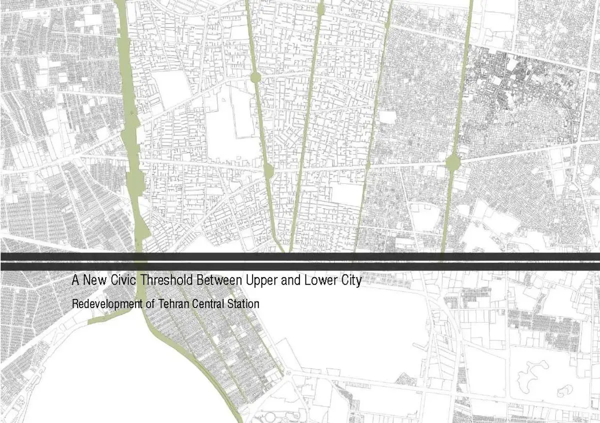
A New Civic Threshold: Reconnecting Tehran's Divided Urban Geography
Transforming Tehran's Central Station from a hard infrastructural edge into a permeable civic landscape that bridges upper and lower city.


A railway line that once stitched a nation together now cuts a city in half. Tehran's Central Station sits at the precise seam where the Alborz Mountain foothills give way to the southern plains, a topographic gradient that has, over decades, calcified into social and economic stratification. The station area, shaped by rail infrastructure and industrial functions, has become a hard edge: underused land, spatial discontinuity, and neighborhoods that turn their backs to one another. Elnaz Ghabari refuses to accept this condition as permanent. Her proposal treats the old Central Station not as a transport hub awaiting renovation but as an urban condenser capable of reconnecting ecology, mobility, and civic life across Tehran's most significant divide.
The project proposes a comprehensive regeneration framework for the Central Station precinct, repositioning it as a permeable civic threshold between the upper and lower city. Rather than designing an isolated architectural object, Ghabari builds a territorial argument: mapping blue, green, and grey infrastructural corridors across Tehran's metropolitan structure, then deploying landscape, program, and new transversal connections to transform a barrier into the city's most active public ground.
Mapping the Gradient: From Mountain to Plain
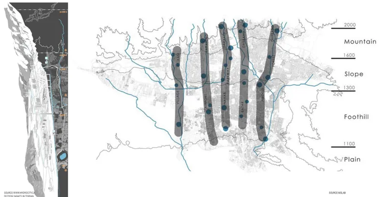
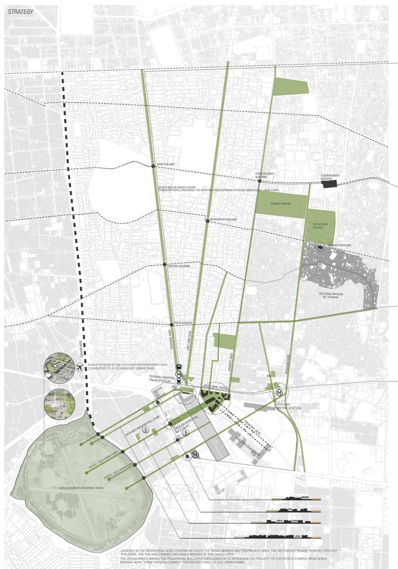
The project begins with a rigorous reading of Tehran's geography. A diagrammatic section traces the city's longitudinal profile from the Alborz range to the southern flatlands, identifying elevation zones, river corridors, and the linear vertical volumes that define Tehran's urban bands. This territorial mapping is not decorative analysis; it reveals how the railway corridor occupies the exact point of topographic transition, making the Central Station a hinge rather than a dead zone. The site plan drawing then zooms into the precinct itself, showing diagonal green corridors converging on a central development zone within the surrounding urban fabric. These corridors follow historical and environmental logics, connecting parks, residential neighborhoods, and cultural landmarks to the station area.
By reading the city as a system of overlapping infrastructures, Ghabari establishes a clear design thesis: spatial continuity must replace fragmentation. The green corridors are not afterthoughts layered onto an architectural plan; they are the organizing armature from which building, landscape, and public space emerge.
Layered Systems: Unpacking the Urban Condenser
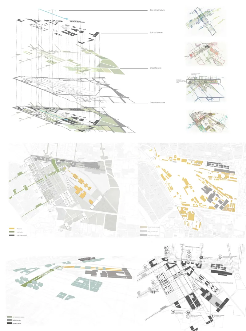
A composite drawing sheet reveals the project's internal logic through exploded axonometric layers, site plans, and isometric massing studies. Each layer isolates a different system: transport infrastructure at the base, public program and cultural facilities in the middle bands, and landscape corridors and planted terraces at the upper levels. The color coding makes legible how these systems overlap and interlock. New transversal connections bridge across rail lines, linking neighborhoods and institutions that were previously separated by the hard edge of the tracks.
The hybrid program is deliberate in its mix. Cultural spaces, community facilities, public services, and commercial functions are interwoven with transport operations to ensure the precinct remains active throughout the day. Stacking and distributing programs across different levels allows the station to function simultaneously as transit node, cultural district, and public park. Infrastructure, in this framing, becomes an active participant in urban life.
A Terraced Section That Mediates Terrain
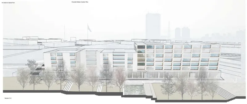
The building section cuts through a terraced volume with horizontal bands of fenestration stepping down the site's natural slope. Street trees line the foreground, establishing the ground plane as shared public territory rather than service road. The terracing is more than a formal gesture; it directly mediates the elevation change between the upper and lower city, turning what was a discontinuity into a continuous inhabitable landscape. Public plazas and green corridors are layered above and around the transport infrastructure, allowing pedestrian movement and social activity to coexist with rail operations below.
Courtyards as Climate and Memory
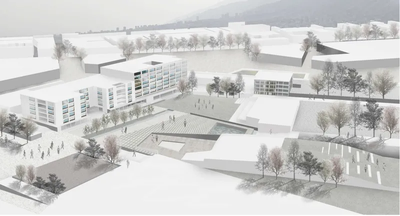
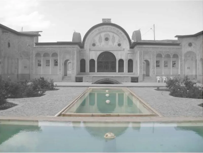
Two images capture the project's engagement with Persian spatial tradition. An aerial model view shows a sunken courtyard surrounded by low volumes and bare winter trees, a microclimate carved into the urban ground. The symmetrical courtyard facade, with its central arched portal and turquoise reflecting pools framed by planted beds, makes the reference explicit: water elements, shaded enclosures, and planted public terraces reinterpret traditional Persian principles within a contemporary metropolitan framework. These are not nostalgic citations. The landscape operates as climate moderator, social space, and connective tissue, three qualities that are essential for sustainable regeneration in Tehran's dense, arid context.
The courtyards also perform a programmatic role, anchoring civic life at the human scale within a project that spans a metropolitan territory. They create moments of stillness and encounter within a larger system of movement, ensuring that the threshold between upper and lower city is experienced not just as passage but as place.
Why This Project Matters
Cities around the world struggle with rail corridors that divide rather than connect. The temptation is to deck them over, to build a platform and pretend the infrastructure doesn't exist. Ghabari's proposal is more honest and more ambitious. By working with Tehran's topography, mapping its ecological and historical layers, and treating landscape as the primary organizing system, the project transforms a barrier into a gradient: a continuous public ground that negotiates between elevation, program, and social life.
What makes this work convincing is its refusal to separate scales. The territorial mapping informs the building section; the Persian courtyard informs the metropolitan green corridor. The Central Station becomes a civic threshold not through a single architectural gesture but through the accumulation of spatial strategies that operate from the scale of a reflecting pool to the scale of a city divided by its own geography.
View the Full Project
About the Designers
Designer: Elnaz Ghabari
Enter a Design Competition on uni.xyz
uni.xyz runs architecture and design competitions year-round that reward proposals with spatial conviction and real site intelligence.
Project credits: A New Civic Threshold Between Upper and Lower City Redevelopment of Tehran Central Station" by Elnaz Ghabari.


Popular Articles
Popular articles from the community


David Ortega Stacks a Two-Story Mexico City Penthouse Around a Steel Stair and a Pergola-Shaded Roof Terrace
In Colonia Roma, a 300 m² penthouse uses oak joinery, a planted steel stair and a slatted roof pergola to make a new-build apartment feel like a house.

Cube Design Draws an Ecological Corridor Between Two Shenzhen Hills with the Nankai Building
Beside Shenzhen's container docks, the Nankai Building pairs stacked balconies with a climbing green screen to connect two hillsides across its height.


Aquadapt: An Underwater Habitat That Rewrites Its Rooms by the Hour
Curved modules ring the seabed while one shell shifts from breakfast room to cinema, farm and football pitch as residents' needs change.

ETEH Reworks the Shared Spaces of São Domingos School in Brazil Around Timber, Color and Hanging Plants
At São Domingos School in Brazil, 436 m² of hall, refectory and library are recast with timber joinery, a yellow and blue code and trailing greenery.

Similar Reads
You might also enjoy these articles
Yenisei Monitoring Center: A Sun-and-Moon Sphere Anchors a Research Campus on Siberia's Great River
In Krasnoyarsk, shifting square blocks, a glazed central sphere and descending window rhythms turn river science into a public spectacle on the Yenisei.
Andretta Artist's Village: A Node-Based Masterplan That Lets the Hills Write the Plan
A cultural landscape strategy for Palampur's artist colony threads studios, residences and stages along a porous spine shaped by the Dhauladhar terrain.
Street Children Rehabilitation Center: A Brick Campus That Eases Children From Street to Safety
A low-rise courtyard campus where learning streets, uthans and shaded verandahs stage a gradual passage from street into protective, family-scale life.
The NEON Culture: A Field of Pavilions Built for the 24-Hour City
Smaran Alva spreads galleries, stages, clubs and markets across a varied site, treating light, sound and ramped movement as the real building materials.

Explore Transit Station Competitions
Discover active competitions in this discipline

Challenge to reimagine the Iron Throne

Photograph architecture without architects

Illustrate the lost glory of Angkor Wat - Render Challenge

Design challenge to reuse E-waste
Comments (0)
Please login or sign up to add comments
No comments yet. Be the first to comment!