
Breathing Hydrological Infrastructure: A Dam That Doubles as a Self-Sufficient Community
Sited in Bangladesh's Bandarban district, this multi-functional dam integrates housing, healthcare, education, and hydroelectric power into one living stru


A dam is typically a single-purpose object: hold back water, maybe spin a turbine. Amit Imtiaz proposes something far more ambitious. His project, Breathing Hydrological Infrastructure, reimagines the dam as a populated, multi-programmatic structure containing residences, workspaces, a school, a healthcare facility, a marketplace, and a hydroelectric power station. The dam does not merely serve a community downstream; it is the community.
Sited at Dochori Bazar Ghat in Alikadam, Bandarban, Bangladesh, the project responds to a region where mountainous terrain, river systems, and sparse infrastructure converge. The site was selected to minimize disruption to natural river flow and avoid interference with protected wildlife zones. Imtiaz draws spatial inspiration from the nearby Ali Cave, whose journey from enclosed darkness to open sky becomes a design principle: the architecture moves between containment and expression, between introversion and openness, using orientation to control ventilation and daylight.
Terrain as Structure: The Physical Model

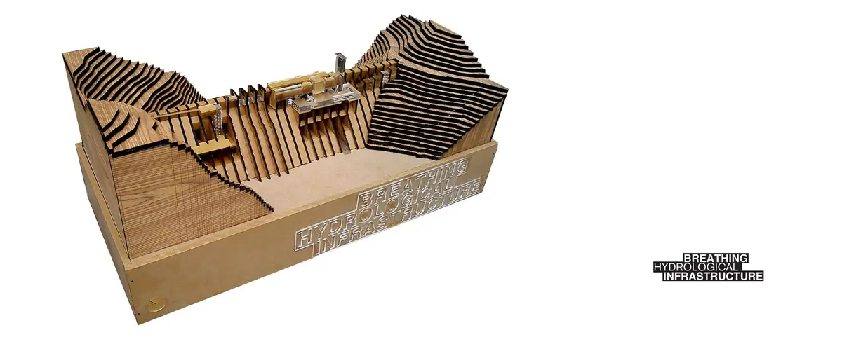
The physical model reveals the project's fundamental logic: layered timber ribs cascade down a sloped terrain, forming both the dam's structural armature and the inhabited landscape above it. Labeled program annotations mark where specific functions, from the opportunity center to the residential zones, sit within this topographic framework. What stands out is that the architecture does not sit on the hillside; it becomes the hillside, absorbing the gradient into its own section. The model makes clear that the dam wall and the community it supports share the same skeletal system.
Vertical Towers and Programmatic Stacking

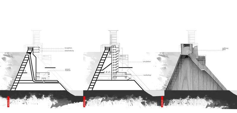
Section drawings show four distinct tower configurations, each with a different programmatic stack rendered in watercolor shadow. These vertical elements punctuate the horizontal dam body, serving as circulation cores and housing discrete institutional programs: healthcare, education, marketplace, and workspace. The variation between tower profiles suggests that each responds to its specific functional load rather than repeating a single template. This is not modular repetition for efficiency's sake; it is calibrated differentiation.
A second sequence of section drawings walks through the construction phasing, from bare framework to completed concrete tower with sloped base. The progressive buildup illustrates how the structure is meant to be realized incrementally, an important consideration in a remote mountainous site where logistics alone could derail a conventional megastructure. The phased approach also hints at the project's adaptive ambitions: components can be occupied before the whole is finished, allowing the community to form as the building grows.
A Horizontal Datum with Vertical Punctuation

The elevation drawing stretches the full length of the infrastructure into a single horizontal reading. Vertical circulation towers rise at intervals, connected by suspended cable elements that create a taut, almost bridge-like quality across the composition. The long horizontal datum is the dam itself, and the towers anchor the inhabited programs above the waterline. Cables likely contribute both structural tension and the visual impression of interconnectedness, tying the disparate programmatic towers into a coherent civic entity. The drawing reads as a new kind of urban skyline: not a city on flat ground, but a city on a wall of water.
Angled Fins and Terraced Volumes on the Hillside

The axonometric drawing pulls the project apart to reveal its spatial organization on the hillside. Angled structural fins march across the slope, creating a rhythm of terraced interior volumes that step down toward the reservoir. These fins serve a dual role: they are the load-bearing ribs of the dam and the spatial dividers for the community above. The drawing makes legible how enclosure and openness coexist, recalling the Ali Cave analogy. Some volumes are deeply sheltered between fins; others open outward to the sky, allowing daylight and cross-ventilation to penetrate the inhabited sections. The result is a gradient of privacy and exposure that mirrors the cave's own spatial drama.
Why This Project Matters
Most infrastructure projects treat human habitation as an externality: build the dam, relocate the village, pipe the electricity elsewhere. Imtiaz flips this relationship by embedding the community inside the infrastructure itself. The dam generates hydroelectric power for its own residents, the marketplace sits within walking distance of the homes, and healthcare and education are not afterthoughts but co-located programs. It is an argument for infrastructure as urbanism, where the engineering and the social fabric are one system.
The project also offers a provocative challenge to how we think about scale in remote regions. Bandarban's mountainous terrain makes conventional urban planning impractical. By concentrating civic programs within a single hydrological structure, Imtiaz proposes a compact, self-sufficient settlement type that works with the topography rather than flattening it. Whether or not every detail resolves at a technical level, the proposition is bold and worth debating: can a dam be a neighborhood? Can infrastructure breathe?
View the Full Project
About the Designers
Designer: Amit Imtiaz
Enter a Design Competition on uni.xyz
uni.xyz runs architecture and design competitions year-round that reward proposals with spatial conviction and real site intelligence.
Project credits: Breathing Hydrological Infrastructure by Amit Imtiaz.


Popular Articles
Popular articles from the community


FCC Arquitectura Expands a Portuguese Granite House with a Board-Marked Concrete Wing
In Portugal, JV House pairs a cleaned-up whitewashed and granite dwelling with a timber-shuttered concrete extension, courtyards and a garden pool.


Aquadapt: An Underwater Habitat That Rewrites Its Rooms by the Hour
Curved modules ring the seabed while one shell shifts from breakfast room to cinema, farm and football pitch as residents' needs change.

David Ortega Stacks a Two-Story Mexico City Penthouse Around a Steel Stair and a Pergola-Shaded Roof Terrace
In Colonia Roma, a 300 m² penthouse uses oak joinery, a planted steel stair and a slatted roof pergola to make a new-build apartment feel like a house.
Singing Woman: An Opera House That Performs Before the Curtain Rises
Ovidiu Cristian Pavel's conceptual opera house translates Estonia's choral identity into a sculpted waterfront landmark facing the Baltic Sea.

Similar Reads
You might also enjoy these articles

Vereda Arquitetos Renovates a 40-Square-Meter Apartment Inside Niemeyer's Copan Building
A compact unit in São Paulo's most iconic residential tower gets a material overhaul that pairs exposed concrete with bold blue Formica.

Shakur's House: Exposed Brick as an Interior Organiser in a 168 m² Mashhad Residence
Brick moves indoors in this Mashhad residence, where masonry walls, glass partitions and teal planes sequence a compact home without closing it off.
Day and Night Park: A Time-Based Urban Newsstand in Beijing
A temporary urban newsstand in Beijing blending travel, light, and reading through poetic colors, compact form, and community-focused design.

Modernist Patio Renovation in El Masnou, Barcelona by Oliver Segura Arquitectura + Cebrià Arquitectura
Modernist patio renovation blending tradition and innovation with a movable pool, leveled floors, and Catalan materials in El Masnou.

Comments (0)
Please login or sign up to add comments
No comments yet. Be the first to comment!