
C.C.C.C: Modular Grid Infrastructure Rethinks Hong Kong's Congested Roads
A shortlisted competition entry proposes programmable road surfaces and personalized driving paths to replace traditional intersections in Hong Kong.


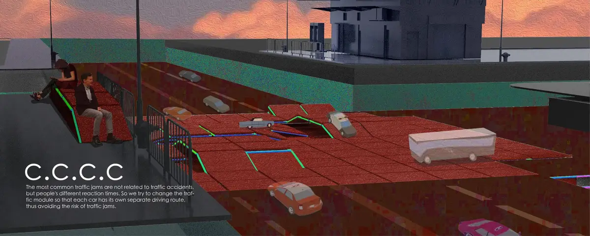
What if traffic congestion isn't really about too many cars, but about too many unpredictable human decisions happening at once? C.C.C.C starts from that premise. Rather than widening roads or adding lanes, the project eliminates the intersection altogether, replacing it with a grid-based modular platform where every vehicle is assigned a unique, conflict-free path. Sensors embedded in the pavement activate LED routing signals as cars approach, and square modules shift dynamically to accommodate real-time demand. The result is a transportation surface that behaves less like asphalt and more like programmable matter.
Designed by Yutong Zou, Summer Wang, Yuru Chen, and Yuan Lau, C.C.C.C was shortlisted in the Urbanscape: Symbiosis competition. Set in Hong Kong, the proposal confronts a city where population density, private vehicle reliance, and spatial constraints created by stacked housing and narrow streets make conventional traffic engineering increasingly futile. The designers argue that inconsistent driver reaction times, not accidents alone, are the primary trigger for congestion, and they build an entire infrastructure system around that insight.
A Plaza That Doubles as a Traffic Machine

The aerial view reveals a red-tiled plaza where roadways and pedestrian paths intersect without the chaotic overlap familiar to Hong Kong's street level. Vehicles move through designated channels while pedestrians cross freely across the surface. There are no traffic lights visible, no painted lane markings in the traditional sense. Instead, the ground itself organizes movement. The integrated electromagnetic energy system and smart signaling referenced in the proposal are doing the work that bollards, signals, and lane dividers normally do, embedded invisibly in the infrastructure.
What stands out is the ambition to reclaim surface area. In a city where every square meter carries enormous economic and social weight, a road surface that also functions as public space is not a luxury but a necessity. The plaza is not a pedestrianized zone pretending cars don't exist; it is a shared surface where technology arbitrates between modes of transport in real time.
Vertical Infrastructure for Pedestrians, Not Just Cars
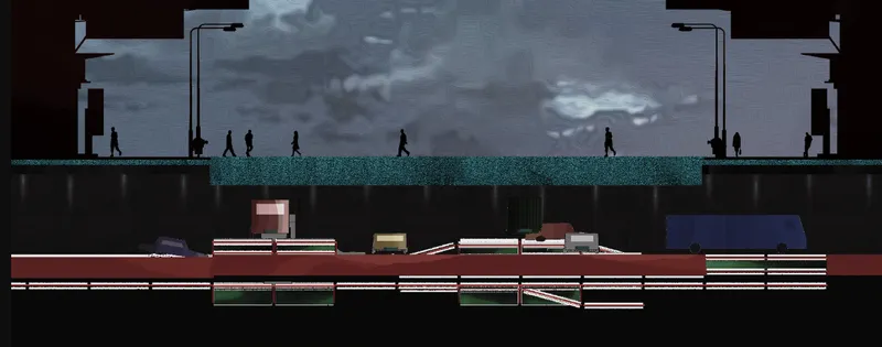
The section drawing cuts through the proposal's layered logic. An elevated pedestrian bridge spans above ground level, while underground transit levels handle heavier vehicle flows below. Walking figures populate both the bridge and the subterranean corridors, reinforcing the designers' commitment to making every vertical layer serve a human function. Rest areas, public reading zones, rainshades, and storage platforms are integrated into these vertical sections, transforming what would typically be dead infrastructure space into activated community zones.
This layered approach directly addresses one of Hong Kong's core spatial dilemmas: when you can't expand horizontally, you must think in section. By stacking pedestrian, vehicular, and civic programs, C.C.C.C ensures that roads are not barriers but connective tissue linking multiple levels of urban life. The neon-inspired design elements visible throughout the drawings root the scheme firmly in Hong Kong's visual culture while signaling a modernized function.
Mapping the Problem Before Solving It

Before proposing any new infrastructure, the team mapped Hong Kong's existing transportation networks and building typologies at a regional scale. The urban planning diagram charts the complex relationship between population density, transport systems, and spatial behavior across the territory. It makes visible what residents already know: public transport absorbs much of the load, but private vehicles continue to pressure road networks in ways the current grid cannot accommodate.
The value of this analytical layer is that it grounds the speculative technology in observable urban conditions. The modular system isn't proposed as a universal fix; it responds to specific pressure points where inconsistent driver behavior and spatial constraints create bottlenecks. Recognizable urban motifs like stacked housing and neon signage appear in the research as both cultural symbols and physical constraints that shape the design response.
Exploded Grid: How the Modular System Actually Works

The axonometric drawing is the technical heart of the proposal. It explodes the modular grid structure into its component layers, revealing the material assembly and spatial logic that make the system function. Square platform elements are shown individually, each capable of dynamic repositioning. GPS synchronization and sensor technologies coordinate vehicle routing across the grid, while the embedded LED signaling system visible in earlier drawings is shown here in its structural context.
The modular fabrication strategy is key to the proposal's scalability argument. Individual grid units can be replaced, upgraded, or reconfigured without shutting down adjacent segments. This is infrastructure designed for iteration, not permanence. In a city that reinvents its streetscape constantly, a system built from swappable components has a pragmatic appeal that monolithic road engineering lacks.
Why This Project Matters
C.C.C.C represents a shift from reactive traffic management to predictive traffic architecture. Most urban transportation design responds to congestion after it happens: adding a turn lane, adjusting signal timing, rerouting buses. This proposal intervenes at the infrastructure level, eliminating the conditions that produce congestion in the first place by removing conflict points entirely and assigning individualized vehicle paths. It is a fundamentally different design philosophy, one that treats the road surface as an active system rather than a passive substrate.
The project also raises a question that dense cities worldwide will increasingly face: can transportation infrastructure serve civic functions beyond movement? By embedding rest areas, reading zones, and storage into the vertical section of roads, the designers argue that it can and must. For Hong Kong, where space is the scarcest resource, multifunctional infrastructure is not utopian thinking. It is practical necessity. C.C.C.C makes a compelling case that the next evolution in urban mobility will not come from faster vehicles but from smarter surfaces.
View the Full Project
About the Designers
Designers: Yutong Zou, Summer Wang, Yuru Chen, Yuan Lau
Enter a Design Competition on uni.xyz
uni.xyz runs architecture and design competitions year-round that reward proposals with spatial conviction and real site intelligence.
Project credits: C.C.C.C by Yutong Zou, Summer Wang, Yuru Chen, Yuan Lau Urbanscape: Symbiosis (uni.xyz).


Popular Articles
Popular articles from the community


Play: Fragments of Their World
Familiar architecture becomes modular playground design, creating safe spaces where displaced children can learn, connect, imagine and play.

Lunar Spiral: Space Architecture Shaped by the Mathematics of the Universe
Lunar Spiral reimagines space architecture through Fibonacci geometry, lunar regolith, levitating habitats, and self-sustaining Moon living.

Co-life: Sustainable Architecture for Age-Friendly Community Living
Co-life reimagines sustainable architecture for seniors through courtyards, rammed earth, shared gardens, and spaces designed for belonging.
Hill & Cross Opera: Sculptural Opera House Architecture Shaped by Tallinn’s Landscape and Identity
Hill & Cross Opera reimagines opera house architecture in Tallinn through its sculptural hill, civic plaza, glass wave and a luminous cross.

Similar Reads
You might also enjoy these articles

Day and Night Park: A Time-Based Urban Newsstand in Beijing
A temporary urban newsstand in Beijing blending travel, light, and reading through poetic colors, compact form, and community-focused design.

Modernist Patio Renovation in El Masnou, Barcelona by Oliver Segura Arquitectura + Cebrià Arquitectura
Modernist patio renovation blending tradition and innovation with a movable pool, leveled floors, and Catalan materials in El Masnou.
Alto Residencial Coop: Cooperative Housing Development in Santiago de Compostela by Carbajo Barrios Arquitectos
A linear cooperative housing complex blending white volumes and perforated metal façades, enhancing community living, natural light, privacy, and urban integration.
Vil Genis School by BPA ARCHITECTURE – Massy, France
Vil Genis School in Massy, France, features sustainable design, south-facing classrooms, community integration, accessible spaces, and modern educational architecture.

Comments (0)
Please login or sign up to add comments
No comments yet. Be the first to comment!