

Placemaking Along Hubballi's Water Streams: Reclaiming River Corridors as Urban Commons
A strategic planning framework transforms Hubballi's degraded Karkihalla stream corridor into a network of ecological and social public spaces.


When a river running through a city becomes invisible, the loss is never just environmental. It is spatial, social, and deeply cultural. In Hubballi, Karnataka, the Karkihalla stream, which originates from Unkal Lake, has undergone precisely this transformation: from a source of sustenance, ritual, and everyday public life to what Roger Trancik would call a "lost space," a residual urban void encroached by informal housing, polluted by industrial waste, and severed from public access. The question this project asks is whether architecture and landscape design, deployed strategically at the city scale, can reverse that erasure.
Anita Jakkappanavar's thesis, Placemaking Along Hubballi's Water Streams, proposes a comprehensive regeneration framework for the degraded river corridors of Hubballi–Dharwad. Situated at the edge of the Western Ghats and the Deccan Plateau in North Karnataka, the city evolved historically through a close relationship with its blue and green networks: lakes, tanks, canals, and seasonal streams that structured agriculture, trade, and daily life. The project positions water not as mere infrastructure but as a socio-cultural armature capable of re-stitching fragmented urban fabrics, aligning architecture, landscape, and urban design within a single coherent strategy.
A City Split by Its Own River: Reading History Through Water
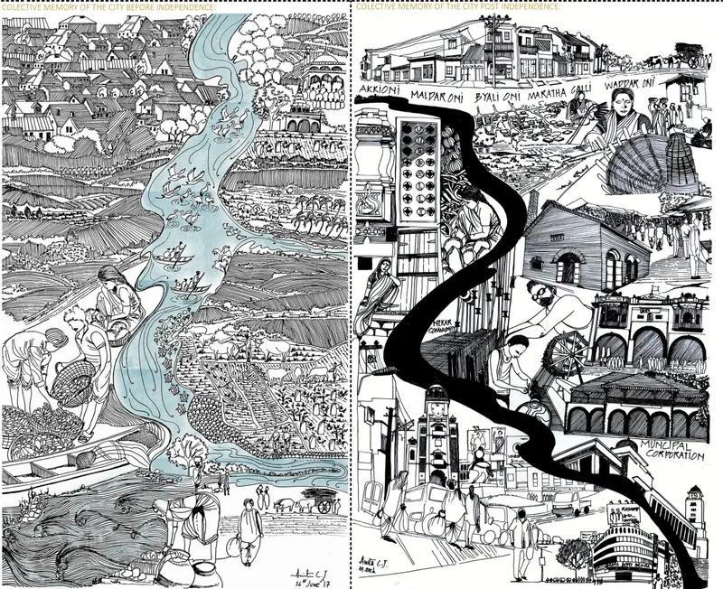
The illustrated elevation drawing above captures the project's conceptual starting point with striking clarity. A black river bisects the composition, with historical and urban scenes rendered in line art and watercolor on either side. The technique is intentional: it visualizes the rupture between Hubballi's pre-independence relationship with water, when edges supported festivals, markets, washing ghats, and agriculture, and the post-independence condition, where industrialisation, land commodification, and infrastructure-led growth severed that bond. Through hand-drawn illustrations and narrative mapping, Jakkappanavar builds a case grounded in collective memory, arguing that the cultural significance of water edges must be understood before they can be spatially reclaimed.
The drawing also signals the project's methodological commitment. Rather than beginning with a design proposal, the thesis layers temporal analysis: how policy decisions, economic priorities, and urbanisation patterns reshaped Hubballi's drainage networks over decades. Porous landscapes were replaced by impervious surfaces. Natural drainage gave way to engineered channels. The spatial contradictions between planned urban layouts and organic river morphology intensified flooding, ecological degradation, and socio-spatial exclusion. The drawing distills all of this into a single legible image.
Mapping Degradation: From Regional Hydrology to Street-Level Conditions
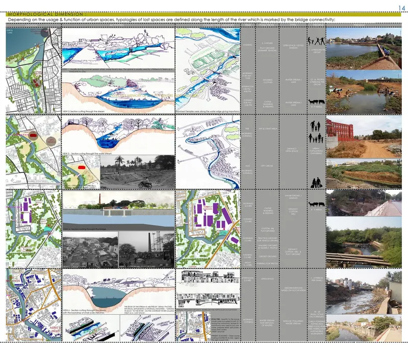
The analytical board combines site plans, watercolor sections, photographs, and diagrammatic studies to document existing waterfront and infrastructure conditions along the Karkihalla corridor. What makes this sheet valuable is its scalar range. The study extends beyond the city to examine Hubballi's position within a larger regional water system. Rivers such as the Bedthi (Gangavali) and Kali and their tributaries connect inland landscapes to the Arabian Sea, forming continuous ecological corridors across districts. Lakes like Unkal, Nuggikeri, and Neersagar act as critical nodes. By mapping these hydrological connections, the project frames urban riverfront regeneration not as an isolated design gesture but as part of a broader ecological strategy, where disruptions at the city level reverberate across regions, affecting biodiversity, groundwater recharge, and agricultural productivity.
At the local scale, the board documents the condition of lost spaces along the stream: vacant land, degraded edges, abandoned infrastructure, and disconnected pedestrian networks. Photographs of encroachment and pollution sit alongside sectional drawings that reveal the gap between existing conditions and potential. The analytical rigor here is the project's backbone; every subsequent design decision is traceable to this body of evidence.
The Corridor as Armature: Axonometric Studies of River Edge Urbanism
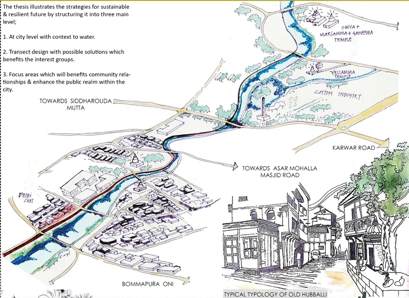
The ink and watercolor axonometric drawing pulls back to reveal the river corridor as a continuous linear system rather than a series of isolated sites. Bridges, buildings, and vegetation are depicted in spatial relationship to the water, establishing the stream as the organizing spine around which public life can reconvene. The axonometric view is well chosen: it communicates both plan logic and vertical relationships simultaneously, showing how building massing, canopy cover, and pedestrian circulation can negotiate the transition between urban fabric and water edge.
Critically, the drawing suggests a design language that works with the organic morphology of the stream rather than imposing rigid geometric order. The corridor bends and widens. Vegetation clusters follow topographic logic. Buildings step back at varying distances from the edge. The effect is a proposal that reads as landscape-led urbanism, where the ecological armature dictates spatial form, not the other way around.
Stepped Terraces and Waterfront Promenades: Inhabiting the Edge
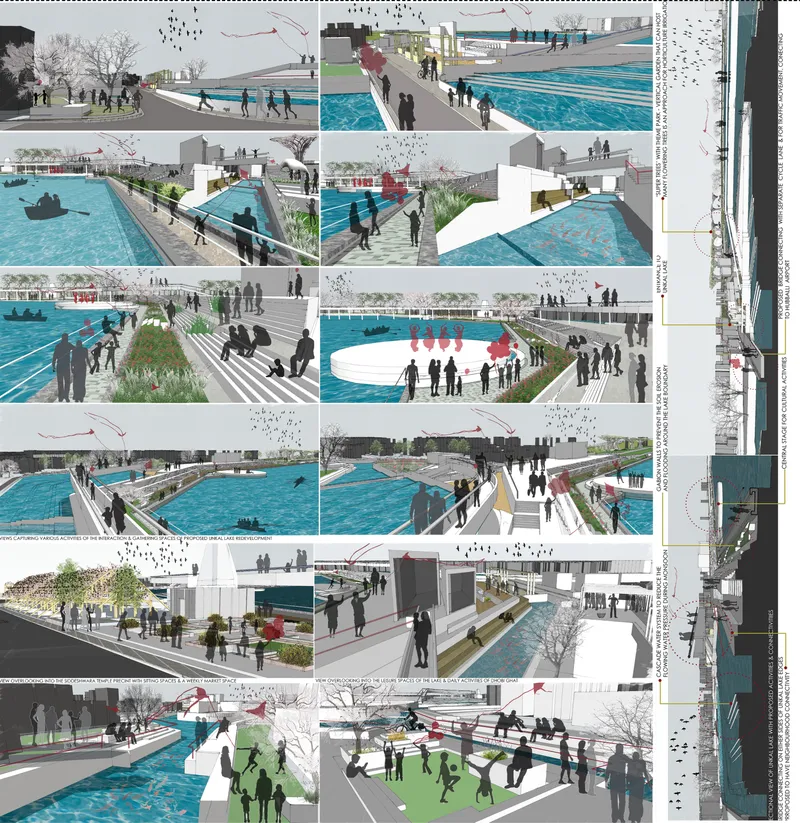
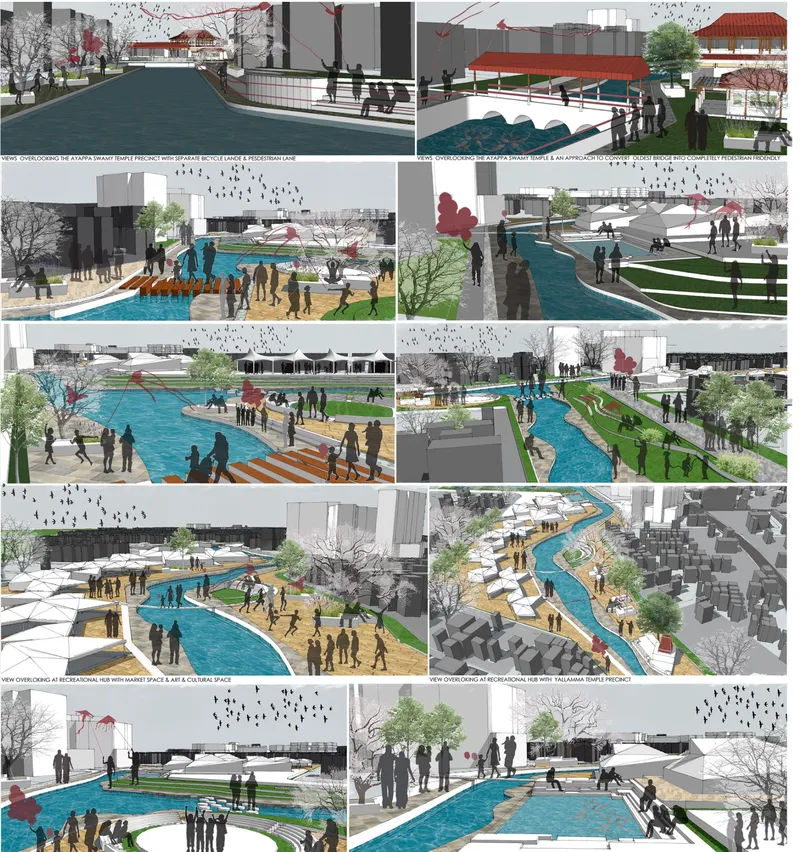
The rendered perspectives bring the proposal to human scale. Stepped terraces descend toward the canal, creating seating and gathering spaces that echo the function of traditional washing ghats while serving contemporary public life. Waterfront promenades accommodate pedestrians alongside planted edges, and the views consistently emphasize the social dimension: people are present, walking, sitting, gathering near the water. Timber decks extend over planted edges, softening the boundary between path and stream.
These images represent the project's answer to the lost spaces identified in the analysis phase. Where vacant land and degraded edges once alienated residents from the water, the proposal introduces programmed public surfaces that invite occupation. Trees provide shade canopy. Stepped sections manage stormwater while creating amphitheater-like social spaces. The design vocabulary is restrained, relying on material honesty (timber, stone, planting) and section-driven spatial quality rather than formal spectacle. The result is a series of water-edge commons that feel plausible for a mid-sized Indian city, not imported from a European precedent.
Massing the Framework: Aerial Views of a Regenerated Corridor
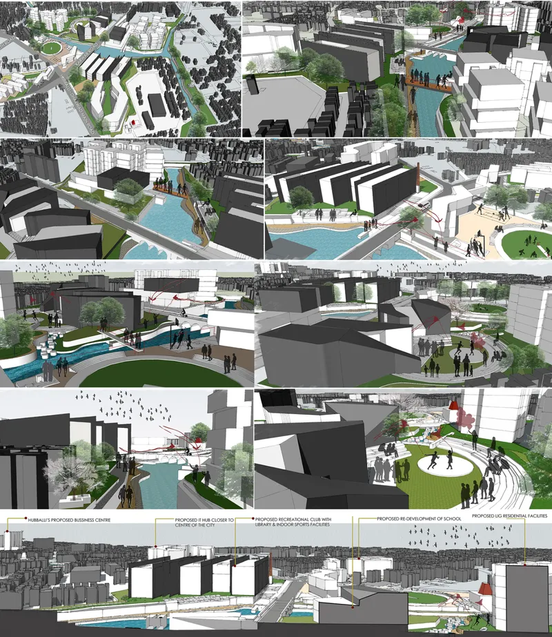
The three-dimensional massing studies provide aerial views of proposed buildings, waterways, and landscaped public spaces along the regenerated corridor. Viewed from above, the strategy becomes legible as a network: a sequence of built and open nodes connected by the continuous thread of the stream. Building footprints vary in scale and orientation, suggesting mixed-use programming that could support the livelihoods and activities historically associated with water edges. Landscaped buffers between development and water maintain ecological function while framing visual and physical access to the stream.
The massing is deliberately non-prescriptive at the architectural level. Individual buildings are shown as volumes, not resolved facades, signaling that the project operates as a strategic planning framework rather than a finished architectural proposal. This is an honest and appropriate position for the scope of the thesis: the value lies in the systemic thinking, the layered analysis, and the spatial principles that could guide incremental development along the corridor over time.
Why This Project Matters
Hundreds of mid-sized Indian cities share Hubballi's condition: water systems that once organized settlement have been reduced to neglected backyards. The pressure to respond with hard-engineered flood infrastructure or cosmetic beautification is immense, and both approaches tend to fail because they treat symptoms rather than the underlying spatial and cultural disconnection. Jakkappanavar's project is significant because it refuses that shortcut. It begins with temporal analysis and collective memory, builds a regional ecological framework, and only then proposes spatial interventions calibrated to street-level conditions.
The thesis also models an approach to design research that is increasingly necessary in Indian urbanism: one that moves fluidly between scales (regional watershed to timber deck detail), between disciplines (hydrology, cultural geography, landscape architecture, urban design), and between analytical and propositional modes. The hand-drawn and watercolor language throughout is not mere stylistic preference; it reinforces the idea that these water corridors are living, evolving systems, not static engineering problems. For cities like Hubballi, the argument is clear: reclaiming the river is not a luxury. It is a strategic imperative for ecological resilience, social equity, and the recovery of urban identity.
View the Full Project
About the Designers
Designer: Anita Jakkappanavar
Enter a Design Competition on uni.xyz
uni.xyz runs architecture and design competitions year-round that reward proposals with spatial conviction and real site intelligence.
Project credits: PLACE - MAKING ALONG HUBBALLI'S WATER STREAM-A STRATEGIC PLANNING APPROACH by Anita Jakkappanavar.


Popular Articles
Popular articles from the community

Cloaked Colonization: A Mobile Underwater Habitat That Moves Like a Fish
Micah Abaya's shortlisted EHC Pacific entry reimagines ocean settlement as a dispersed network of self-sustaining architectural organisms.
Extended Shell: Retrofitting Kolkata's Balconies as Living Urban Thresholds
A modular retrofit system recovers the social and environmental intelligence of Kolkata's historic verandas for contemporary Park Street residents.
Faces of the Soviet Avant-Garde: Turning Moscow's Street Names into an Open-Air Museum
A network of sculptural installations across a Moscow residential district transforms forgotten architect names into spatial encounters with cultural memor
Tsunami Convergenics: Turning Catastrophic Ocean Forces into Underwater Housing Infrastructure
A speculative underwater settlement off the coast of Onagawa, Japan, treats tsunamis and typhoons as energy sources rather than threats.

Similar Reads
You might also enjoy these articles
Sustainable Architecture Design: Embracing Nature and Modernity at Villa Solsidan
The article explores Villa Solsidan by AndrénFogelström, showcasing its sustainable architecture design and integration with the natural surroundings in Saltsjöbaden, Sweden.
Scientific and Educational Monitoring Center of the Yenisei, Krasnoyarsk
Architecture as an instrument for ecological research, education, and environmental awareness along Russia’s largest river.
Development of Andretta Artist’s Village, Palampur, Himachal Pradesh, India
Reimagining Andretta as a living cultural landscape where art, architecture, and community converge to shape a global creative village.
Street Children Rehabilitation Center: A Model of Social Architecture for Community Rehabilitation
An inclusive social architecture project that transforms streets into nurturing environments, restoring dignity, identity, and opportunity for vulnerable children.

Comments (0)
Please login or sign up to add comments
No comments yet. Be the first to comment!