

Aniene River Blue-Green Infrastructure: Turning Rome's Flood Risk into Public Landscape
A 650-hectare landscape strategy along Rome's Aniene River transforms flood events into ecological corridors, retention basins, and civic space.


What if a city stopped fighting its floods and started designing with them? Along the lower course of Rome's Aniene River, one of the capital's most fragile and overlooked waterways, a landscape-led proposal does exactly that. Rather than armoring riverbanks with concrete, the project reworks the river's morphology through retention basins, floodable ditches, riverbed expansion zones, and riparian buffers, turning extreme precipitation events into spatial experiences and ecological processes that serve the city year-round.
Designed by Marco Nelli, the project spans approximately 650 hectares along the Aniene's final stretch before it meets the Tiber. Published on uni.xyz, the proposal positions blue-green infrastructure as the primary architectural and landscape strategy for a corridor choked by dense urbanization, impermeable surfaces, and fragmented ecological systems. It is a deliberate reframing: flooding here is not a failure to be engineered away, but a dynamic environmental process to be integrated into the spatial and social life of Rome.
Mapping Water Risk as a Design Tool
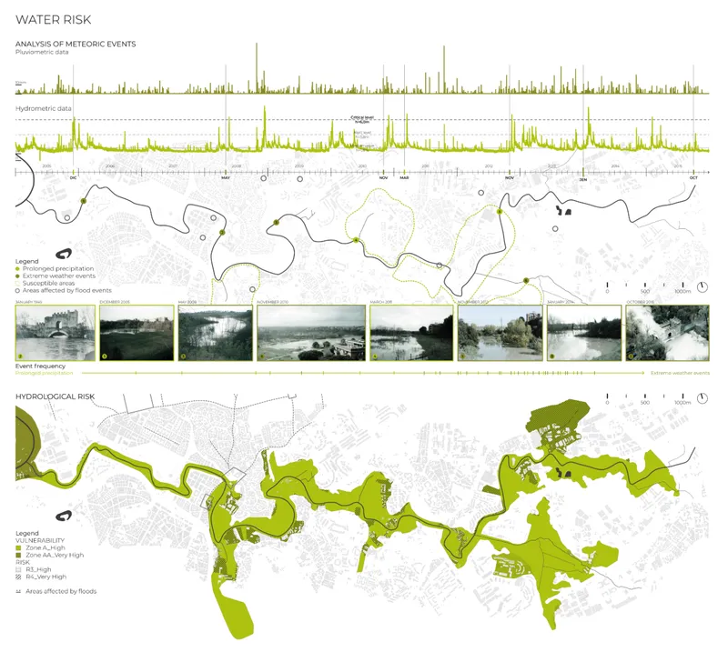
The project begins not with form but with data. Detailed pluviometric and hydrometric analyses map prolonged precipitation events, critical water levels, and flood-prone zones across the Aniene basin. The analytical drawing above layers precipitation graphs, site photographs, and hydrological risk mapping to establish a precise spatial reading of vulnerability. These data-driven mappings become the generative logic of the design: instead of a single defensive line, the strategy distributes water absorption capacity across the entire corridor, accommodating hydrological variability rather than resisting it through rigid engineering alone.
Rome, like many historic European cities, faces escalating exposure to extreme precipitation, soil erosion, and rising temperatures. The Aniene basin concentrates all of these risks in a corridor where impervious urban fabric meets a river system with diminishing room to breathe. By treating the risk map as a design brief, Nelli grounds every subsequent spatial decision in measurable environmental conditions.
Riparian Vegetation as Operative Infrastructure
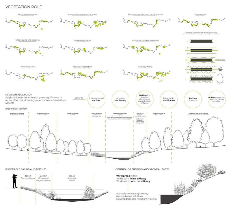
Vegetation in this project is not decorative. It is infrastructure. The diagram above dissects the roles of riparian planting through plan maps, section drawings, and flood control strategies, showing how distinct vegetative zones correspond to specific hydrological behaviors. Flood-sensitive areas, naturalistic conservation zones, riverbank erosion control strips, urban parks, recreational meadows, and productive cultivated fields each receive species selections calibrated to stabilize soils, filter pollutants, regulate microclimates, and support biodiversity.
What makes this approach convincing is its insistence on specificity. Each zone delivers measurable technical performance (bank stabilization, pollutant filtration) while simultaneously creating habitable, shaded public spaces. The vegetation network strengthens ecological continuity along the corridor, reconnecting fragments of habitat that decades of urbanization have severed. It is landscape doing the work that engineered walls and pipes typically monopolize, but with far greater ecological and social return.
A 650-Hectare Masterplan of Connected Landscape Episodes
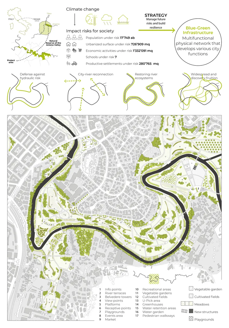
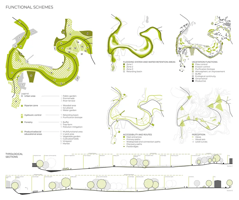
The masterplan refuses the idea of a singular park. Instead, it structures the 650-hectare corridor as a sequence of connected landscape episodes, each responding to local conditions while remaining part of a cohesive territorial system. The plan drawing reveals how curved river corridors and green infrastructure weave into the existing urban fabric and street grid, while the functional scheme diagrams below break down serpentine landscape zones into numbered program areas with corresponding typological sections.
Key design actions include riverbed expansion and overflow basins to reduce downstream flood pressure, riparian system recovery to stabilize banks and improve water quality, buffer zones mediating between industrial, residential, and ecological areas, and discovery paths that reconnect citizens to the river through slow mobility routes. This layered approach means the park functions differently across seasons, water levels, and patterns of use. During peak events, retention areas absorb floodwater; during dry months, those same areas become accessible meadows and gathering grounds. The Aniene transforms from a residual urban edge into a productive civic spine.
Forestry Strategy and Canopy Architecture
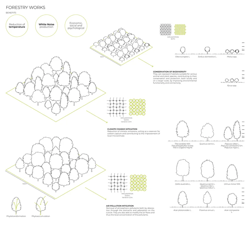
The isometric diagrams above detail forestry strategies at the scale of individual tree canopies, planting grids, and species elevations. This level of resolution matters. Climate mitigation in a Mediterranean city depends on canopy density, species selection, and spatial arrangement, not just square meters of green. The drawings show how different planting configurations address microclimate regulation, stormwater interception, and habitat creation simultaneously, reinforcing the project's argument that vegetation must be designed with the same rigor applied to any structural system.
Why This Project Matters
The strength of Nelli's proposal lies in its refusal to separate infrastructure from landscape, or environmental performance from public life. Too many urban resilience projects default to either hard engineering (walls, channels, pumps) or soft aesthetics (green roofs, rain gardens as ornament). The Aniene River strategy operates in the productive territory between the two, deploying vegetation, topography, and hydrology as a single integrated system that delivers flood mitigation, ecological regeneration, and civic space at a territorial scale.
At 650 hectares, the ambition is real. But so is the specificity: pluviometric data, species palettes, hydrological sections, and program diagrams anchor every design move in verifiable site conditions. For Rome, a city whose relationship with its rivers has always been fraught, the project offers a working model of how blue-green infrastructure can transform a neglected corridor into a resilient, inhabitable landscape. It is a compelling argument that the next generation of urban parks should be designed not despite climate risk, but because of it.
View the Full Project
About the Designers
Designer: Marco Nelli
Enter a Design Competition on uni.xyz
uni.xyz runs architecture and design competitions year-round that reward proposals with spatial conviction and real site intelligence.
Project credits: Climate Change & Urban Resilience / A New Urban Park Along the Final Stretch of the Aniene River in Rome by Marco Nelli.


Popular Articles
Popular articles from the community

Faces of the Soviet Avant-Garde: Turning Moscow's Street Names into an Open-Air Museum
A network of sculptural installations across a Moscow residential district transforms forgotten architect names into spatial encounters with cultural memor
Manzana Morphosis: Stretching Barcelona's Grid into a Living Landscape for 2050
A radical reworking of the Eixample manzana turns density into a tool for generous public space, vertical ecology, and environmental performance.
Opera on the Sea: Driftwood Logic Shapes a Timber Opera House on Estonia's Coast
Trevor Orgill's opera house translates the entangled drift of floating timber into a civic building where wood, water, and music converge.
Extended Shell: Retrofitting Kolkata's Balconies as Living Urban Thresholds
A modular retrofit system recovers the social and environmental intelligence of Kolkata's historic verandas for contemporary Park Street residents.

Similar Reads
You might also enjoy these articles
Sustainable Architecture Design: Embracing Nature and Modernity at Villa Solsidan
The article explores Villa Solsidan by AndrénFogelström, showcasing its sustainable architecture design and integration with the natural surroundings in Saltsjöbaden, Sweden.
Scientific and Educational Monitoring Center of the Yenisei, Krasnoyarsk
Architecture as an instrument for ecological research, education, and environmental awareness along Russia’s largest river.
Development of Andretta Artist’s Village, Palampur, Himachal Pradesh, India
Reimagining Andretta as a living cultural landscape where art, architecture, and community converge to shape a global creative village.
Street Children Rehabilitation Center: A Model of Social Architecture for Community Rehabilitation
An inclusive social architecture project that transforms streets into nurturing environments, restoring dignity, identity, and opportunity for vulnerable children.

Explore Urban Resilience Competitions
Discover active competitions in this discipline

Challenge to reimagine the Iron Throne

Photograph architecture without architects

Illustrate the lost glory of Angkor Wat - Render Challenge

Design challenge to reuse E-waste
Comments (0)
Please login or sign up to add comments
No comments yet. Be the first to comment!