
Placemaking Along Hubballi’s Water Streams: An Urban Riverfront Regeneration Strategy
Reimagining Hubballi’s forgotten water corridors through urban riverfront regeneration to restore ecology, culture, and public life.
Urban riverfront regeneration has emerged as a critical architectural and planning strategy in rapidly transforming Indian cities. As urbanisation accelerates, natural water systems that once structured settlement, culture, and ecology are increasingly reduced to infrastructural backyards. Placemaking Along Hubballi’s Water Stream – A Strategic Planning Approach, a project by Anita Jakkappanavar, investigates this condition in Hubballi–Dharwad, Karnataka, proposing a comprehensive framework to reclaim degraded river corridors as active urban commons.
The project "PLACE - MAKING ALONG HUBBALLI'S WATER STREAM-A STRATEGIC PLANNING APPROACH" positions water not merely as an environmental resource, but as a socio-cultural armature capable of re-stitching fragmented urban fabrics. By addressing ecological degradation, spatial discontinuity, and loss of collective memory, the proposal aligns architecture, landscape, and urban design within the broader discourse of urban riverfront regeneration.
City, Water, and Cultural Memory
Hubballi, located in the Dharwad district of North Karnataka, sits at the edge of the Western Ghats and the Deccan Plateau. Historically, the city evolved in close association with its green and blue networks—lakes, tanks, canals, and seasonal streams that shaped agricultural practices, trade, and everyday life. These water systems functioned as urban commons, supporting livelihoods, cultural rituals, and ecological balance.
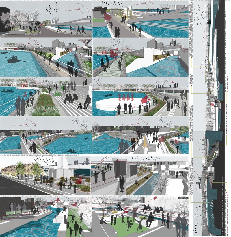
Over time, industrialisation, land commodification, and infrastructure-led growth disrupted this symbiotic relationship. Water edges that once acted as social condensers gradually transformed into zones of neglect—encroached upon by informal housing, polluted by industrial waste, and disconnected from public access. The Karkihalla stream, originating from Unkal Lake, exemplifies this shift, transitioning from a source of sustenance to a residual urban void.
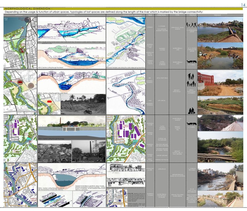
Lost Spaces and Urban Fragmentation
Central to the thesis is the concept of “lost spaces,” as described by Roger Trancik—ill-defined urban areas that contribute little to the public realm yet hold immense latent potential. Along Hubballi’s river corridors, these lost spaces manifest as vacant land, degraded edges, abandoned infrastructure, and disconnected pedestrian networks.
Rapid urbanisation altered natural drainage patterns, replacing porous landscapes with impervious surfaces. The resulting spatial contradictions—between planned layouts and organic river morphology—have intensified flooding, ecological degradation, and socio-spatial exclusion. The project critically maps these transformations across temporal layers, revealing how policy decisions and economic priorities reshaped the city’s relationship with water.
Regional Water Systems and Ecological Networks
The study extends beyond the city scale to examine Hubballi’s position within a larger regional water system. Rivers such as the Bedthi (Gangavali), Kali, and their tributaries connect inland landscapes to the Arabian Sea, forming continuous ecological corridors across districts. Lakes like Unkal, Nuggikeri, and Neersagar act as critical nodes within this network.
By mapping these hydrological connections, the project highlights the interdependence between urban centres and their surrounding ecologies. Disruptions at the city level reverberate across regions, affecting biodiversity, groundwater recharge, and agricultural productivity. Urban riverfront regeneration, therefore, is framed not as an isolated design intervention but as part of a broader ecological strategy.
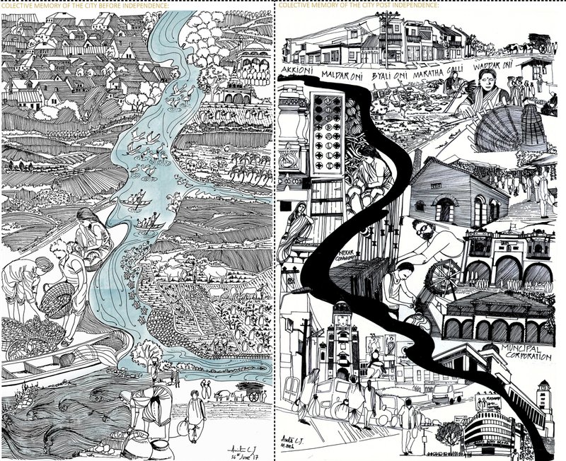
Collective Memory and Water Edges
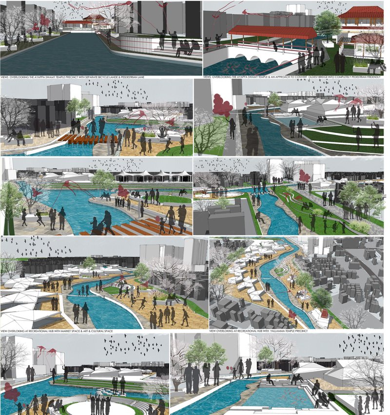
A distinctive aspect of the proposal is its focus on collective memory. Through hand-drawn illustrations and narrative mapping, the project contrasts the pre-independence and post-independence relationship between the city and its water systems. Earlier, water edges supported festivals, markets, washing ghats, agriculture, and everyday social interaction. Today, these same edges are marked by exclusion, pollution, and infrastructural barriers.
Reintroducing water into the urban imagination becomes a placemaking tool—one that reconnects people to landscape through cultural production of space. Temples, gardens, pedestrian paths, and community-oriented programs are envisioned as mediators between built form and natural systems.
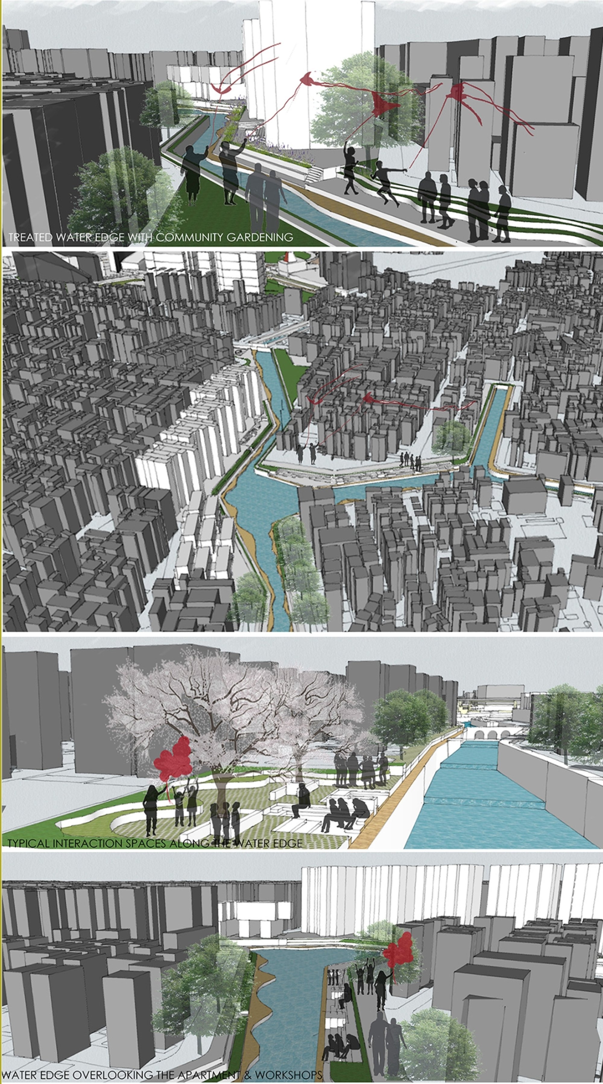
Placemaking as Urban Riverfront Regeneration
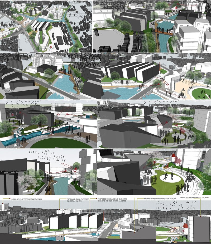
The core architectural proposition lies in redefining the river corridor as a continuous public realm. Rather than treating the stream as a boundary, the project reframes it as a connective spine—linking neighbourhoods, institutions, and open spaces. Strategies include:
- Reinforcing green and blue networks as ecological corridors
- Transforming vacant river-edge land into accessible public spaces
- Integrating pedestrian and non-motorised movement systems
- Embedding cultural, recreational, and productive landscapes
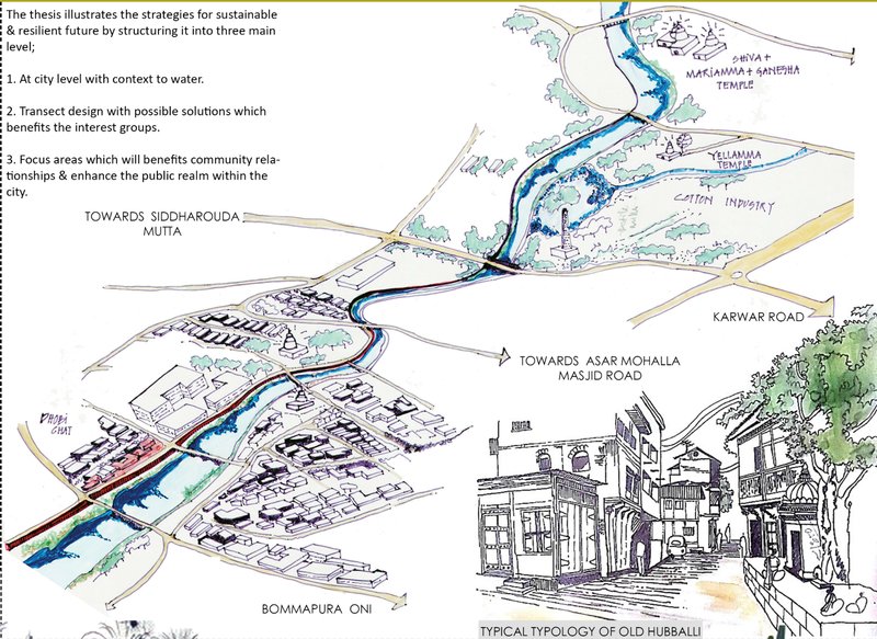
These interventions operate across multiple scales—city level, neighbourhood level, and water-edge level—ensuring spatial continuity and ecological resilience. Water is repositioned as an asset capable of driving social inclusion, environmental repair, and economic vitality.
Toward a Resilient Urban Future
As climate change intensifies flooding, heat stress, and resource scarcity, cities like Hubballi must re-evaluate their relationship with natural systems. This thesis demonstrates how urban riverfront regeneration can serve as a resilient planning model—one that integrates ecological processes with human experience.
By transforming neglected water streams into active urban commons, the project proposes a future where architecture and landscape work together to restore balance between city and nature. Placemaking Along Hubballi’s Water Streams stands as a compelling example of how strategic planning and design can reclaim lost spaces, revive collective memory, and shape more sustainable and inclusive cities.
Project by: Anita Jakkappanavar


Popular Articles
Popular articles from the community
Split House: A Compact Urban Home Blending Privacy, Light, and Flexible Living in Japan
Compact Japanese home featuring DOMA space, flexible café potential, passive lighting, privacy zoning, and sustainable urban living design.
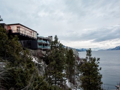
Alton Cliff House: A Harmonious Retreat by f2a Architecture in Lake Country, Canada
Alton Cliff House blends corten steel, prefabrication, and sustainable design, creating a luxurious, energy-efficient retreat perched on Canadian cliffs.
Filtering Space: A Gradual Spatial Experience
From urban intensity to spatial calm.
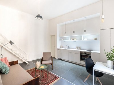
Marvila Apartment Renovation in Lisbon: A Bright Minimalist Attic Transformation by KEMA Studio
Bright attic transformed into minimalist Lisbon apartment with skylights, sustainable materials, open plan layout, and industrial-inspired interior design elements.


Similar Reads
You might also enjoy these articles
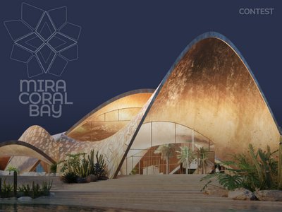
Architectural Competition: Create a Luxury Waterfront Community in the UAE!
Mira Developments announces an open competition for the pre-concept design of Mira Coral Bay in Ras Al Khaimah, UAE
Parametric Design: What Can You Learn from the 1st Workshop of Beegraphy?
Discover the Fundamentals and Advanced Techniques of Parametric Design
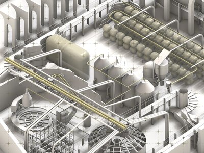
Feast of flight factory
A new ecological order with sustainable food resources-insects
Beyond Blueprints : How Architecture Presentation Boards Define The Design Narratives?
Unveiling the Art and Strategy Behind Architectural Storytelling


Comments (0)
Please login or sign up to add comments
No comments yet. Be the first to comment!