

Ningbo's Abandoned Railway Becomes a 987-Meter Linear Park Threaded Beneath Active Tracks
A century-old rail corridor in Wuxiang Town is rewoven into public space connecting village, metro, and future development.
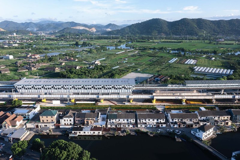
The Xiaoyong Railway was built in 1910. The Ningbo Metro Line 1 opened in 2014. Between those two dates lies a century of infrastructure piled onto a single corridor in Wuxiang Town, Yinzhou District, where an abandoned ground-level branch line, an active elevated railway, and a metro station now exist in parallel. Ningbo Urban Construction Design and Research Institute took this compressed strip of redundant and active rail infrastructure and turned it into the Wuxiang 987 High Line Park: a 987-meter-long public landscape that occupies the residual space between tracks, roads, a river, and the grain of an existing village.
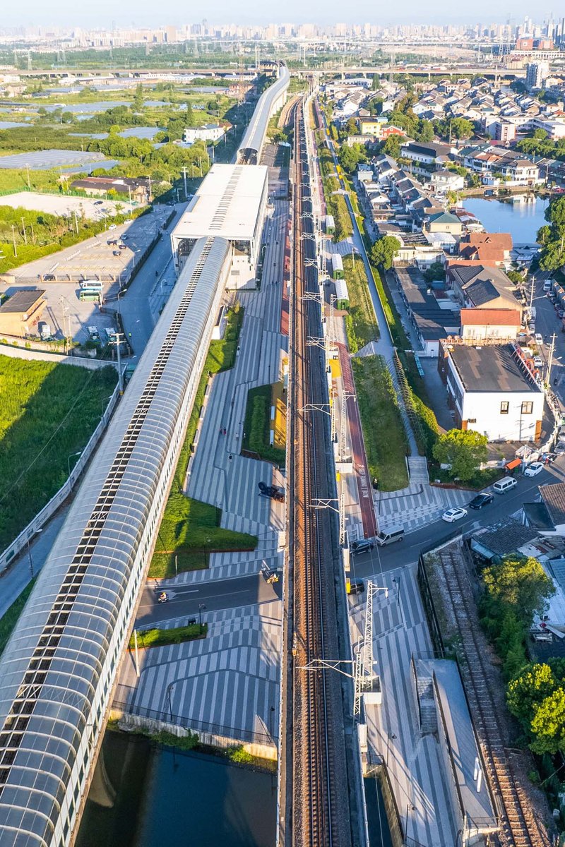
What makes this project genuinely interesting is not just the transformation of a disused rail line (a familiar playbook by now) but the precision with which the design navigates the leftover geometry of overlapping transportation systems. The site varies from 8 to 52 meters in width, and the park must negotiate elevated viaducts, sunken metro platforms, village lanes, school perimeters, and a riverbank. Rather than imposing a single formal language, the designers wove a sequence of distinct public rooms connected by a continuous pedestrian spine, each room calibrated to its specific structural and social context.
Living Under the Viaduct
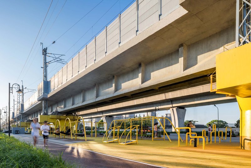
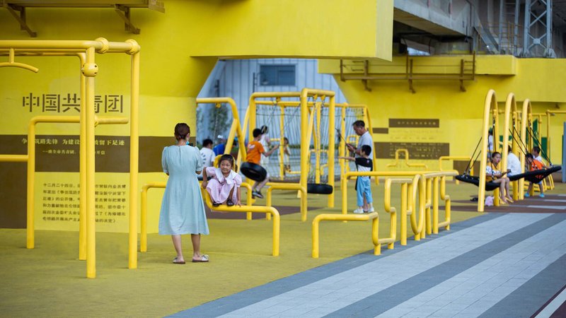
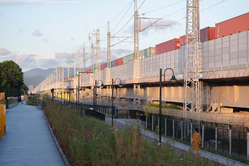
The most visually striking gesture is the occupation of the space directly beneath the active elevated railway. Bright yellow tubular playground equipment fills the undercroft of the concrete viaduct, turning a zone that would typically be fenced off or left to accumulate debris into the park's most active social node. Children climb through the frames while adults exercise on adjacent equipment. The yellow color is unapologetically synthetic against the grey infrastructure, making the intervention legible as something intentionally inserted rather than grudgingly tolerated.
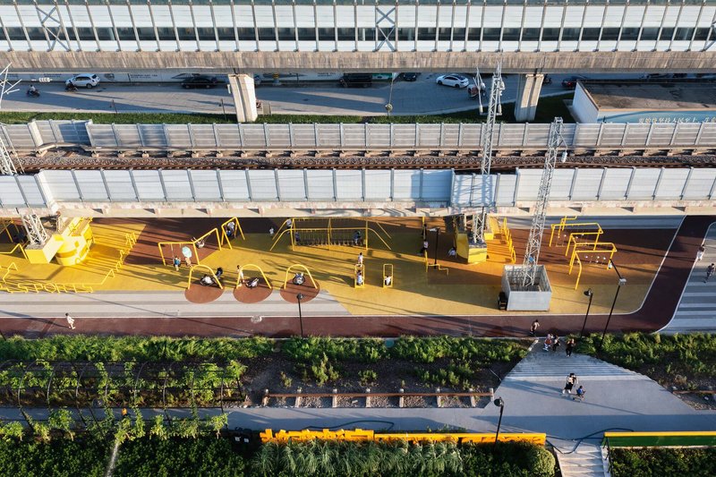
The overhead view reveals how the platform surfaces are treated as continuous ground planes in the same saturated yellow, extending the play logic across a wide swath beneath the tracks. Exercise stations line the edges. The arched canopy that runs alongside the viaduct provides a secondary datum, mediating between the massive scale of the rail infrastructure and the human-scaled activities below.
The Station as Landscape Object
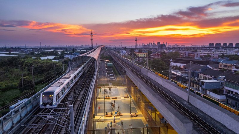
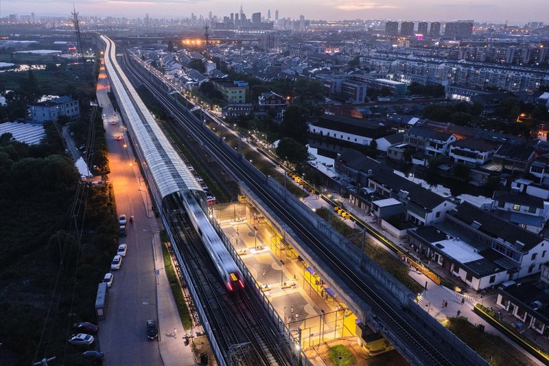
The elevated rail station is treated not as a standalone building but as a landscape element in the park's sequence. Sunken glass-walled platforms glow from within at dusk, creating a lantern effect that transforms the station into a beacon along the corridor. Tubular skylights span the parallel tracks overhead, filtering daylight down to the platform level during the day and radiating warm light outward at night.
From above, the station's curved glass canopy reads as a translucent seam stitched between the residential neighborhoods on either side. The aerial views make clear how tightly the rail corridor threads through the existing urban fabric. The station is not set apart from the village; it is embedded in it, with the park serving as the connective tissue that makes this adjacency feel intentional rather than accidental.
A Corridor of Rooms
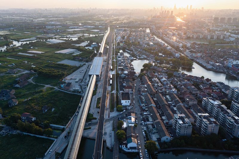
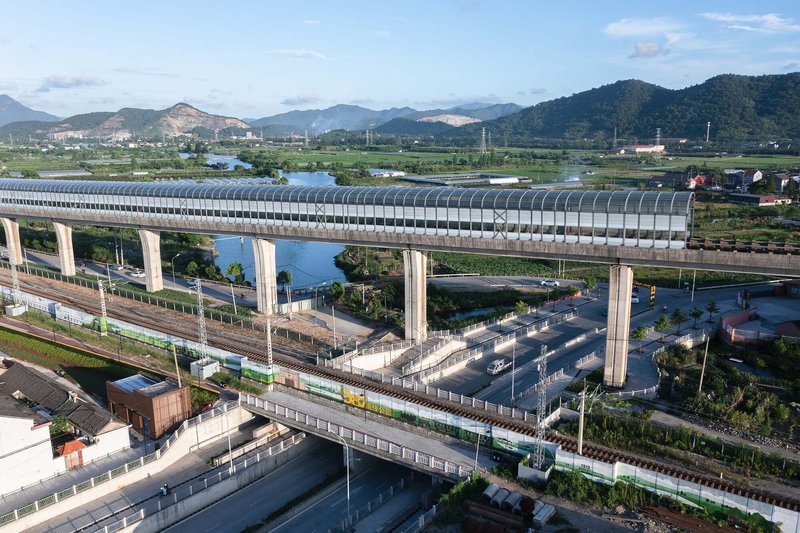
The drone photography reveals the park's fundamental organizational logic: a linear sequence of programmed spaces strung along the rail corridor like beads on a wire. Wetlands, illuminated platform canopies, yellow play areas, and arched canopy structures alternate across the 987-meter length. The park reads from above as a series of distinct episodes rather than a single continuous strip, each one responding to local conditions of width, adjacency, and grade change.
The arched tubular canopy that bridges roadways is a recurring structural motif. It provides shade, establishes vertical rhythm, and visually connects segments of the park that are interrupted by cross streets. The design team's concept of "three-line weaving, multi-dimensional connection" is most legible at this scale, where the interlocking of pedestrian paths, the abandoned rail alignment, and the active elevated line become visible as a single coordinated system.
Edge Conditions and Thresholds
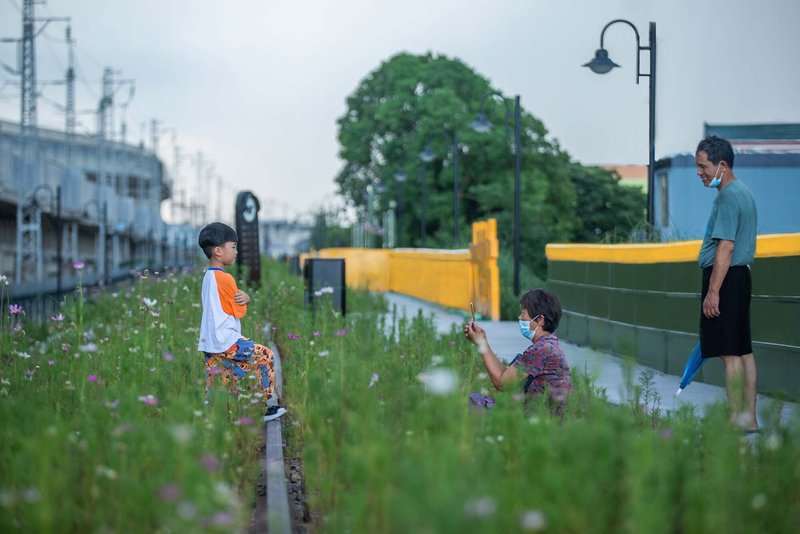
The park's edges are where the design negotiates most delicately with its context. Yellow and green barriers with horizontal slot windows create a permeable boundary between the linear walkway and the wildflower meadows that buffer the corridor from adjacent land. These staggered viewing panels frame the landscape in cinematic strips, turning a utilitarian fence into a device for controlled looking. People pause, sit, and photograph through the slots.
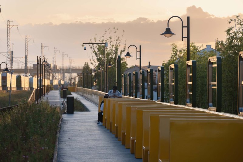
Repeating yellow benches and metal viewing frames along the railway edge establish a rhythmic sequence that gives the long promenade a sense of measured progression. The furniture is deliberately graphic: flat planes of yellow against green planting, strong silhouettes at golden hour. The effect is of a designed landscape that wears its artifice openly, never pretending to be natural but always offering a framed relationship to the natural elements around it.
Activating the Ground Plane
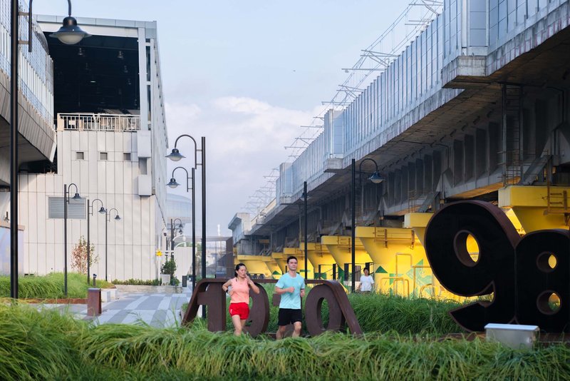
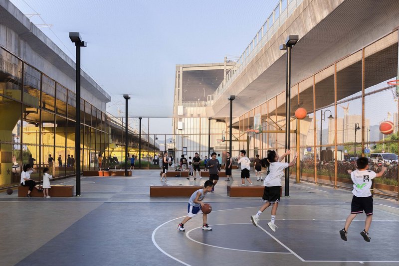
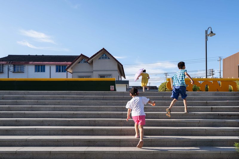
At ground level, the park delivers straightforward public amenity. Basketball courts sit between glass pavilions with an elevated pedestrian bridge floating above. Wide concrete steps become informal gathering terraces where children run and adults sit. Yellow sculptural elements punctuate the plaza spaces beneath the elevated rail, giving joggers and pedestrians visual markers along their route.
The design continues the existing village texture rather than overwriting it, threading the park's path network through the breakpoints in the road grid between lanes and site. The result is a public space that functions as both a destination and a shortcut, a place people go to and a place people move through. The distinction matters: the best linear parks are the ones that earn daily use from locals, not just weekend visits from tourists.
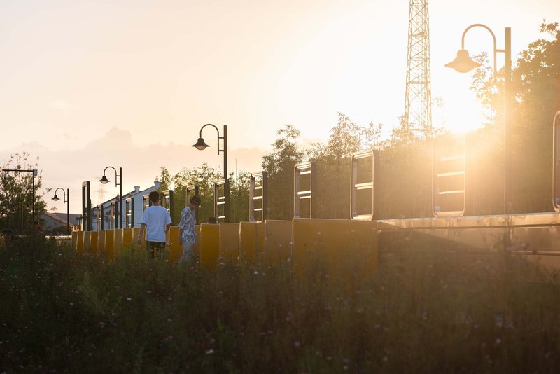
The Promenade and Its Infrastructure
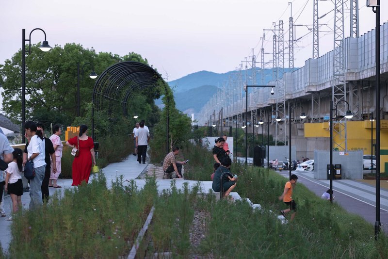
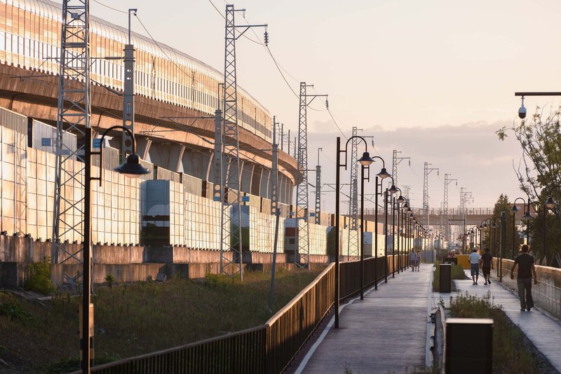
The pedestrian walkway itself is the project's spine. Planted beds line the path, arched trellises provide intermittent shade, and visitors gather at nodes along the route. The corrugated metal walls of the station buildings serve as backdrop, their industrial texture left largely unadorned. At golden hour, the walkway becomes a social promenade: people stroll, pause at benches, and lean on railings overlooking the tracks.
The elevated pedestrian walkway alongside the active railway infrastructure puts walkers in close proximity to catenary towers and overhead wires. Rather than screening this equipment, the design frames it. The infrastructure becomes scenery. The corrugated metal, the cable stays, the structural columns of the viaduct: all are visible, all are part of the experience. The park does not pretend the railway isn't there. It makes the railway the point.
Softening the Corridor
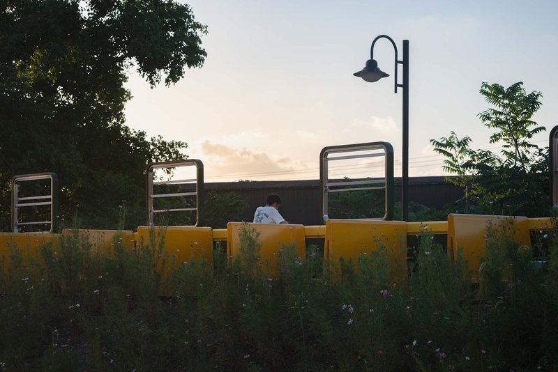
The quieter moments in the park are equally considered. A person seated on a yellow bench behind a planted buffer zone at twilight, a single street lamp overhead, exercise equipment visible in the background: this is the park at its most quotidian and perhaps its most successful. The planting strategy softens the hard edges of the infrastructure without concealing them, creating pockets of intimacy within a corridor defined by massive engineering.
Plans and Drawings
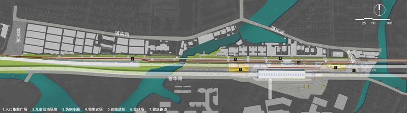
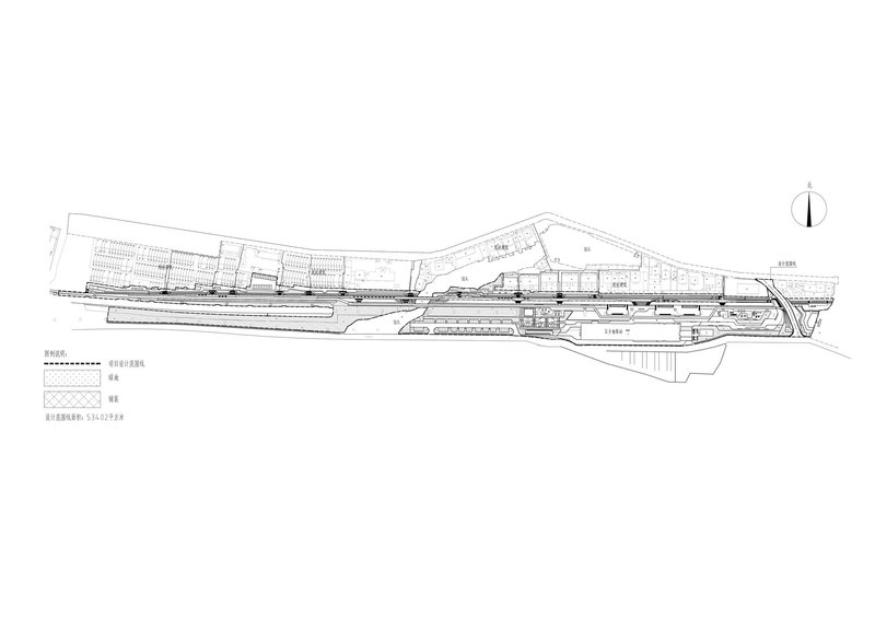
The site plan makes the park's ambition legible at a scale that the ground-level photographs cannot. The 987-meter linear pathway runs parallel to a waterway, buffered by green zones that widen and narrow according to the available land. The section drawing reveals the multi-level complexity of the site: stepped terrain with platforms and ramps connecting different grades, the park functioning as a three-dimensional connector rather than a simple surface. The 89,000-square-meter total area, split between the 53,000-square-meter red line area and 36,000 square meters of integrated old village land, shows how much territory the project actually claims.
Why This Project Matters
The comparison to New York's High Line is inevitable and, for once, partially fair. Both projects repurpose abandoned rail infrastructure as elevated or linear public parks. But the Wuxiang 987 High Line Park operates in a fundamentally different context: not a gentrifying post-industrial neighborhood in a global city but a semi-rural town on the edge of Ningbo's expanding metro network. The park is not a cultural amenity layered onto an already desirable real estate market. It is an attempt to create the connective tissue that will make a future TOD community viable, linking schools, a subway station, village centers, and river quays into a coherent public realm.
The project's real contribution is its demonstration that infrastructure redundancy is a design opportunity, not just a remediation problem. When a century-old rail branch becomes obsolete, the land it occupies retains the geometric logic of connection: linearity, grade separation, right-of-way width. Ningbo Urban Construction Design and Research Institute worked with that logic rather than against it, treating the abandoned rail as a connective axis and the active rail as a sheltering canopy. The result is a park that acknowledges its own contingency. It exists because of infrastructure, it lives within infrastructure, and it makes no apology for that condition.
Wuxiang 987 High Line Park by Ningbo Urban Construction Design and Research Institute. Ningbo, China. Approximately 89,000 square meters. Completed 2021. Photography by Wenjie Jiang, NingBo Leteam Media Co., Ltd., Zhang Jin Image Studio, and Holi Landscape Photography.
About the Studio
Share Your Own Work on uni.xyz
If projects like this are the kind of work you want to make, uni.xyz is a place to publish your own, find collaborators, and enter design competitions.


Popular Articles
Popular articles from the community
gru.a Builds a 70 m² Timber Shelter That Opens Like a Farm Door in Brazil's Valley of the Vines
In the mountainous region near Rio de Janeiro, a compact retreat uses plywood panels and deep eaves to blur the line between inside and out.
OMCM arquitectos Builds a Summer House in Paraguay from Quarry Waste Blocks and Three Sacred Trees
In the young hillside neighborhood of Altos, a 696-square-meter concrete volume hovers on six pillars around three preserved native Yvyraju trees.
Johnston Architects Reimagines the Methow Valley Hay Barn as a Small-Town Library in Winthrop
A 7,300-square-foot timber library channels the region's agrarian vernacular to serve a rural Washington community of 400 year-round residents.
BAUEN Builds Two Rammed Earth Volumes in Paraguay Inspired by the Ovenbird's Nest
In San Bernardino, a house of compacted earth channels the instinct of a constructive bird to shelter life from the Paraguayan summer.


Similar Reads
You might also enjoy these articles
127af Flips a Tiny Bagnolet Rowhouse Upside Down with a Handcrafted Roof Extension
A 55-square-meter terraced house on the edge of Paris gains a luminous upper living floor through lightweight timber and steel.
1.61 Design Workshop Wraps a 600-Square-Meter Café in Vietnam in Sculptural Burgundy Drama
Reden Café & Bistro pairs a helical staircase, mosaic floors, and deep red interiors to rethink Vietnamese hospitality space.
The Unbound Brain: A School Shaped by Cognitive Architecture
Cylindrical learning pods radiate like neurons from a central cortex, turning the floor plan into a spatial model of human thought.
Revival Vernacular Architecture: Rammed Earth Settlements for the Sahara
A modular desert community in Mauritania that fuses passive cooling techniques with earthen construction and local craftsmanship.


Comments (0)
Please login or sign up to add comments
No comments yet. Be the first to comment!