

Transitional Linkage: An Elevated Pedestrian Spine That Formalizes a City's Most Dangerous Shortcut
Zillur Rahman turns an informal crossing over rail and highway into a raised civic spine that ties six transport modes together at a single shared level.


Every city has paths that never appear on a plan: worn tracks where people decide, collectively and daily, that the official route is too long. Transitional Linkage starts from one of these. An invisible but heavily used pedestrian line cuts straight across a railway and a major highway, traced by residents and commuters who have chosen directness over safety. Rather than fencing the shortcut off, the project accepts it as the most honest piece of data on the site and builds the entire scheme around it.
Designed by Zillur Rahman, the project is a transit-oriented development set at a dense urban node where an airport corridor, a railway station, a highway, a bus stand and emerging mass rapid transit lines all converge. Rahman's mapping of the area identifies the pressure points: airport access zones, railway and MRT stations, bus and BRT stands, and the markets, schools and commercial clusters that feed them. Vehicular stand mapping shows overlapping modes competing for space around the airport, while walking path analysis exposes the continuous, unsafe desire line that becomes the project's generator.
A Forecourt That Receives the Desire Line Instead of Blocking It
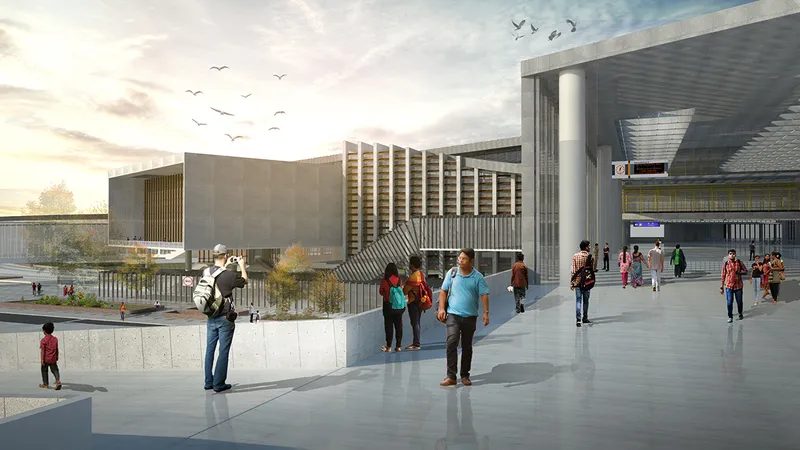
The ground-level forecourt reads as a place people are already passing through rather than a threshold they must negotiate. A single round column and louvered concrete volumes frame the approach, and the pedestrians crossing the open plaza are doing exactly what they did before the building existed: taking the direct route. The difference is that the route now has an architectural destination.
This is the project's central argument made spatial. If people already move through a space, architecture should support that movement, not obstruct it. Rahman's diagrams show the danger of interrupted pedestrian flow across fast traffic and rail lines; the forecourt is the first step in replacing those conflict points with a continuous, legible axis that carries visual continuity across the whole site.
Heavy Infrastructure Softened at the Edges
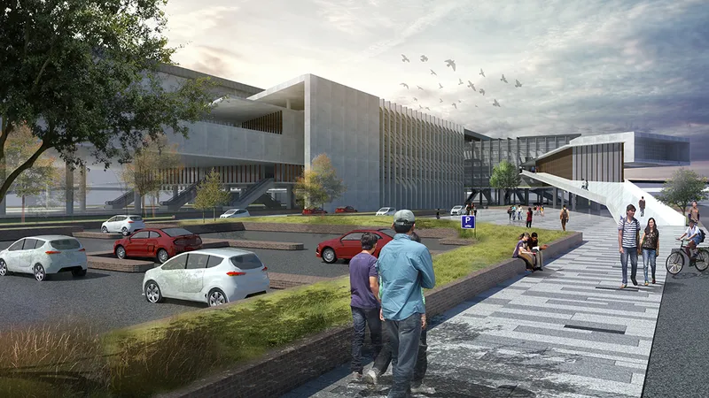
Seen from beyond the car park, the station block holds its ground as a solid concrete mass with a louvered facade, while a brick-edged planted bank mediates between the parking and the walking surface. Pedestrians and a cyclist pass along that edge, a small but telling detail: the scheme separates people from vehicular congestion without isolating the building from the street.
That separation is the real infrastructure here. The site analysis records modes jostling for space around the airport node, and the response is to sort them rather than simply enlarge them. Cars and buses get their stands; people get an uninterrupted route that sits apart from traffic, removing the conflicts that defined the existing crossing.
A Concourse That Doubles as the City's Lobby

Inside, the spine stops behaving like a bridge and starts behaving like a room. A glazed pedestrian tube runs through the concourse, cafe tables sit alongside travelers with luggage, and a grid of solar panels across the roof filters daylight onto the space below. This is the shared urban lobby Rahman describes: a level where railway access, MRT and LRT connections, bus and BRT platforms, airport routes and public waiting zones all meet.
The important move is that all six transport modes connect at this single central level, with vertical circulation cores handling the up-and-down movement to each system. Transit passengers arrive, disperse and transfer here, while non-transit users can cross the site without being drawn into ticketing logic. Two very different speeds of movement share one floor without colliding, and that coexistence is what turns a transfer hall into civic space.
Massing Drawn Directly From Overlapping Lines of Movement

The axonometric makes the form derivation legible. A long, elongated roof volume spans the crossing tracks, with angled wings branching off it and a parking lot running alongside. Rahman's form studies translate the movement diagrams almost literally: the massing grows from overlapping transit lines and pedestrian flows, so the dominant horizontal stretch follows the original desire line across the infrastructure barriers it once had to dodge.
This gives the building an unusual honesty. Its shape is not a gesture applied to a transport programme; it is the record of how people and vehicles were already trying to move. The angled wings read as the points where other routes peel off toward their platforms, which makes the drawing work as both a massing study and a wayfinding diagram.
Why This Project Matters
Transport hubs are usually planned from the network outward, with pedestrians accommodated wherever the rail and road geometry leaves room. Transitional Linkage reverses that order. By treating an informal, unsafe crossing as the primary evidence of need, Rahman lets observed behaviour set the spatial hierarchy, which is precisely what transit-oriented development claims to do and so rarely achieves in practice.
The proposal also insists that a transit node owes something to people who are not catching a train. Elevating the walk above traffic, gathering six modes onto one level and opening that level to anyone crossing the site turns a piece of infrastructure into a public route. For cities where desire lines routinely run across highways and tracks, it offers a clear model: formalize the shortcut, make it safe, and let it become the building.
View the Full Project
About the Designers
Designer: Zillur Rahman
Enter a Design Competition on uni.xyz
uni.xyz runs architecture and design competitions year-round that reward proposals with spatial conviction and real site intelligence.
Project credits: Transitional Linkage by Zillur Rahman.


Popular Articles
Popular articles from the community

Faces of the Soviet Avant-Garde: Turning Moscow's Street Names into an Open-Air Museum
A network of sculptural installations across a Moscow residential district transforms forgotten architect names into spatial encounters with cultural memor
Manzana Morphosis: Stretching Barcelona's Grid into a Living Landscape for 2050
A radical reworking of the Eixample manzana turns density into a tool for generous public space, vertical ecology, and environmental performance.
Opera on the Sea: Driftwood Logic Shapes a Timber Opera House on Estonia's Coast
Trevor Orgill's opera house translates the entangled drift of floating timber into a civic building where wood, water, and music converge.
Cloaked Colonization: A Mobile Underwater Habitat That Moves Like a Fish
Micah Abaya's shortlisted EHC Pacific entry reimagines ocean settlement as a dispersed network of self-sustaining architectural organisms.

Similar Reads
You might also enjoy these articles

Healing Façade: A Modular Chapel System That Restores Ethiopia's Sacred Forests
Winner of the Eco-Chapel competition, this circular timber façade collects water from air to rebuild soil and reforest degraded Ethiopian landscapes.
Kaffeebühnen: Where Coffee Shop Architecture Becomes a Civic Stage in Vienna
A linear sequence of timber boxes, transparent shells, and open yards turns the Viennese café tradition into a public performance space.
Eco Chapel: A Modular Forest Pavilion That Grows Like the Landscape It Protects
Hexagonal timber modules weave through existing trees, turning a chapel into a living system for prayer, education, and reforestation.


Urban Forest: A Vertical Ecosystem for 5,000 Workers in Singapore's Changi Business Park
Radially stacked pods and layered green decks turn a 7-acre plot into 47 acres of ecological workspace projected for 2040.

Explore Urban Mobility Competitions
Discover active competitions in this discipline

Challenge to reimagine the Iron Throne

Photograph architecture without architects

Illustrate the lost glory of Angkor Wat - Render Challenge

Design challenge to reuse E-waste
Comments (0)
Please login or sign up to add comments
No comments yet. Be the first to comment!