

Tribeca Drone Nest Cityscraper: An Inverted Manhattan Tower That Funds Housing From the Sky
A shortlisted CityScraper 2020 tower that widens as it rises, stacking commerce and a drone port beneath subsidised homes for New York's key workers.


Manhattan has spent a century sharpening its towers into points, and every point has been sold to the highest bidder. The Tribeca Drone Nest Cityscraper turns that logic upside down. The tower swells outward as it climbs, and the widest, brightest floors at the top go to subsidised housing for key workers and ordinary New Yorkers. They do not go to penthouses or executive suites. Commercial floors, restaurants, markets and a passenger drone port do the earning below, and their revenue pays for the community above.
Designed by Alun Moreton, the proposal was shortlisted in CityScraper 2020. It occupies 33 Thomas Street, the site of the AT&T Long Lines Building near City Hall. That windowless, monumental block sits between Tribeca, the Civic Center and the Financial District. The choice of site is pointed. Moreton plants a dense, mixed-use vertical neighbourhood on one of Lower Manhattan's most infrastructural addresses, which shows what a skyscraper could be if it behaved like civic infrastructure and stopped acting as a speculative asset.
A Silhouette That Widens Where Others Narrow

In the skyline view, a twisting glass tower punctured by hexagonal openings rises above the surrounding blocks, with small yellow drones circling its flanks. The defining move is in its profile. Moreton describes the form as inverted and "yonic," a deliberate counterpoint to the tapered, phallic silhouette that dominates the city. The upper residential volume spreads outward, so the building holds more floor area at the top than a conventional tower would.
Here, form and politics are the same gesture. A tapering tower rations its scarce top floors, and that scarcity drives their price. By expanding the crown, the project produces more of the most valuable space in the building: light, long views and height. It then assigns that space to subsidised apartments, gardens and shared facilities. The silhouette becomes a redistribution diagram you can read from across the river.
Commerce, Flight and Home Stacked in One Section
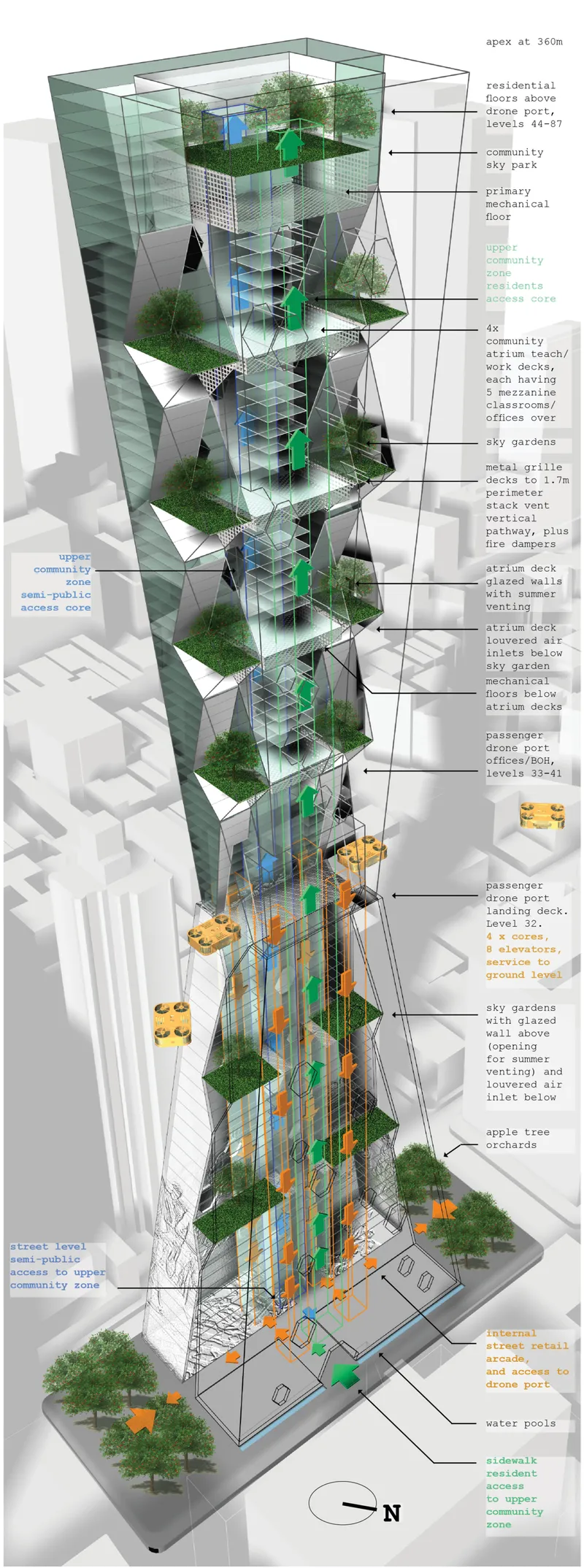
The exploded axonometric shows the logic plainly: stacked sky gardens, atrium decks, drone port levels and an orchard at street level, all held within one continuous structure. The numbers are substantial. The tower is roughly 360 metres tall, with about 178,420 square metres of gross floor area across 32 commercial floors, 12 drone port floors and 43 floors of residential and community programme.
Many mixed-use towers split their functions into isolated strata that barely acknowledge each other. This one makes the stacking order carry its economic model. Revenue-generating commercial space and aerial mobility infrastructure sit in the lower and middle levels, and they underwrite the housing, education and community spaces overhead. The drone port does real work in that arrangement. It acts as a hinge between the paying city and the subsidised one, and it bets on an emerging transport network to keep the whole system solvent.
A Carved, Planted Base for Thomas Street
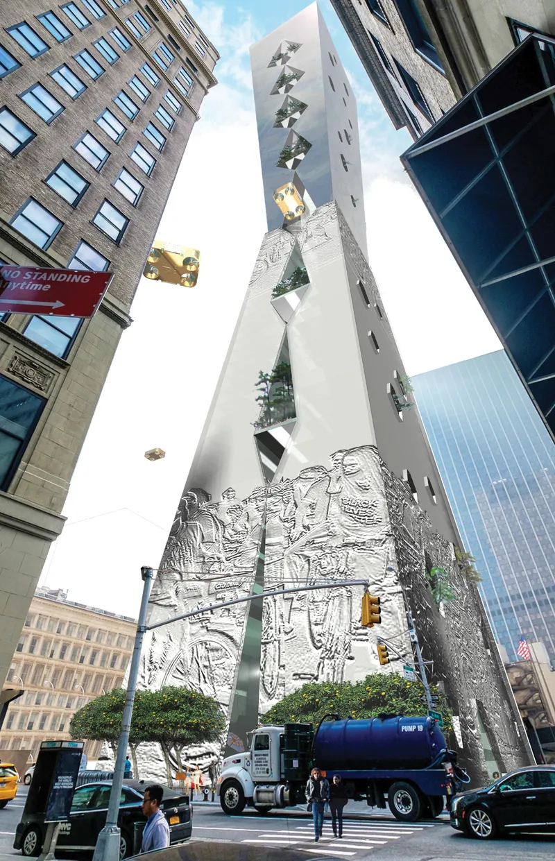
At street level, the low-angle view shows a base with a relief-carved facade and planted notches cut into its surface, while a water truck crosses in the foreground. On a site known for blank, sealed elevations, this matters. The ground floor is textured and green, and it signals that the building expects people to stop here, not just pass by.
Moreton's brief for the base is about time as much as space. This part of Lower Manhattan can empty out after business hours. Schools, workshops, gardens, restaurants and public market spaces would bring residents and visitors through the site well into the evening. The tower becomes a catalyst for a more socially mixed district, and it no longer reads as an office monolith that switches off at six.
Trees and Drone Pods in the Upper Volume
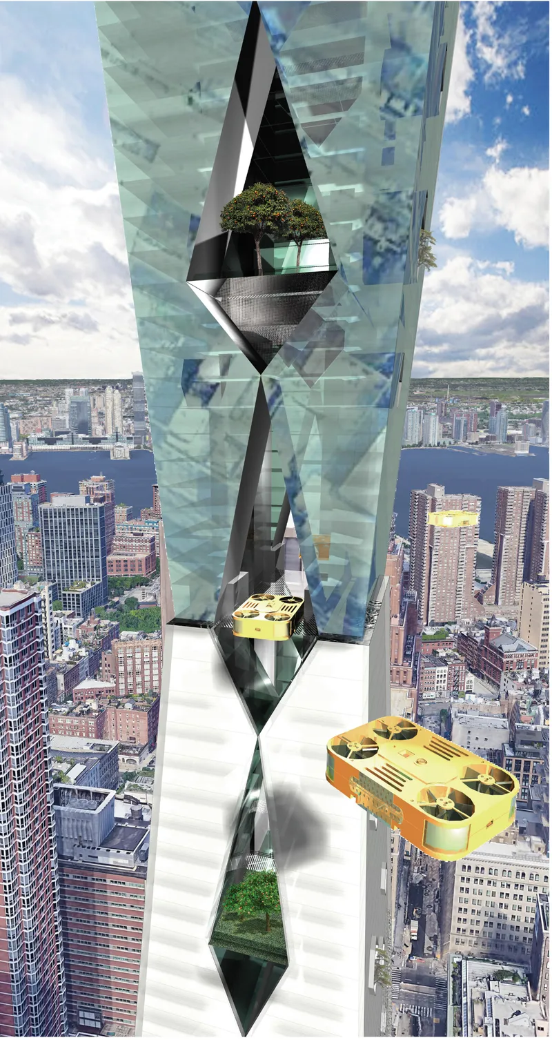
The close-up of the upper tower may be the most persuasive image in the set. Diamond-shaped openings in the glass skin hold full trees, and drone pods hover beside the facade above the river and the city grid. The openings work as hollowed-out outdoor rooms that pull gardens into the residential floors, and they give the passive environmental strategy a visible, inhabitable form.
This imagery also clarifies who the crown belongs to. The planted voids and the views they frame would normally be marketed as luxury amenities. Here they become the everyday surroundings of key workers' homes. The drones parked alongside make the point that this community connects to the city's newest mobility network, so it does not have to rely on whatever infrastructure is left over.
Why This Project Matters
Speculative skyscraper competitions often reward novel shapes. The Tribeca Drone Nest stands out because its shape is an argument. Inverting the tower is a formal gesture, but it also asks who gets the top of the city and why. Pairing that inversion with a self-financing model gives the provocation real substance: the commercial and drone floors pay for affordable housing within the same structure.
The drone economy remains uncertain, and a 360-metre cross-subsidised tower would face serious tests in practice. The underlying proposition still holds. Density, mobility and housing can be designed as one interdependent system, and the most coveted spaces in a building can be allocated by civic priority instead of price. For a city whose skyline has become a ledger of private wealth, Moreton offers a striking alternative, one that widens as it rises.
View the Full Project
About the Designers
Designer: Alun Moreton
Enter a Design Competition on uni.xyz
uni.xyz runs architecture and design competitions year-round that reward proposals with spatial conviction and real site intelligence.
Project credits: Tribeca Drone Nest Cityscraper by Alun Moreton CityScraper 2020 (uni.xyz).


Popular Articles
Popular articles from the community

Manzana Morphosis: Stretching Barcelona's Grid into a Living Landscape for 2050
A radical reworking of the Eixample manzana turns density into a tool for generous public space, vertical ecology, and environmental performance.


graciastudio Turns a Viewless Tijuana Lot Inward Around a Courtyard of Concrete, Timber and Trees
In Tijuana, Jorge Gracia's GA2 House stacks a timber-clad private floor over exposed concrete and replaces a missing view with a planted interior patio.

Cube Design Draws an Ecological Corridor Between Two Shenzhen Hills with the Nankai Building
Beside Shenzhen's container docks, the Nankai Building pairs stacked balconies with a climbing green screen to connect two hillsides across its height.

David Ortega Stacks a Two-Story Mexico City Penthouse Around a Steel Stair and a Pergola-Shaded Roof Terrace
In Colonia Roma, a 300 m² penthouse uses oak joinery, a planted steel stair and a slatted roof pergola to make a new-build apartment feel like a house.

Similar Reads
You might also enjoy these articles
Healing Façade: A Modular Chapel System That Restores Ethiopia's Sacred Forests
Winner of the Eco-Chapel competition, this circular timber façade collects water from air to rebuild soil and reforest degraded Ethiopian landscapes.
Kaffeebühnen: Where Coffee Shop Architecture Becomes a Civic Stage in Vienna
A linear sequence of timber boxes, transparent shells, and open yards turns the Viennese café tradition into a public performance space.
Eco Chapel: A Modular Forest Pavilion That Grows Like the Landscape It Protects
Hexagonal timber modules weave through existing trees, turning a chapel into a living system for prayer, education, and reforestation.


Urban Forest: A Vertical Ecosystem for 5,000 Workers in Singapore's Changi Business Park
Radially stacked pods and layered green decks turn a 7-acre plot into 47 acres of ecological workspace projected for 2040.

Comments (0)
Please login or sign up to add comments
No comments yet. Be the first to comment!