
Embankment Settlement: An approach towards a Strategic Community Settlement.
Developing The Embankment As a new Housing Infrastructure.
Bangladesh is the largest delta in the world, formed by the Ganges, the Brahmaputra and the Meghna (GBM) river system. Because of Bangladesh’s flat topography, low-lying and climatic features make it highly susceptible to many natural hazards. Disasters like cyclones and flood cause enormous effect of people and property in Bangladesh. Charfassion, upazilla of Bhola which is situated in the coastal belt of Bangladesh has experienced disasters like river erosion, cyclones and flood every year. So, Construction of embankments is an established and inseparable practice here for protecting people’s lives and homes, agriculture and infrastructures. The poverty stricken landless people find this embankment as the safest place for their living and so these embankments are becoming the part of these rural settlement. This paper focuses on to develop the embankments as the social infrastructure and developing an unique vernacular architecture in Bangladesh by improving the traditional embankment settlement.
Introduction
Bangladesh has a total of 2.85 million hectares of coastal and offshore land areas (711 km long), that consist of a large network of river system. coastal region of Bangladesh is highly susceptible to tropical cyclones, river erosion and flood due to its geographical location. More than 80 percent of the population is potentially exposed to floods, earthquakes and droughts, and more than 70 percent to cyclones.
flood and riverbank shifting have played a major role in shaping the physical, biotic and demographic landscape of Bangladesh for a very long time. Because of the endemic and widespread nature of flood and riverbank shifting in the region, people all across what is now Bangladesh have a long history of adaptation to flood. In some areas, the destruction of land due to riverbank erosion has been a critical part of daily experience for centuries. For protecting the land from river erosion, flooding and tropical surges designing the embankment has been the common practice from ancient time. During the last few decades, under the programme of flood control and drainage improvement, about 16261 km of embankment, among them coastal embankments are 5700 km, Flood controlling structure 7900 km and drainage channel are 4310 km have been established.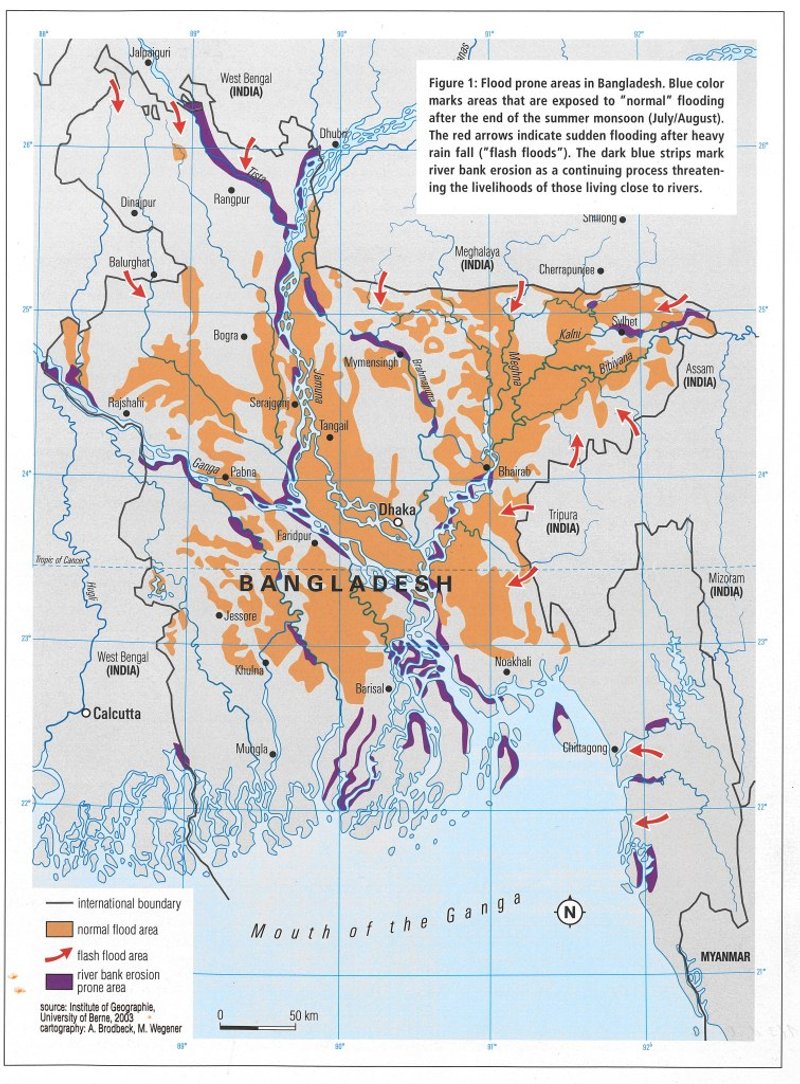
Flood Map Of Bangladesh
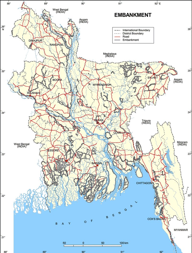
Embankment Map
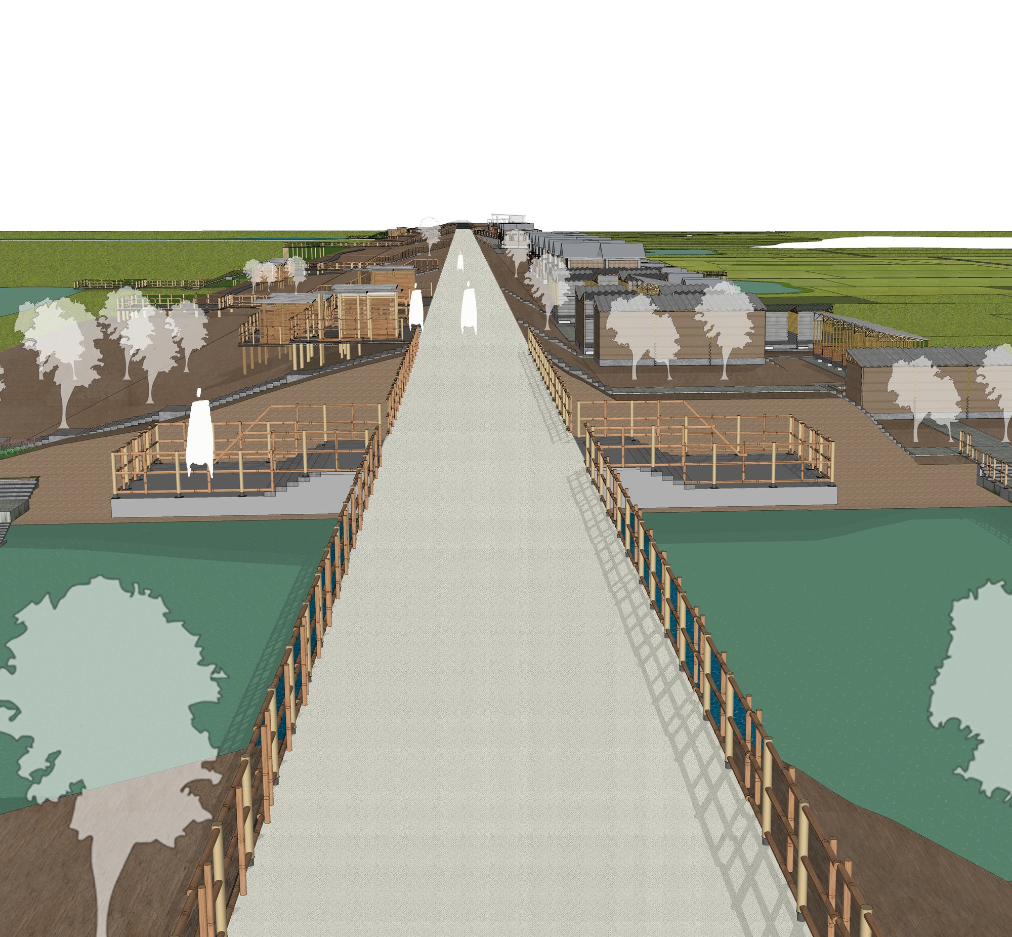
In Bangladesh, about 25 percent of the land mass is inundated with flood every year and about nearly 12 million people live in poverty in the coastal region of Bangladesh. Roughly a million people a year are believed to shift residence, because of their homes and land are washed away or to take advantage of newly accreted land and also being affected by physical phenomena, riverbank erosion and flood. In coastal regions, uprooting people and landless people find their new homes in those embankments. They established their settlement on nearby embankment and set a form of vernacular architecture. This study focuses on the improvement of the embankment settlement in Coastal area and thus establishing a improved community settlement.
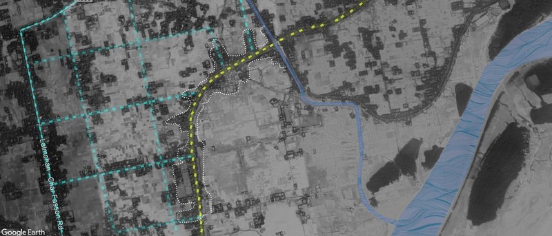
Site Location
The context of the study is Charfasson upazila which situated in Bhola zila, the largest riverine delta island of the world. It is bounded by Lalmohan Upazila on the north, Bay of Bengal on the south, Manpura upazila, Shahbazpur Channel and Bay on the east, Dashmina and Galachipa Upazilas on the west. Charfassion of Bhola district is one of the erosion prone districts of the Bangladesh.
Site :Charfasson, Bhola
Site Area:24 acre (Approx)
Charfassson, Bhola south central coastal area of Bangladesh has been selected as the project site.Bhola is the largest delta island of Bangladesh with an area of 3737.21 km2. Charfasson, one of the upazilla of Bhola surrounded by Lalmohan Upazila on the north, Bay of Bengal on the south, Manpura upazila, Shahbazpur Channel and Bay on the east, Dashmina and Galachipa Upazilas on the west. It is one of the erosion prone area of Bangladesh with an embankment of 100 km.The Embankment area of the Charfasson are the main Design area. About the 20,000 landless people are living in those embankments.
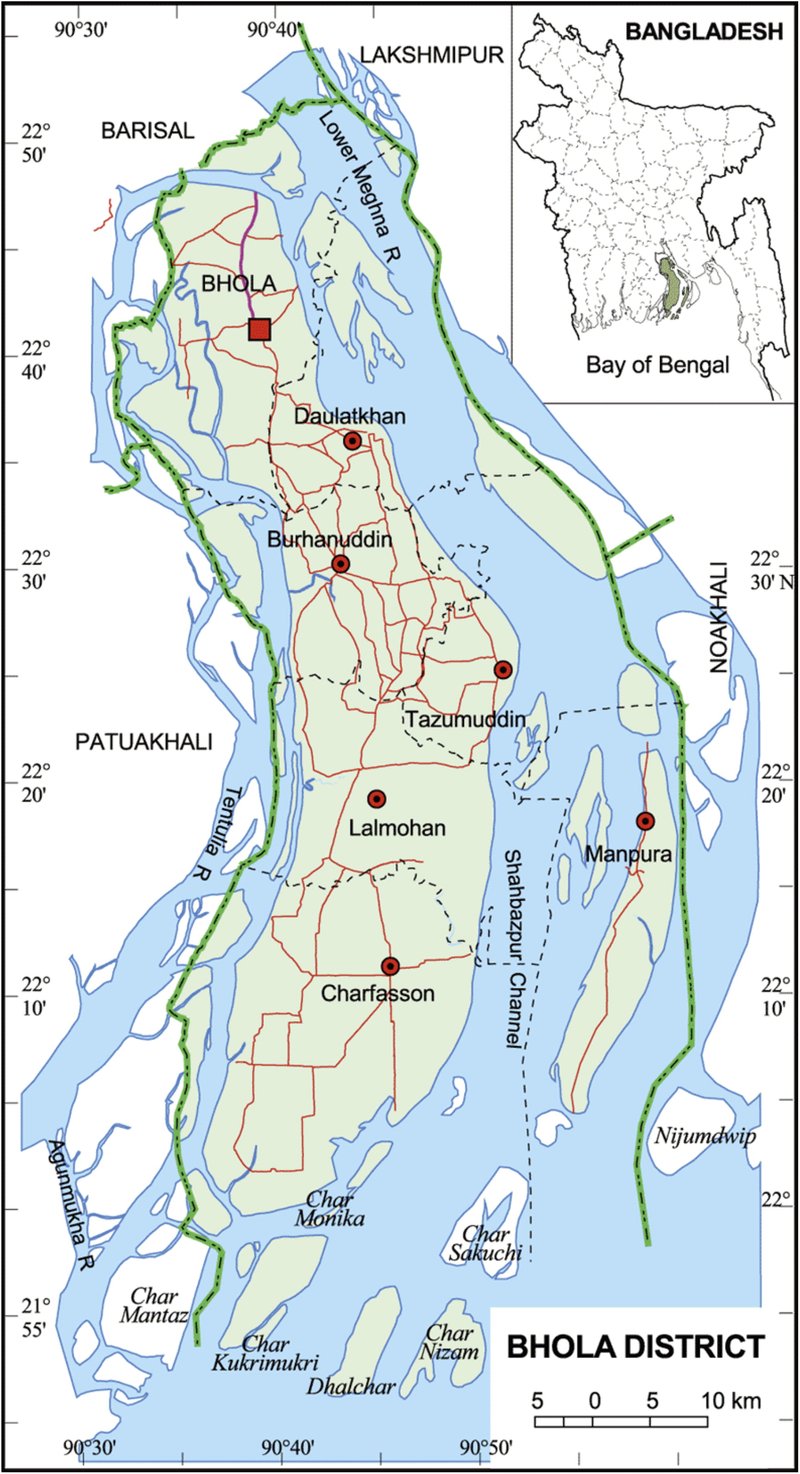
Bhola Map
Location
Needs of Study
Coastal region of Bangladesh, the most low-lying part of the country, is the homeland of 50 million people, nearly one-third of huge population of densely populated Bangladesh (Marziya 2010-11). Charfassion,Bhola being the south central coastal region of Bangladesh is exposed to flood, river erosion and saline intrusion. About 100 km embankments are situated in Charfassion and this embankment become the place of 20,000 landless families. This embankment has become the rural slum and the safest place for living for those uprooted people.
Since the late 1970s, other displaced people have decided to settle on the embankments. This study is needed because it will enable us to know about the current embankment condition and the situation of the landless people there. We can create a new kind of embankment infrastructure with the housing provision which will enable the embankment people to live there and earn their livelihood as well. It also enables us to know about the vernacular settlement pattern of these embankment people and give a scope to enhance their livelihood facilities.
Aim
The aim of the project is to establish the embankment as the main social infrastructure and create a new vernacular architecture in Bangladesh by improving the traditional embankment settlement as these Settlements are an unavoidable feature where erosion affects and thus giving them a better livelihood by creating communal facilities and improving their economic condition.
Objectives
Establishing the embankment as the social infrastructure and improving its current condition.
Improving the Traditional housing of embankment.
Developing the economic activities of the embankment people by creating facilities to earn their livelihood.
Developing the community facilities of the embankment people.
Creating sustainable housing technique for the settlement and promote using local materials and techniques.
Promoting Food security, social protection and sanitation.
Promoting Comprehensive disaster management.
Creating climate resilient coastal Fisheries and livestock
Creating Climate Resilient Coastal Agriculture.
Developing Resilient Coastal Afforestation and Reforestation program.

Popular Articles
Popular articles from the community
Atelier Macri Concept Store Interior Design by CASE-REAL
Atelier Macri store features a "ko" counter, walnut wood details, cork displays, blending retail, gallery, and seamless customer experiences.
On the Brooks House by Monsoon Collective – A Contemporary Kerala Home Rooted in Tradition
Kerala home blending tradition and modernity with water-inspired design, brick architecture, courtyard planning, and sustainable rainwater harvesting strategies.
A Contemporary Take on Iranian Residential Architecture
A modern interior design in Mashhad that reinterprets brick, light, and spatial flow to create a warm, contemporary residential architecture.

Treehouse Apartment: A Warm Timber Interior Blending Craft, Play, and Contemporary Living
Warm timber apartment with integrated treehouse, combining natural materials, craftsmanship, and playful design to create a flexible, family-oriented living environment.


Similar Reads
You might also enjoy these articles
Converge Hub – A Human-Centered and Sustainable Mobility Hub at the Urban Edge
Its open and permeable design promotes sustainable movement through walkable connections, green axes, and integrated public transport
51st Annual KRob - Ken Roberts Memorial Delineation Competition
Join us in celebrating 51 years in excellence in architectural representation! With $2,400 in prize money awarded across 8 categories, this prompt-less competition is accessible to all!


Comments (0)
Please login or sign up to add comments
No comments yet. Be the first to comment!