

PictuRESQ: Flood-Resilient Courtyard Housing Rooted in Kerala's Building Traditions
A neighborhood-scale proposal reimagines the nalukettu courtyard typology to protect Kerala's flood-prone communities while preserving cultural identity.


When floodwaters recede in Kerala, they leave behind more than silt and structural damage. They erode the social fabric of neighborhoods, scatter families into temporary shelters, and force communities to rebuild without a coherent plan. PictuRESQ refuses to treat architecture as an afterthought in disaster response. Instead, it proposes a full neighborhood block for a 30-hectare site in Uliyannoor, near the Aluva River backwaters, where recurrent flooding has displaced residential clusters and strained local infrastructure. The core provocation is deceptively simple: what if resilience were designed into the community from the ground up, rather than bolted on after the next disaster?
Developed by GruhaSree Deevi, Ishita Saraswat, Siddhesh Kudale, and Karthik Girish, the project takes its name from "picturesque" and "rescue," signaling a dual commitment to cultural beauty and practical protection. The design philosophy draws on what the team calls the sandcastle concept, built around three pillars: location near water with guaranteed stability, buildability through simple construction that communities can execute themselves, and sustainability through locally abundant materials and traditional knowledge. Published on uni.xyz, PictuRESQ positions itself not as a utopian masterplan but as an adaptable framework that other flood-prone regions could learn from.
Reading the Land Before Drawing on It
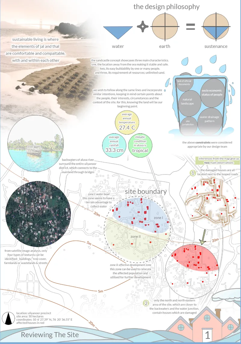
The site analysis is meticulous and honest about constraints. Satellite mapping and topographic surveys of the Uliyannoor precinct reveal three distinct zones: a water bowl area with natural collection potential (Zone I), an effective development zone suitable for resettlement (Zone II), and existing flood-affected residential clusters that need relocation (Zone III). Climate data, vegetation patterns, and drainage flows are layered together to determine where building is viable and where water should be allowed to do what it does naturally. The diagram communicates a principle that many masterplans skip over: the land's hydrology sets the rules, and architecture must comply.
This zoning becomes the project's organizational backbone. Rather than spreading development uniformly across 30 hectares, the team concentrates housing and community infrastructure in Zone II while dedicating Zone I to retention ponds, agricultural fields, and green infrastructure that double as flood buffers. Zone III residents are relocated into the new courtyard housing clusters, a decision grounded in risk reduction rather than aesthetic preference.
A Circular Masterplan Organized Around Access and Evacuation
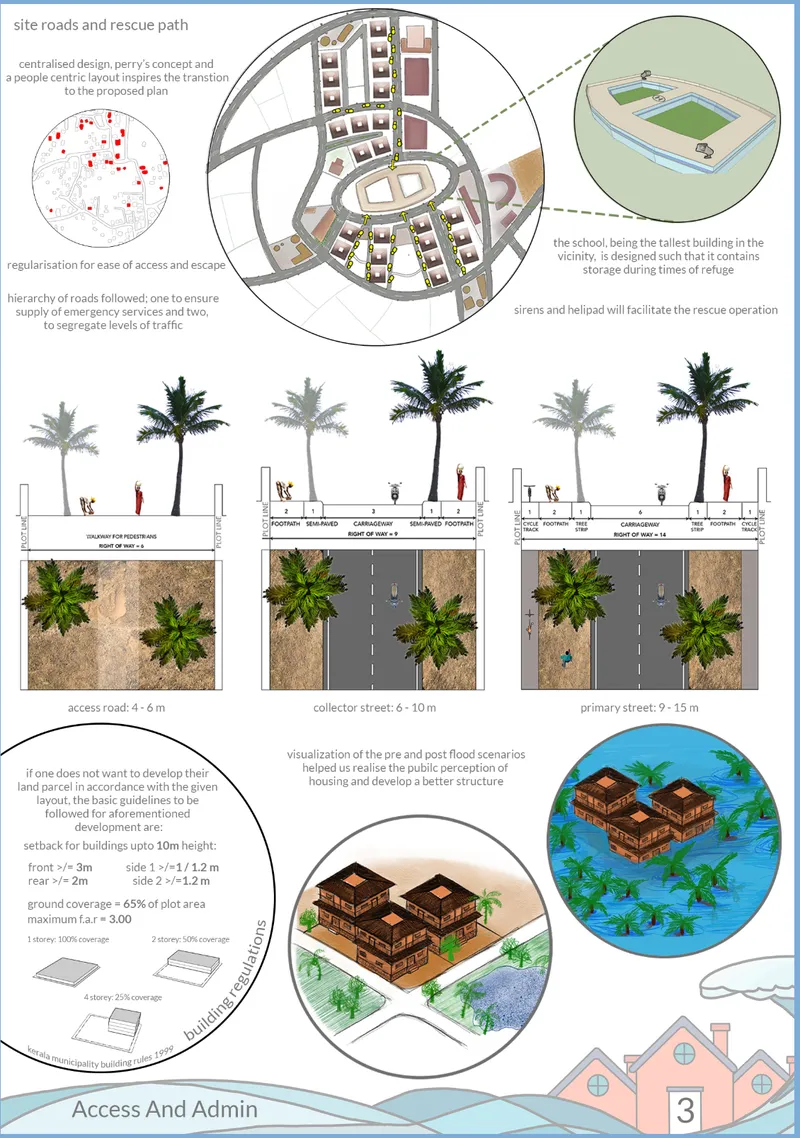
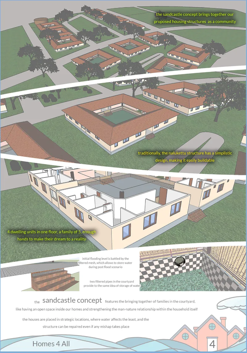
The site plan reveals a circular layout that integrates residential, institutional, and public functions around a hierarchical road network. Access roads, collector roads, and primary roads are designed not just for daily movement but for emergency evacuation, complete with siren systems and helipad provisions. Palm-lined sections and isometric cluster views show how the road hierarchy weaves between courtyard housing blocks, connecting them to a community core that includes a school, mosque, auditorium, and government offices. The aerial axonometric views make the terracotta-roofed clusters legible at neighborhood scale: tight groupings of nalukettu-inspired homes with shared courtyards, oriented to manage airflow and surface water.
What distinguishes this masterplan from generic resettlement schemes is its insistence on cultural anchoring. The community core is deliberately placed at the center, ensuring that education and shared civic life, not just housing units, define the neighborhood's identity. Agricultural fields, cultivation forests, and retention ponds ring the settlement, performing the dual role of food security and stormwater management. Sewage treatment plants and water pumping stations are integrated from the outset, a detail that signals the designers are thinking about long-term viability rather than just an attractive rendering.
The Nalukettu Reimagined: Courtyard Living as Collective Defense
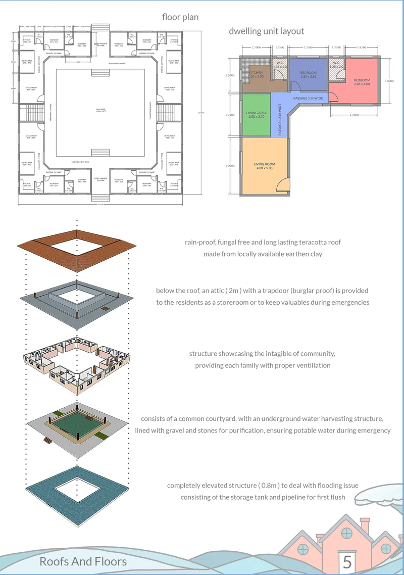
The floor plans and exploded axonometric diagrams reveal the project's most compelling architectural move: the nalukettu courtyard typology, reimagined as a flood-resilient multi-family dwelling. Each block accommodates multiple families around a shared central courtyard, reducing construction costs while preserving the spatial culture that defines Kerala's domestic architecture. Elevated platforms protect ground floors from inundation and fungal growth. Terracotta roofs, shown in layered assembly, provide thermal mass suited to Kerala's humid climate while referencing the region's vernacular material palette.
The courtyard is the social engine of the design. It brings families into daily contact, reinforcing the kind of neighborly awareness that becomes critical during flood events when information and mutual aid travel faster through tight-knit communities than through official channels. By clustering units rather than isolating them, PictuRESQ turns density into a resilience strategy. Underground water harvesting structures beneath the clusters capture rainwater and redirect excess flow toward the backwaters through a network of pumping systems, transforming each housing block into an active participant in the site's hydrology.
Bottom-Up Process: Stakeholders Before Form
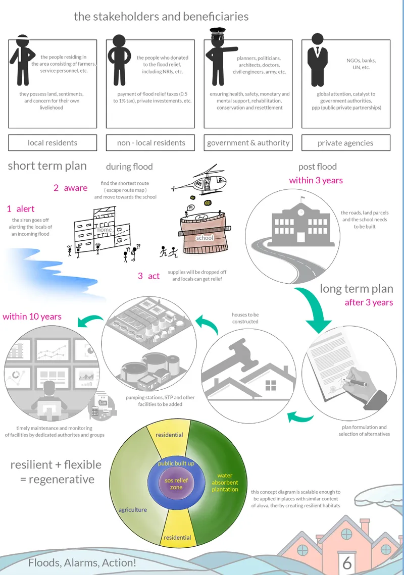
The stakeholder process diagram and flood response timeline reveal an often-neglected dimension of resilient design: who decides what gets built, and when action is taken. The team maps out a participatory framework that places residents, local government, and agricultural stakeholders at the center of decision-making. A land use distribution chart breaks down the allocation between housing, agriculture, green infrastructure, and institutional functions, demonstrating that every square meter of the 30-hectare site has been accounted for with a clear programmatic rationale.
The flood response timeline is particularly instructive. It sequences preparedness measures, evacuation protocols, and post-flood recovery into a coherent operational plan that the built environment is designed to support. Sirens, helipads, and road hierarchies are not afterthoughts; they are spatially embedded in the masterplan. The integration of rubber, banana, tapioca, and paddy cultivation into the site design further reinforces the bottom-up ethos: food resilience is not a separate policy goal but a landscape strategy that shapes the plan from the periphery inward.
Why This Project Matters
PictuRESQ matters because it treats flood resilience as a design problem with cultural, social, and ecological dimensions, not merely a structural engineering challenge. The nalukettu courtyard is not deployed as nostalgic set dressing; it is reactivated as a spatial strategy for shared defense, thermal performance, and community cohesion. The site zoning respects hydrology before asserting geometry. The road network serves evacuation before it serves traffic flow. These are disciplined design priorities, and they produce a proposal that reads as genuinely site-specific rather than generically "sustainable."
The project's most valuable contribution may be its framing as an adaptable framework rather than a finished solution. Kerala is not the only region facing recurrent flooding exacerbated by climate change, and the methodology here, layering site hydrology, vernacular typology, community participation, and emergency infrastructure, is transferable. For student work, the level of systemic thinking is impressive. PictuRESQ demonstrates that young designers can engage the hardest problems in architecture: not how to make buildings look resilient, but how to make communities actually survive.
View the Full Project
About the Designers
Designers: GruhaSree Deevi, Ishita Saraswat, Siddhesh Kudale, Karthik Girish
Enter a Design Competition on uni.xyz
uni.xyz runs architecture and design competitions year-round that reward proposals with spatial conviction and real site intelligence.
Project credits: pictuRESQ by GruhaSree Deevi, Ishita Saraswat, Siddhesh Kudale, Karthik Girish.


Popular Articles
Popular articles from the community

Opera on the Sea: Driftwood Logic Shapes a Timber Opera House on Estonia's Coast
Trevor Orgill's opera house translates the entangled drift of floating timber into a civic building where wood, water, and music converge.
The Amber Palace Opera: A Geological Fiction Surfaces on Tallinn's Baltic Waterfront
Pierre Brillard reimagines a Baltic legend as a public landscape, opera house, and waterfront promenade rooted in Tallinn's coastal identity.

Tsunami Convergenics: Turning Catastrophic Ocean Forces into Underwater Housing Infrastructure
A speculative underwater settlement off the coast of Onagawa, Japan, treats tsunamis and typhoons as energy sources rather than threats.
Opera by the Sea Estonia: Three Shells Dissolving Architecture into Tallinn's Coastline
A winning opera house proposal replaces monumental form with interconnected shells that blur the boundary between building, park and Baltic Sea.

Similar Reads
You might also enjoy these articles

Play: Fragments of Their World: Remembered Architecture Rebuilt as a Modular Playground for Refugee Camps
Tom Gardner abstracts domes, arches and towers from the homelands of displaced families into a kit of child-scaled play parts for camp settlements.
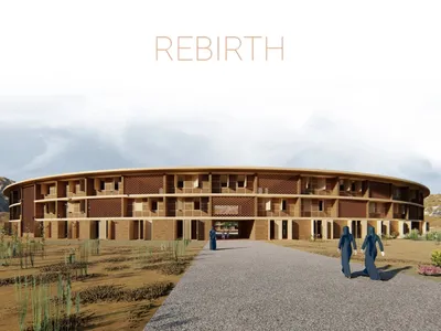
REBIRTH: A Circular Settlement Where Afghan Widows and Their Children Rebuild Life Together
A shortlisted Resile entry turns the circle into a protective ring of timber and brick, gathering homes, classrooms and gardens around a shared landscape.
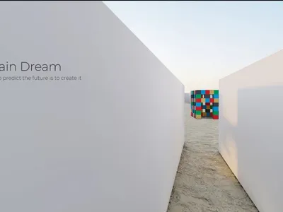
The Main Dream: A Recycled Plastic Kit That Lets Refugee Children Build Their Own Playground
Thirty-centimetre interlocking cubes that connect on three axes turn play into construction, letting children author the spaces they occupy.

Lunar Spiral: A Fibonacci-Driven Moon Settlement Rising from Shackleton Crater
Golden-spiral geometry organises buried infrastructure and orbiting habitable spheres into a lunar base designed to grow as life on the Moon expands.

Explore Kerala Floods Competitions
Discover active competitions in this discipline

Challenge to reimagine the Iron Throne

Photograph architecture without architects

Illustrate the lost glory of Angkor Wat - Render Challenge

Design challenge to reuse E-waste
Comments (0)
Please login or sign up to add comments
No comments yet. Be the first to comment!