
Directing the Flood: Designing a Neighborhood That Channels Water Instead of Fighting It
Ekaterina Popova's flood-resilient urban plan uses sunken streets and landscape reservoirs to let water move through the city on its own terms.
What if urban design stopped treating floodwater as the enemy and started treating it as a collaborator? "Directing the Flood" does exactly that, proposing a neighborhood where the main street sits lower than the surrounding ground plane, letting excess water drain away from homes and into a landscape park that doubles as a natural reservoir. The logic is counterintuitive and precisely correct: instead of raising every surface to keep water out, the design carves deliberate low points that guide monsoon runoff along a predictable, managed path.
Designed by Ekaterina Popova, the project addresses one of the most persistent challenges facing flood-prone cities: how to build livable neighborhoods in areas subject to seasonal inundation and the increasing unpredictability of climate change. The scheme spans neighborhood-scale urban planning, landscape infrastructure, and residential architecture, offering a coordinated system rather than isolated technical fixes. The full project is available on uni.xyz.
A Sunken Street as Drainage Spine
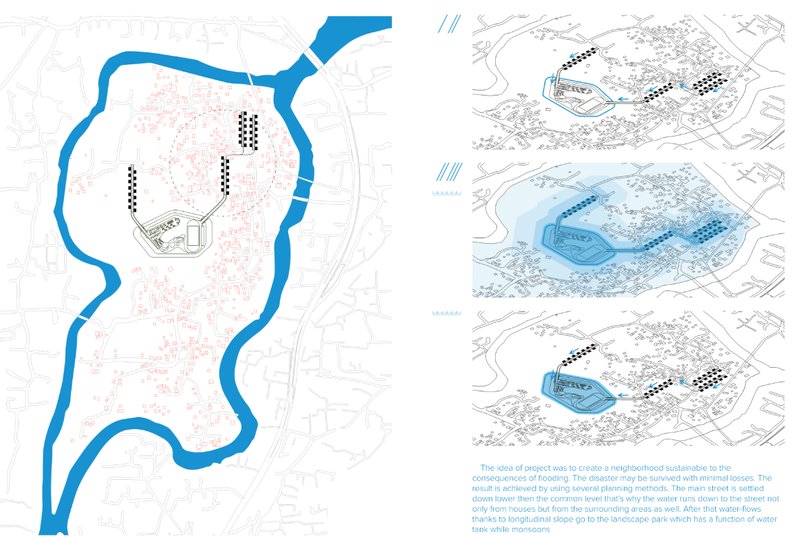
The site plan reveals the project's core move: the main street is deliberately set at a level lower than the common ground of the residential blocks flanking it. This isn't a design compromise but a calculated strategy. Water flows downhill from houses and public areas into the street corridor, which acts as a linear channel during heavy rainfall. The axonometric diagrams adjacent to the plan walk through progressive flooding scenarios, showing how the neighborhood responds as water levels rise from mild to extreme. The site's natural longitudinal slope does most of the work, directing collected water toward the landscape park at the neighborhood's edge.
Landscape Park: Recreation and Reservoir in One
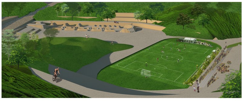
In dry conditions, the landscape park reads as a generous public amenity: sports fields, gathering pavilions, curved cycling paths, and open green space. The aerial rendering captures a relaxed civic scene, with a cyclist tracing the path around a playing field and clusters of people under a shaded pavilion. Nothing about the space screams "flood infrastructure."
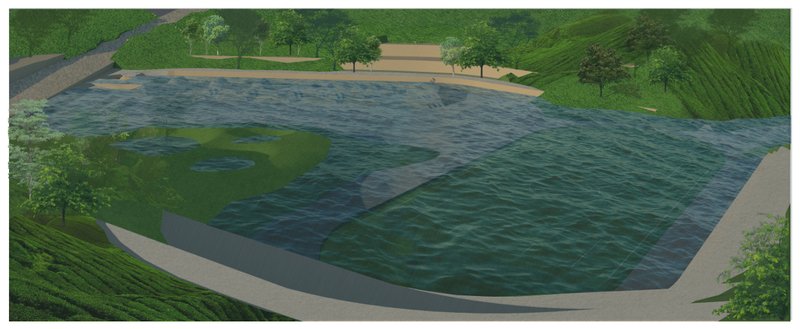
Then the second rendering shows the same view during monsoon conditions, and the transformation is striking. Water covers the playing fields and paths, and the park reveals its second identity as a natural retention basin. The design exploits the area's topographic low point to collect and hold rainwater, buffering the residential zones from the worst of the flooding. It is a dual-use strategy that treats landscape not as decoration but as critical infrastructure, enriching the urban ecosystem while protecting the community.
Three Typologies for Three Water Levels
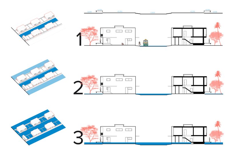
The sectional drawings present three residential adaptation models, each calibrated to a different flood severity. The first shows slightly elevated homes with safe pedestrian zones at grade. The second raises buildings further, accepting controlled street-level flooding while keeping living spaces dry. The third pushes residential floors well above ground, designed to remain habitable even during extreme inundation events. Elevated plinths, split-level planning, and resilient material selections are consistent across all three types. What matters here is the scalability: different communities, different topographies, and different risk profiles can select the typology that fits their conditions without abandoning the larger drainage logic of the neighborhood plan.
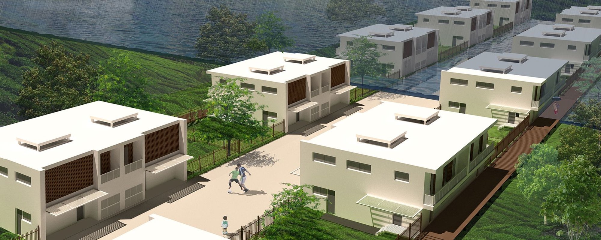
Clear Sky, Storm Sky: The Same Buildings, Two Realities
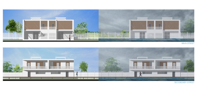
The elevation drawings of the two-storey residential blocks are presented side by side under contrasting sky conditions: calm and clear on one hand, dark and stormy on the other. The pairing is more than atmospheric. It forces the viewer to evaluate whether the architecture holds up under both states. In fair weather, the blocks integrate comfortably into a typical neighborhood streetscape. Under storm conditions, the same buildings remain legible and composed, their elevated bases and resilient detailing ensuring continued habitability. The visual argument is straightforward: flood-resilient design does not require sacrificing everyday livability.
Why This Project Matters
Most flood mitigation strategies operate at the scale of the individual building or the regional drainage system, rarely addressing the neighborhood as a coherent design unit. Popova's project fills that gap by coordinating street grading, landscape retention, and housing typology into a single integrated system. The sunken street is not an afterthought bolted onto a standard masterplan; it is the organizing principle from which every other decision follows.
In an era when climate projections make flood risk harder to ignore, the instinct to build higher walls and bigger pumps persists. "Directing the Flood" offers a more elegant counter-proposal: work with the water. Let it move where it wants to go, give it room to collect, and design the buildings to tolerate its presence. The result is a neighborhood that adapts to natural forces rather than bracing against them, and that is a model worth taking seriously as cities around the world confront the same escalating challenge.
View the Full Project
About the Designers
Designer: Ekaterina Popova
Enter a Design Competition on uni.xyz
uni.xyz runs architecture and design competitions year-round that reward proposals with spatial conviction and real site intelligence.
Project credits: Directing the flood by Ekaterina Popova.


Popular Articles
Popular articles from the community
HCCH Studio Wraps a Shanghai High-Rise Office in Curved Walls of Translucent Glass
A 1,000 square meter fit-out in Lujiazui replaces the typical tech-office palette with layered glass, micro-cement, and quiet rigor.
3dor Concepts Wraps a Kerala Home in Mirrored Concrete Arcs Around a Courtyard Tree
In the Western Ghats foothills of Thamarassery, a 270 m² single-story house uses two curved volumes to frame nature as its center.

RDTH architekti Rips Out Nearly Every Wall in a Prague Apartment and Replaces Them with Furniture
A 101-square-meter post-war flat in Prague trades rigid partitions for a single rotated furniture block, curtains, and glass concrete.

20 Most Popular Office Building Projects of 2025
From biophilic workspaces in India to net-positive energy offices in New Delhi, 20 office building projects that defined architecture in 2025.


Similar Reads
You might also enjoy these articles

Kokaistudios Wraps a Shanghai Retail Podium in Horizontal Louvers That Echo Its Foster + Partners Neighbor
A four-storey glass-roofed gateway links an underground commercial valley to the revitalized north bank of Shanghai's Suzhou River.

Fausto Terán and Toro Fuse Japanese Craft with Mexican Tradition in a Lakeside Retreat
Nakamura House pairs Shou-Sugi-Ban charred pine with handmade clay tile at the foot of Atlangatepec Lagoon in Mexico.
RDTH architekti Rips Out Nearly Every Wall in a Prague Apartment and Replaces Them with Furniture
A 101-square-meter post-war flat in Prague trades rigid partitions for a single rotated furniture block, curtains, and glass concrete.

SWA Group Spirals a Landscape Memorial into the Woods of Sandy Hook
A 1.8-acre clearing in Newtown, Connecticut, honors 26 lives lost with water, stone, and a single sycamore tree.


Explore Sustainable Design Competitions
Discover active competitions in this discipline


The Global Benchmark for Architecture Dissertation Awards


Design challenge to reuse E-waste
Comments (0)
Please login or sign up to add comments
No comments yet. Be the first to comment!