
T.I.M.E. HEALS: Flood-Resilient Architecture That Rebuilds Community in Kerala
A winning HEAL+ entry reimagines Aluva's flood-prone landscape through elevated housing, ecological buffers, and collective infrastructure.


When floodwaters recede in Aluva, Kerala, they leave behind more than ruined interiors and waterlogged farmland. They strip away routines, livelihoods, and the psychological stability that a home is supposed to provide. T.I.M.E. HEALS (Tranquil Interdependent Multifunctional Environment) begins from a premise that most disaster-response housing ignores: reconstruction is not recovery. Recovery requires architecture that holds space for emotional healing, ecological repair, and the reinforcement of social bonds that floods systematically erode.
Designed by Vaishali Sahu, Bhavyata Katyal, Anisha Suri, Meghna Singh, and Jayati Dudani, this project won the HEAL+ competition on uni.xyz. The site is Aluva, a peri-urban region that has faced severe, recurring floods, destroying conventional housing and collapsing transport routes, waste management systems, and agricultural productivity in cascading succession. The designers studied flood dynamics and elevation contours to propose a settlement model where every element, from palm plantations to overhead water tanks, performs multiple roles across the spectrum of disaster preparedness, crisis response, and long-term resilience.
Reading the Terrain: Contours as Design Infrastructure
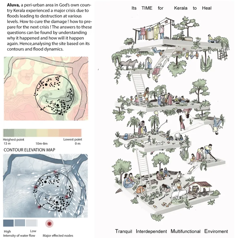
The project's foundation is topographic. An axonometric drawing maps the site's contour elevations, revealing how water moves through Aluva during flood events. Rather than fighting the terrain, the designers use it as a generative constraint: terraced communal platforms follow the natural grade, creating elevated gathering zones that remain above typical flood lines. The watercolor sketch paired with the contour analysis signals something important about the team's methodology. They are not simply engineering flood barriers; they are shaping a social landscape where the ground itself determines where people congregate, cultivate, and find refuge.
Laterite Walls and False Monoliths: A Material Language for Resilience
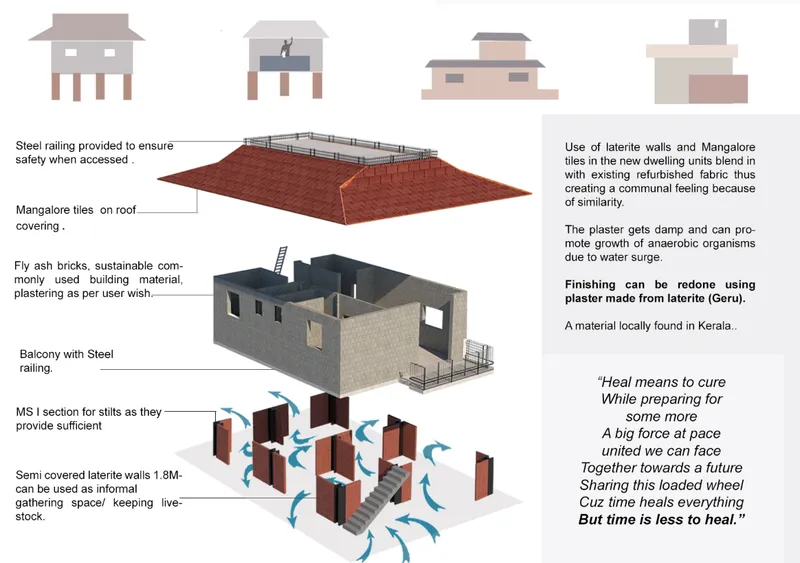
The exploded axonometric is the project's most information-dense drawing. It dissects the dwelling unit into its constituent systems: stilt foundations that lift living spaces above surge levels, laterite walls that handle moisture without degrading, fly ash bricks for structural infill, Mangalore tile roofing, and ventilation strategies calibrated for Kerala's humid climate. The material palette is both ecologically and economically grounded, sourcing locally available resources that communities can maintain without specialized labor. For the most vulnerable existing homes, the designers propose retrofitting with false monolithic walls, surfaces designed to redirect turbulent floodwaters around structures rather than through them.
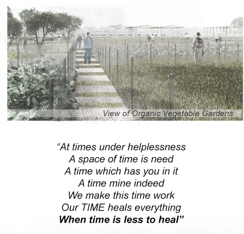
Adjacent to the housing, elevated walkways thread through organic vegetable gardens enclosed with wire mesh fencing. These are not decorative gestures. The gardens address food security directly, reducing dependence on external supply chains that collapse during flood events. The rendering shows residents tending crops at a comfortable working height, the raised beds doubling as a strategy to keep root systems above saturated soil. Alongside these, floating farms are proposed for waterlogged areas, turning the flood's aftermath into a productive landscape rather than a wasteland awaiting cleanup.
Clustered Stilts and Circulation Nodes: The Network as Safety System
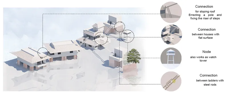
The isometric diagram of clustered housing on stilts reveals the project's spatial logic at the settlement scale. Individual units are not isolated objects; they are connected through a network of circulation nodes, pathways, and ladder systems that enable rapid evacuation and mutual aid during rising waters. Multi-functional machaans, elevated watchtowers, serve as both lookout points and communal gathering hubs. Overhead tanks perform a dual role as water storage and emergency meeting spaces. The interdependence is structural, not rhetorical. Each dwelling's safety depends on its connection to the network, which means construction and maintenance become shared responsibilities. Local training centers, proposed as part of the program, teach residents to produce lightweight, foldable furniture designed to be quickly moved or stored when floods approach.
The Refuge Tower: Vertical Safety in a Horizontal Crisis
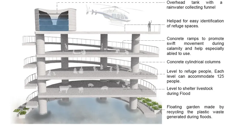
The sectional model of the multi-level flood refuge tower is perhaps the project's most striking single element. Concrete ramps wind upward through a column-and-slab structure, providing accessible vertical evacuation routes without relying on stairs or ladders that become impassable for the elderly or disabled during emergencies. At the top, an overhead water tank anchors the structure's utility during normal conditions, storing water for daily community use. During floods, the tower becomes a gathering and staging point, its multiple levels accommodating different functions: shelter below, coordination above. The designers have embedded emergency infrastructure into the everyday fabric of the settlement, so that the moment of crisis does not require a sudden shift to unfamiliar spaces.
Before, During, After: A Settlement That Adapts Across Time
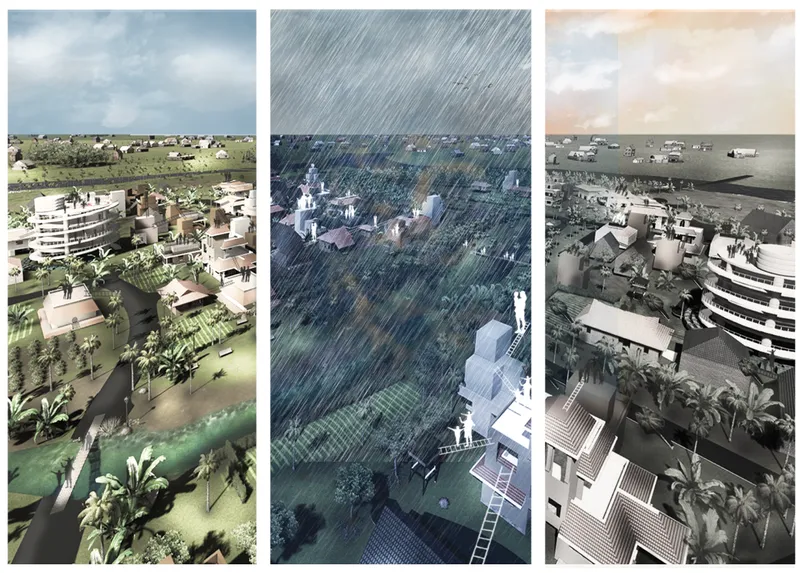
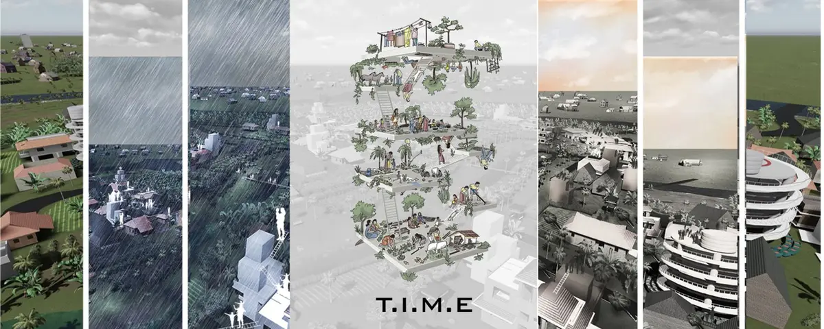
Three renderings track the settlement through its most critical temporal sequence: before flooding, during heavy rainfall, and after the water recedes. In the first frame, the community operates as a productive, inhabited landscape. In the second, elevated walkways, stilted housing, and refuge towers demonstrate their purpose as water rises around them. In the third, the settlement returns to function quickly because its key systems, gardens, pathways, dwelling units, were designed to survive immersion. Palm plantations line the site, reducing soil erosion and serving as navigation markers when water obscures the ground plane. The sequence makes a powerful argument: resilient design is not about preventing disaster but about compressing the recovery timeline.
Why This Project Matters
T.I.M.E. HEALS refuses the common framing of disaster housing as a logistics problem solved by standardized shelters dropped onto damaged sites. Instead, it treats the flood as a recurring condition that architecture must negotiate over years and decades, not just survive once. The integration of ecological systems (floating farms, palm plantations, organic gardens) with physical infrastructure (refuge towers, stilted clusters, networked pathways) produces a settlement that gets more resilient as it matures, because its living components grow stronger with time.
What elevates the project beyond competent disaster planning is its insistence on emotional and social repair as design objectives. Spaces for gathering, learning, and collective cultivation are not afterthoughts; they are primary program elements placed on equal footing with structural flood resistance. For Aluva, where recurring disasters have eroded not just buildings but the confidence of communities, that rebalancing is exactly what healing architecture should look like.
View the Full Project
About the Designers
Designers: Vaishali Sahu, Bhavyata Katyal, Anisha Suri, Meghna Singh, Jayati Dudani
Enter a Design Competition on uni.xyz
uni.xyz runs architecture and design competitions year-round that reward proposals with spatial conviction and real site intelligence.
Project credits: T.I.M.E. (Tranquil Interdependent Multifunctional Environment) HEALS by Vaishali Sahu, Bhavyata Katyal, Anisha Suri, Meghna Singh, Jayati Dudani HEAL+ (uni.xyz).


Popular Articles
Popular articles from the community


Aquadapt: An Underwater Habitat That Rewrites Its Rooms by the Hour
Curved modules ring the seabed while one shell shifts from breakfast room to cinema, farm and football pitch as residents' needs change.
Opera on the Sea: Driftwood Logic Shapes a Timber Opera House on Estonia's Coast
Trevor Orgill's opera house translates the entangled drift of floating timber into a civic building where wood, water, and music converge.

Singing Woman: An Opera House That Performs Before the Curtain Rises
Ovidiu Cristian Pavel's conceptual opera house translates Estonia's choral identity into a sculpted waterfront landmark facing the Baltic Sea.


graciastudio Turns a Viewless Tijuana Lot Inward Around a Courtyard of Concrete, Timber and Trees
In Tijuana, Jorge Gracia's GA2 House stacks a timber-clad private floor over exposed concrete and replaces a missing view with a planted interior patio.

Similar Reads
You might also enjoy these articles

Cube Design Draws an Ecological Corridor Between Two Shenzhen Hills with the Nankai Building
Beside Shenzhen's container docks, the Nankai Building pairs stacked balconies with a climbing green screen to connect two hillsides across its height.

Praksis A and Studio Sted Bend a Red Timber Cabin Across the Granite of Norway's Southern Coast
On the southern Norwegian coast, a 105 m² cabin follows the rock on slender posts, pairing red cladding outside with pine, brick and plywood within.

David Ortega Stacks a Two-Story Mexico City Penthouse Around a Steel Stair and a Pergola-Shaded Roof Terrace
In Colonia Roma, a 300 m² penthouse uses oak joinery, a planted steel stair and a slatted roof pergola to make a new-build apartment feel like a house.

PARALELA and LB2 Thread a Public Walkway Through the Base of a Las Condes Residential Tower
In Las Condes, Santiago, the Hamlet Building gives its fenceless ground floor to a 70-metre wooded passage linking two streets and the metro.

Comments (0)
Please login or sign up to add comments
No comments yet. Be the first to comment!