
Structuring the Urban Form with Natural Systems
A climate‑responsive urban planning thesis that reimagines mountain city growth by structuring urban form around natural water systems.
Mountain cities across the world represent some of the most complex and fragile urban environments. Defined by steep terrain, limited developable land, climatic sensitivity, and constrained infrastructure, these settlements face challenges that are fundamentally different from cities located in plains. With increasing urbanization, population pressure, and climate stress, conventional urban planning models often fail when applied to mountainous contexts. This thesis, Structuring the Urban Form with Natural Systems, proposes a sustainable urban planning strategy for mountain cities by organizing growth around natural water systems rather than resisting them.
Developed as an academic thesis by Rohit Raj, the project investigates how natural systems: particularly water catchments, topography, slope gradients, and ecological networks, can become the primary structuring framework for future urban expansion. The study is rooted in the Himalayan city of Shimla, India, a historic hill settlement experiencing acute pressure on land, water, housing, and infrastructure.
Understanding Mountain Cities and Their Urban Challenges
Mountain cities are shaped by constraints rather than freedom of expansion. Steep slopes restrict horizontal growth, while fragile ecosystems demand sensitive intervention. Shimla, like many hill towns, originally developed along ridgelines for climatic comfort, views, and defense. Over time, unregulated expansion, population growth, and infrastructure overload have disrupted the balance between the built environment and natural systems.
The thesis identifies key challenges faced by mountain cities:
- Scarcity of drinking water and inefficient distribution systems
- Development on steep slopes leading to environmental degradation
- Dependence on energy‑intensive pumping systems
- Fragmented urban growth without ecological integration
- Housing shortages due to limited buildable land
Rather than treating these conditions as obstacles, the project reframes them as design generators for sustainable urban planning in mountain cities.
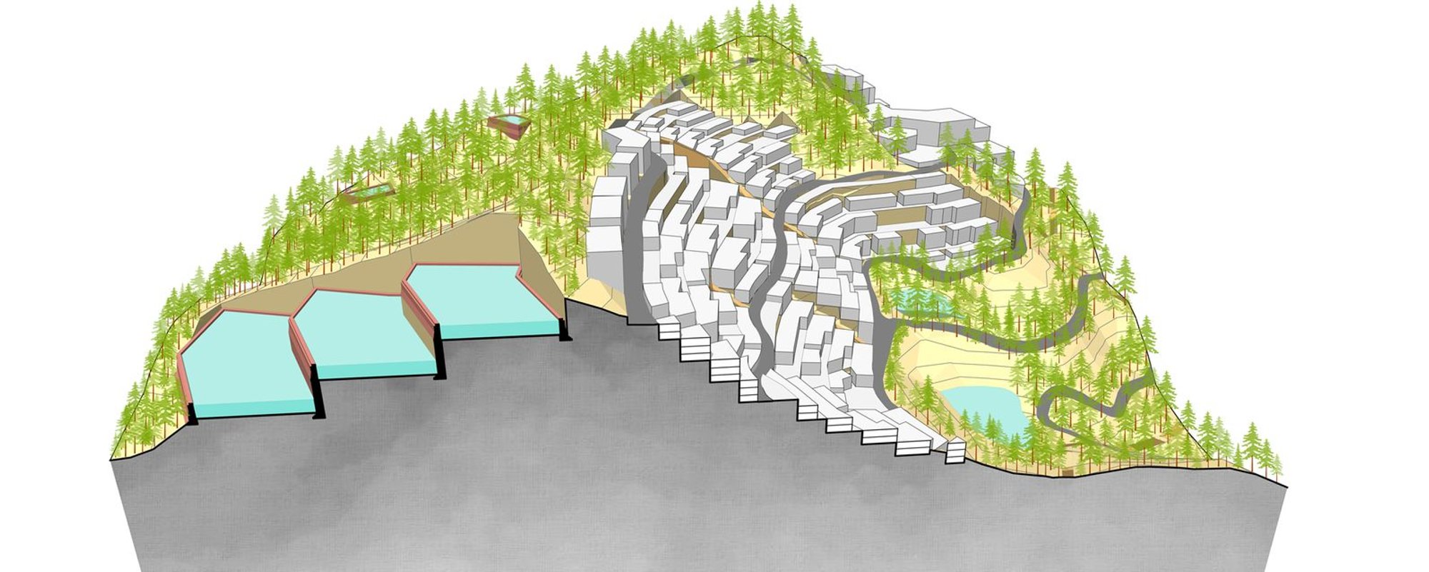
Water as the Primary Urban Structuring Element
At the core of the thesis lies the idea that water systems should guide urban form. In mountain terrains, water naturally flows from higher catchment zones to lower valleys, forming streams, drainage lines, and seasonal runoff patterns. Historically, settlements that respected these systems were more resilient, while contemporary development has often disrupted them.
The project begins with an in‑depth analysis of Shimla’s natural water networks, including:
- Watershed boundaries
- Catchment basins
- Seasonal streams and runoff paths
- Rainfall data and surface runoff potential
By mapping and quantifying these systems, the thesis establishes water as a spatial and infrastructural backbone rather than a hidden utility. Urban functions are then distributed according to their water demand, allowing gravity‑based distribution and minimizing energy consumption.
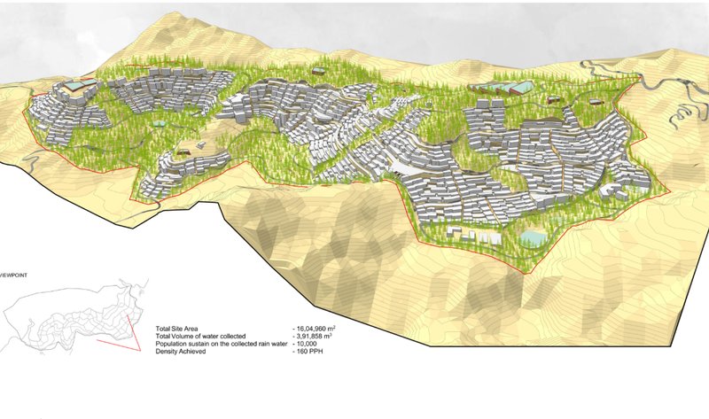
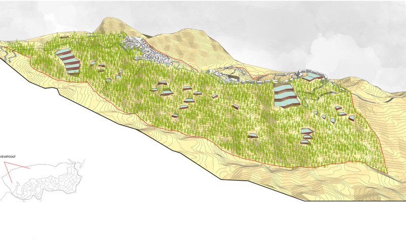
Site Selection and Regional Context
The proposed intervention site lies near Jathia Devi, along the highway connecting Shimla to surrounding regions. This location is strategically positioned within the regional settlement network while remaining environmentally sensitive. A regional‑scale analysis studies settlement patterns, transportation corridors, forest cover, and topography to ensure that the proposal integrates with broader ecological and urban systems.
The site is carefully delineated based on:
- Non‑developable forest zones
- Water catchment areas
- Slope suitability
- Solar orientation
- Existing access routes
More than half of the site is preserved as non‑developable land, reinforcing the principle that sustainable urban planning in mountain cities must prioritize ecological conservation over built density.
Topography‑Driven Urban Zoning
Instead of imposing a rigid grid, the urban form follows the contours of the land. Development is concentrated on south‑facing slopes that receive maximum sunlight, while north‑facing slopes are preserved for water catchment and forest regeneration. This slope‑based zoning strategy ensures climatic comfort, reduces excavation, and protects natural drainage.
Key zoning principles include:
- Dense forest zones designated as water catchment areas
- Residential clusters aligned along contours
- Institutional and public buildings located on gentler slopes
- Commercial zones positioned along ridge roads
This approach allows the city to grow in harmony with the terrain rather than against it.
Sustainable Water Collection and Distribution
One of the most critical aspects of the proposal is its integrated water management system. Rainwater is collected across the catchment zones using surface runoff channels and check dams strategically placed along natural valleys. These systems store water, reduce erosion, and recharge groundwater.
Water distribution follows a gravity‑based model:
- Water is collected at higher altitudes
- Filtered at treatment stations
- Distributed across the settlement without energy‑intensive pumping
By eliminating the need to pump water uphill: a major issue in Shimla: the system significantly reduces energy consumption, infrastructure costs, and water loss.
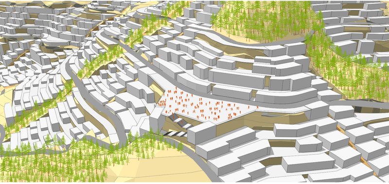
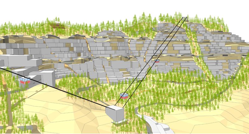
Road Networks and Pedestrian‑First Planning
Vehicular roads follow contour lines to reduce slope gradients and excavation. A loop road system connects major zones, ensuring efficient public transport movement while limiting vehicular penetration into residential areas.
In contrast, pedestrian streets follow natural water streams. These pedestrian corridors double as social spaces, drainage channels, and ecological buffers. Designed with steps, ramps, and terraces, they adapt seamlessly to steep slopes while encouraging walking and community interaction.
This pedestrian‑oriented approach enhances walkability and reinforces the social fabric of the neighborhood.
Neighborhood Clusters and Housing Typologies
Housing is organized into compact neighborhood clusters designed to maximize density without overwhelming the landscape. Buildings step down the slope, ensuring that no structure blocks sunlight or views of another.
The residential typologies emphasize:
- Shared walls for thermal efficiency
- Terraced forms responding to slope
- Mixed heights to avoid socio‑economic segregation
- Integration of open spaces within clusters
These clusters balance affordability, density, and environmental sensitivity, key pillars of sustainable urban planning in mountain cities.
Mixed‑Use and Institutional Integration
To reduce travel distances and promote self‑sufficient neighborhoods, mixed‑use buildings are introduced along key pedestrian streets. Ground floors accommodate local markets, workshops, and services, while residences occupy upper levels.
Institutions such as schools and healthcare facilities are located along outer access roads on flatter terrain, ensuring easy accessibility without disturbing residential zones. Buffers of vegetation and open spaces maintain a peaceful environment.
Masterplan Vision and Urban Resilience
The final masterplan presents a cohesive vision where built form, landscape, water systems, and mobility networks function as a single integrated system. Forests, water bodies, and open spaces are not residual areas but fundamental components of the urban structure.
By aligning urban growth with natural systems, the proposal demonstrates how mountain cities can expand sustainably while preserving ecological balance and improving quality of life.
Structuring the Urban Form with Natural Systems offers a forward‑looking framework for sustainable urban planning in mountain cities. By treating water and topography as organizing principles rather than constraints, the thesis challenges conventional planning models and proposes an ecologically grounded alternative.
In the face of climate change, resource scarcity, and rapid urbanization, such approaches are no longer optional but essential. This project stands as a strong academic and design response to the future of mountain city development, where nature and urbanism evolve together rather than in conflict.


Popular Articles
Popular articles from the community
Cafe MADA: A Chiang Rai Pavilion in a Mango Orchard
BodinChapa Architects threaded a 254 m² black-roofed cafe through an existing mango orchard in Chiang Rai, Thailand, built around mature trees.

Art 1 Office Strips Athens Back to Its Bones
Neiheiser Argyros transforms a 40-year-old Athens office building into a vivid, materially rich workplace anchored by red steel, exposed concrete, and roof
Residence BB 214: Quiet Precision in Ludhiana
Minimalist Architecture & Design Studio composes a residence of white volumes, filtered light, and deliberate restraint in Punjab's urban fabric.
A Park Building That Wants to Be a Landscape
Omrania's Operations & Maintenance Building at King Salman Park dissolves industrial program into Riyadh's largest green infrastructure.
Similar Reads
You might also enjoy these articles

Twilight Crossing: A Pedestrian Bridge That Performs with Light and Water
Angel Gamboa's tensile cable bridge transforms a lakeside crossing into a choreographed sequence of color, reflection, and framed views at dusk.
Digital Façade Design for our cities’ urban fronts
Prima Facie - Result Story
Protecting avian biodiversity: Bird observatories to help spread awareness & save rare bird species.
Results for ‘Fly’ - Landscape design competition out now


Comments (0)
Please login or sign up to add comments
No comments yet. Be the first to comment!