

Super CP: Rewriting New Delhi's Colonial Core as a Multilayered Smart District
A competition-winning proposal transforms Connaught Place from imperial relic into an ecologically integrated, hyperconnected urban center.


Connaught Place was designed in 1933 as the commercial nucleus of imperial New Delhi: a radial plan locked into colonial symbology, rigid zoning, and a singular idea of civic life. Nearly a century later, that same geometry persists, but the context around it has shifted beyond recognition. Vehicular congestion chokes its arcades, fragmented commercial use has eroded its public character, and decades of haphazard expansion have left its middle ring underutilized. Super CP takes this diagnosis seriously and proposes not a renovation but a full spatial rewrite, layering ecological infrastructure, next-generation mobility, and adaptive reuse onto the bones of one of India's most iconic urban forms.
Designed by Anjali Singh, Anas Ahmed, Kiran Bhamidipati, and Abdul Bari, Super CP won the Neo Delhi competition on uni.xyz. The brief asked entrants to reimagine Delhi for a future shaped by climate stress, technological acceleration, and social complexity. This team responded with a scheme that treats Connaught Place's concentric rings as an armature for a multilayered Central Business District: one that is pedestrian-first, ecologically active, and connected by systems ranging from AI-managed internal transport to Hyperloop access.
Reading the Rings: From 1933 to the Age of Accelerations
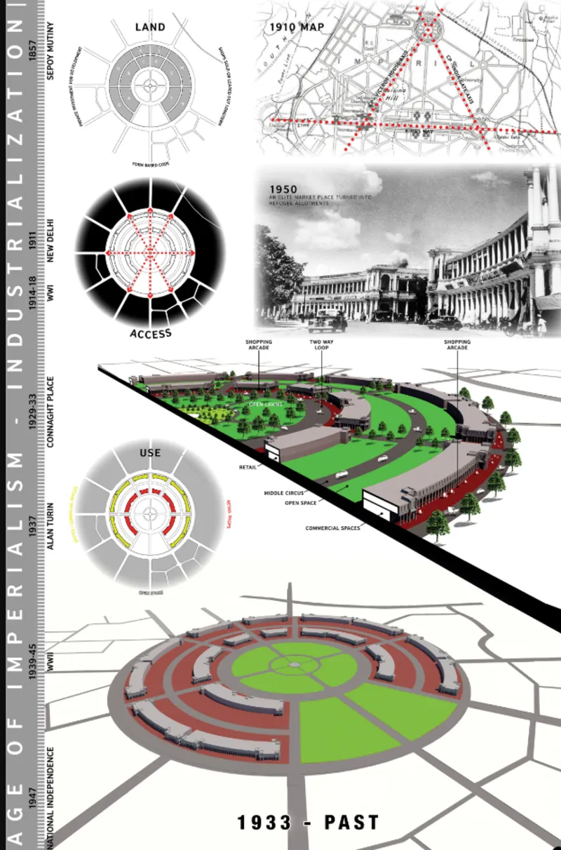
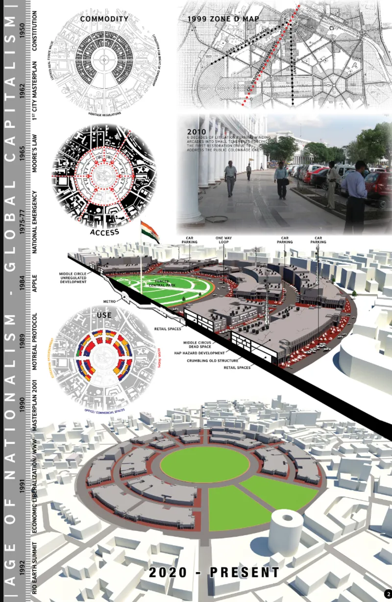
The project's analytical boards lay out a clear temporal arc. The first composite traces Connaught Place from its 1933 master plan through the congestion of the 1990s and early 2000s to what the designers call the "Age of Accelerations," a present moment where the site can be reconceived as a smart, sustainable fabric. Historical photographs sit alongside axonometric projections, making the case that CP's radial geometry is not the problem; its mono-functional programming and car-dominated circulation are. The second board zooms into the street condition, documenting the friction between pedestrians, vehicles, and fragmented retail at ground level before proposing a reorganized section with dedicated drop-off zones and micro-mobility corridors.
What makes this diagnostic phase convincing is its specificity. Rather than treating CP as a blank canvas, the designers parse each concentric ring for its current failures and latent potential. The outer ring retains its role as a transit interface, but the middle ring, long the most degraded zone, becomes the epicenter of transformation. This is where hybrid programming (co-working spaces, retail pods, cultural zones) is introduced beneath a glazed canopy structure with internal circulation decks.
An Urban Forest Where the Central Park Used to Be
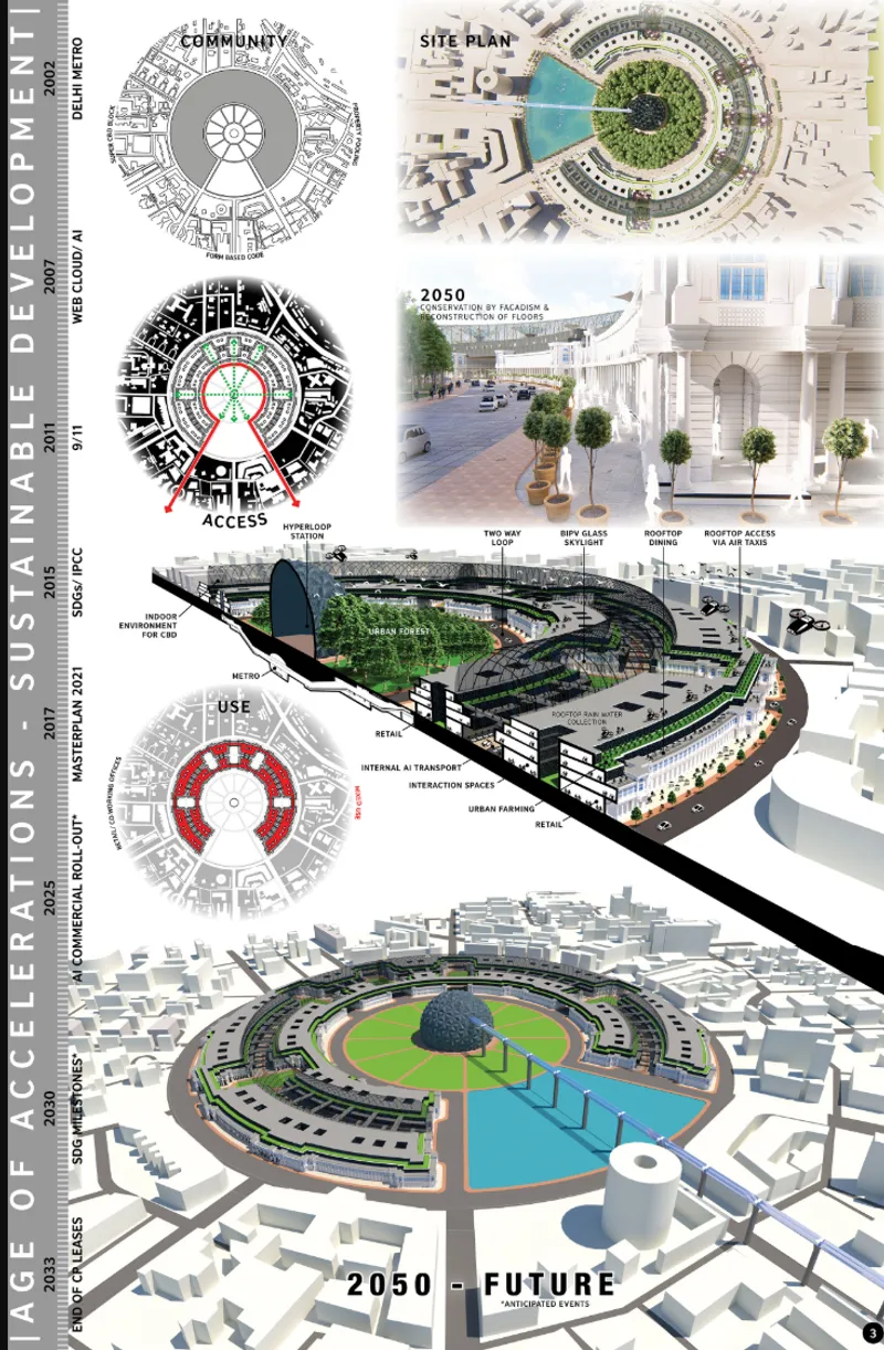
The site plan and axonometric projections on the third board reveal the project's most dramatic move: replacing Connaught Place's traditional central park with a dense urban forest. This is not decorative greening. The designers position the forest as a "natural lung" for the city center, an ecological engine surrounded by dynamic courtyards, public walkways, and water features that collectively prioritize pedestrian life over vehicular throughput. Green roofs extend across the surrounding structures, weaving planted surfaces into the architecture rather than confining them to ground-level planters.
The radial site plan reads as a series of concentric environmental gradients: dense canopy at the core, transitioning through shaded courtyards and green-roofed pavilions toward the outer transport ring. It is a spatial sequence that pulls people inward toward nature rather than pushing them outward toward roads. Rooftop farming is integrated into the upper levels, adding a productive agricultural layer to what is otherwise a commercial district.
Vertical Gardens Between Heritage Colonnades
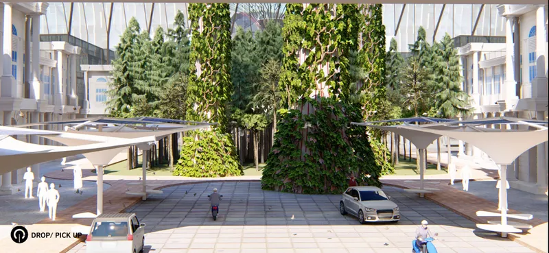
The courtyard perspective is where Super CP's ambition becomes tangible. Vertical green walls climb between white canopy structures, and the paved surface at ground level is scaled for walking, not driving. The iconic colonnades of Connaught Place are retained but grafted with green facades and vertical gardens, creating what the designers describe as a "seamless dialogue between heritage preservation and sustainable architecture." The result is a space that feels simultaneously rooted in the geometry of the original plan and detached from its colonial austerity.
The human figures in the rendering are not incidental. They demonstrate the scale the designers are working at: intimate, street-level, navigable on foot. Drop-off points and AI transport handle arrivals, but once inside the rings, movement belongs to people. It is a simple principle, but one that Connaught Place has struggled to achieve for decades.
A Glazed Canopy and Skywalks for Vertical Connectivity
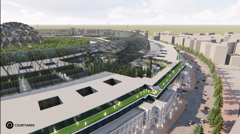
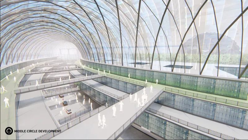
The aerial perspective reveals the structural ambition of the middle-ring intervention: a curved, glazed canopy defined by a diagonal structural grid that spans over tiered courtyard buildings. This is the connective tissue of Super CP, housing the hybrid programming that replaces the degraded commercial zones and linking outward to skywalks that enable vertical interaction across the concentric rings. The diagonal grid is both structural and expressive, giving the canopy a legibility that distinguishes new intervention from retained heritage fabric.
The interior view beneath the arched glass-and-steel roof confirms that the canopy is not merely a cover but a climate-modifying device. Planted courtyards sit below the glazing, daylight filters through the structural lattice, and the section accommodates multiple levels of pedestrian circulation. Hyperloop access and integrated transport networks are threaded beneath and around the district, reducing dependence on personal vehicles while connecting CP to a city-scale mobility system. The space reads as part greenhouse, part station concourse, part public garden: a genuinely multi-layered interior that earns the prefix "Super."
Why This Project Matters
Super CP refuses the incremental upgrade. Instead of resurfacing colonnades or adding a metro exit, it asks what Connaught Place could become if its concentric geometry were treated as infrastructure for ecological, social, and technological systems that did not exist when the plan was drawn in the 1930s. The answer is a dense, walkable, vertically connected district where heritage fabric coexists with green walls, glazed canopies, rooftop farms, and hyperloop platforms. It is speculative, certainly, but it is speculative with spatial precision.
For Delhi, a city simultaneously confronting extreme heat, chronic congestion, and rapid growth, the project offers a provocation worth taking seriously. The designers demonstrate that India's most recognizable commercial center does not need to choose between preservation and transformation. It can do both, provided the design operates across enough layers, from the underground transit network to the planted roofscape, to give a century-old plan a genuinely new purpose.
View the Full Project
About the Designers
Designers: Anjali Singh, Anas Ahmed, Kiran Bhamidipati, Abdul Bari
Enter a Design Competition on uni.xyz
uni.xyz runs architecture and design competitions year-round that reward proposals with spatial conviction and real site intelligence.
Project credits: Super CP by Anjali Singh, Anas Ahmed, Kiran Bhamidipati, Abdul Bari Neo Delhi (uni.xyz).


Popular Articles
Popular articles from the community

Manzana Morphosis: Stretching Barcelona's Grid into a Living Landscape for 2050
A radical reworking of the Eixample manzana turns density into a tool for generous public space, vertical ecology, and environmental performance.

Cloaked Colonization: A Mobile Underwater Habitat That Moves Like a Fish
Micah Abaya's shortlisted EHC Pacific entry reimagines ocean settlement as a dispersed network of self-sustaining architectural organisms.
Faces of the Soviet Avant-Garde: Turning Moscow's Street Names into an Open-Air Museum
A network of sculptural installations across a Moscow residential district transforms forgotten architect names into spatial encounters with cultural memor
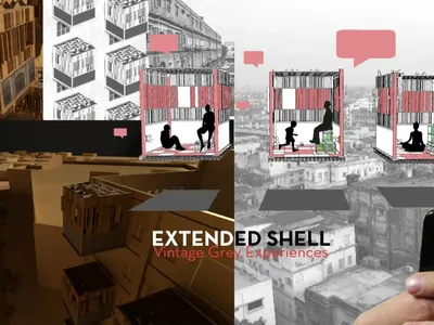
Extended Shell: Retrofitting Kolkata's Balconies as Living Urban Thresholds
A modular retrofit system recovers the social and environmental intelligence of Kolkata's historic verandas for contemporary Park Street residents.

Similar Reads
You might also enjoy these articles

Shakur's House: Exposed Brick as an Interior Organiser in a 168 m² Mashhad Residence
Brick moves indoors in this Mashhad residence, where masonry walls, glass partitions and teal planes sequence a compact home without closing it off.
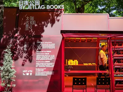
Day and Night Park: A Time-Based Urban Newsstand in Beijing
A temporary urban newsstand in Beijing blending travel, light, and reading through poetic colors, compact form, and community-focused design.

Modernist Patio Renovation in El Masnou, Barcelona by Oliver Segura Arquitectura + Cebrià Arquitectura
Modernist patio renovation blending tradition and innovation with a movable pool, leveled floors, and Catalan materials in El Masnou.
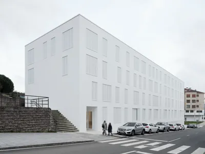
Alto Residencial Coop: Cooperative Housing Development in Santiago de Compostela by Carbajo Barrios Arquitectos
A linear cooperative housing complex blending white volumes and perforated metal façades, enhancing community living, natural light, privacy, and urban integration.

Comments (0)
Please login or sign up to add comments
No comments yet. Be the first to comment!