

Depressive Coastal Territories Development: Regenerating Sestroretsk's Forgotten Waterfront
A data-driven urban strategy layers ecological corridors, wellness programs, and adaptive reuse across a historic Baltic resort town's coastline.


A town founded in 1714 as Peter the Great's summer retreat on the Gulf of Finland should not be depressive. Yet Sestroretsk, once the jewel of Baltic resort culture, arrived at the 21st century with an underused waterfront, post-industrial decline, and aging infrastructure slowly being swallowed by pine forests and sand dunes. The question this project asks is pointed: how do you regenerate a coastal territory without bulldozing the very qualities that made it worth visiting in the first place?
Designed by Елена Панфилова and recognized as an Editor's Choice entry in UnIATA 2020, the project treats Sestroretsk as a full-scale case study in urban regeneration architecture. Located just north of Saint Petersburg along the Baltic shore, the town retains traces of its imperial gardens, 19th-century railway links, Soviet-era sanatoriums, and children's camps. Panfilova's proposal reads these layers as assets rather than obstacles, structuring a regeneration plan that integrates climate resilience, ecological zoning, and year-round public programming across the entire coastal strip.
Mapping Three Centuries of Coastal Identity
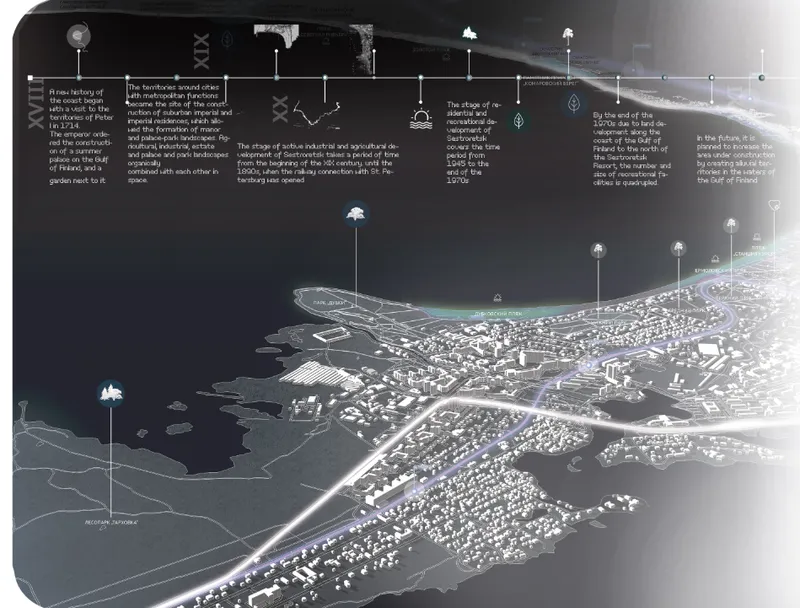

The project's analytical foundation is rigorous. An annotated axonometric timeline traces Sestroretsk's evolution from imperial palace grounds through 20th-century recreational infrastructure to projected future amenities, plotting each phase spatially along the waterfront. A companion circular data visualization diagram organizes the town's programmatic DNA into concentric rings of information: ecology, transport, wellness, culture, and residential density radiate outward from a central point. Together, these drawings argue that regeneration must be legible before it can be buildable. Every proposed intervention is anchored in documented historical and environmental conditions.
This data-driven approach sets Panfilova's work apart from more intuitive resort-town masterplans. The visual analytics serve a dual purpose: they communicate complexity to policymakers and urban stakeholders, and they discipline the design itself, preventing arbitrary gestures. The timeline drawing in particular reveals how railway access in the 19th century catalyzed the sanatorium district, a pattern the proposal seeks to replicate by leveraging contemporary mobility networks to reactivate dormant waterfront zones.
Layered Urbanism: Stacking Program Over Ecology

An exploded axonometric drawing reveals the project's organizational logic with clarity. Blue and grey urban blocks separate and lift apart to expose the layers beneath: ecological corridors, public space networks, wellness centers, educational institutions, cultural hubs, and residential neighborhoods are each given their own stratum. Icon annotations above each block identify specific programs, making the drawing function almost as an instruction manual for multi-functional zoning. The ecological backbone of coastal dunes and pine forest remains at the base, undisturbed, while built interventions stack above it in a carefully calibrated hierarchy.
What this layering strategy achieves is a form of urban insurance. By distributing programs across distinct but interconnected zones, the plan ensures that no single function dominates the waterfront. Wellness programs sit alongside cultural anchors; residential neighborhoods share edges with restored green belts. The result is a cohesive, community-oriented framework where each intervention acknowledges the site's past while supporting adaptability for future conditions, including rising sea levels and shifting demographic needs.
A Promenade That Earns Its Coastline
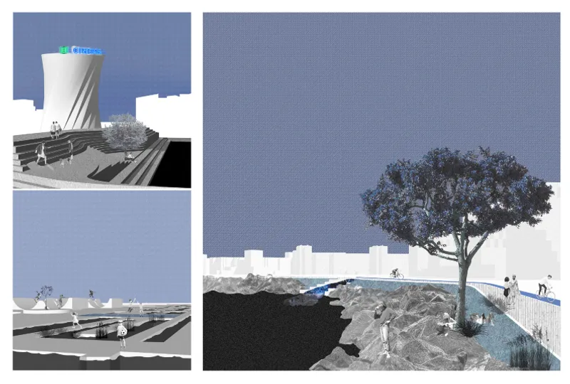
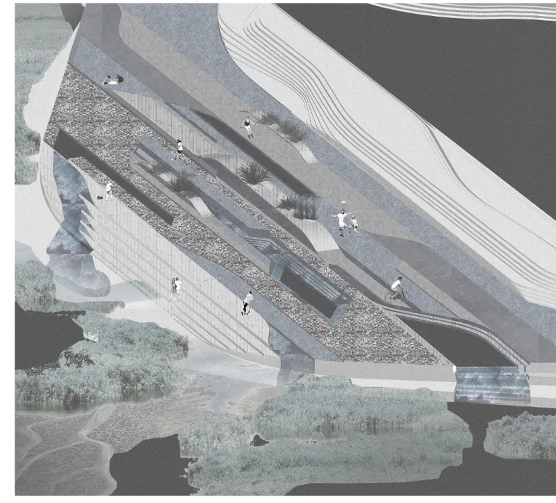
The collage rendering of the coastal promenade offers a glimpse of the project's atmospheric ambition. Pedestrians move beneath mature trees against a wide Baltic sky, and the scene feels unhurried, almost meditative. It is a deliberate contrast to the hyper-programmed waterfronts that have become default in many regeneration schemes. The aerial plan view confirms that this restraint is designed, not accidental: planted beds and paving bands alternate in a linear rhythm along the waterfront plaza, creating distinct zones for walking, gathering, and resting without resorting to walls or barriers.
These two drawings together demonstrate how the project handles public engagement at the ground plane. Vacant and underutilized sites along the coast are reinterpreted as cultural and recreational anchors, activated year-round through careful material choices and spatial proportions. The architectural vocabulary embraces local materials, passive design strategies, and low-carbon technologies. The promenade is not decoration; it is infrastructure, stitching together eco-corridors and reactivated coastlines into a continuous public sequence.
Terraced Topography at the Harbor Edge

A white physical model captures the project's most architecturally resolved moment: a terraced waterfront district that steps down toward the harbor edge, punctuated by circular forms that break the linearity of the coastline. The model reveals how building massing mediates between the town's interior and the open water, creating sheltered public spaces at multiple elevations. The terracing also functions as a climate-responsive strategy, managing stormwater runoff and wind exposure while maximizing views toward the Gulf of Finland.
The circular elements read as gathering nodes or civic markers, their geometry contrasting with the orthogonal grain of the surrounding blocks. In a project that could easily remain abstract at the masterplan scale, this model demonstrates that Panfilova has thought through the experience of arrival at the water's edge. The harbor district is both a spatial culmination and a programmatic anchor, the place where the project's interconnected pathways, green belts, and cultural programs converge.
Why This Project Matters
Coastal regeneration projects frequently oscillate between two failures: they either erase local identity in pursuit of generic waterfront development, or they preserve heritage so cautiously that nothing new can take root. Panfilova's proposal for Sestroretsk navigates between these extremes with discipline. By grounding every design move in historical analysis and environmental data, the project builds a credible argument for regeneration as a layered, incremental process rather than a singular architectural gesture.
The work also raises a productive question for architects and urbanists working on depressive coastal territories worldwide: what does it mean to treat a town's decline as legible material for design? Sestroretsk's sanatoriums, pine forests, and railway links are not just nostalgic references. In Panfilova's framing, they are structural components of a climate-responsive, socially equitable urban future. The project positions this small Baltic town as a forward-thinking model for how heritage, ecology, and public life can coexist at the water's edge.
View the Full Project
About the Designers
Designer: Елена Панфилова
Enter a Design Competition on uni.xyz
uni.xyz runs architecture and design competitions year-round that reward proposals with spatial conviction and real site intelligence.
Project credits: DEPRESSIVE COASTAL TERRITORIES DEVELOPMENT by Елена Панфилова UnIATA 2020 (uni.xyz).




Popular Articles
Popular articles from the community

The Musturak Paradise: Senior Living Architecture for a Connected Future in Temara, Morocco
The Musturak Paradise reimagines senior living architecture in Temara via private homes, social spaces, culture, community, and shared care.

AL-JANNAH: Sustainable Architecture and Permaculture for Afghan Widows
AL-JANNAH uses sustainable architecture and permaculture to create resilient oasis of housing, learning, work and renewal for Afghan widows.
Riyadh For All: Intergenerational Urban Design for Active Aging in Rabat
Riyadh For All reimagines urban design in Rabat with intergenerational co-living, adaptive courtyards, and Moroccan cultural exchange today.

Co-life: Sustainable Architecture for Age-Friendly Community Living
Co-life reimagines sustainable architecture for seniors through courtyards, rammed earth, shared gardens, and spaces designed for belonging.


Similar Reads
You might also enjoy these articles

Day and Night Park: A Time-Based Urban Newsstand in Beijing
A temporary urban newsstand in Beijing blending travel, light, and reading through poetic colors, compact form, and community-focused design.

Modernist Patio Renovation in El Masnou, Barcelona by Oliver Segura Arquitectura + Cebrià Arquitectura
Modernist patio renovation blending tradition and innovation with a movable pool, leveled floors, and Catalan materials in El Masnou.
Alto Residencial Coop: Cooperative Housing Development in Santiago de Compostela by Carbajo Barrios Arquitectos
A linear cooperative housing complex blending white volumes and perforated metal façades, enhancing community living, natural light, privacy, and urban integration.
Vil Genis School by BPA ARCHITECTURE – Massy, France
Vil Genis School in Massy, France, features sustainable design, south-facing classrooms, community integration, accessible spaces, and modern educational architecture.





Comments (0)
Please login or sign up to add comments
No comments yet. Be the first to comment!