


Green Infrastructure
Design work that uses vegetation, water, and soil systems as urban infrastructure, from stormwater and parks to reclaimed land and civic open space.
Green infrastructure is a planned network of green and blue spaces, such as parks, street trees, bioswales, green roofs, wetlands and river corridors, that cities design to do the work of infrastructure. Instead of piping rain away or air conditioning their way out of heat, they use soil, plants and water to hold stormwater, cool streets, shelter wildlife and give people healthier places to live. The idea treats landscape as a working system that deserves the same planning, budget and maintenance as roads and sewers.
What is green infrastructure?
The term covers any vegetated or water-based system that is deliberately planned to deliver services a city would otherwise buy from concrete, pipes and machines. The European Commission describes it as a network of green (land) and blue (water) spaces that improves environmental quality, the connectivity of natural areas, and citizens' health and quality of life. In the United States, the Environmental Protection Agency focuses on water: rain gardens, planter boxes, green roofs and permeable pavements that reduce and treat stormwater where it falls, before it can carry pollutants into rivers and lakes.
"A strategically planned network of natural and semi-natural areas with other environmental features, designed and managed to deliver a wide range of ecosystem services, while also enhancing biodiversity."
Two words in that definition matter most: network and planned. A single pocket park is welcome, but it only becomes green infrastructure when it connects to other spaces and is designed to perform, for instance by taking runoff from the street next to it. That is where the field differs from adjacent disciplines. Landscape architecture designs individual places; green infrastructure is a planning strategy that links those places into a system across a district, a city or a region. It overlaps heavily with urban ecology, which studies how species and processes behave in cities, and with blue infrastructure, the rivers, ponds and wetlands that the same network has to make room for. You will often see the combined phrase blue-green infrastructure for exactly that reason.

A short history of green infrastructure
The phrase is young, but the thinking behind it is more than a century old. Frederick Law Olmsted (1822 to 1903), whom the US National Park Service calls the founder of American landscape architecture, planned Boston's Emerald Necklace as a linked chain of parks rather than a set of separate greens. In 1880 he proposed that the Muddy River, which ran from Jamaica Pond through the Fens, be included in the park plan. The work began around 1878 as an effort to clean up and control the marshy land that became the Back Bay and the Fens, so the scenery was also a piece of water management. The system still runs for about 7 miles of parkland today. It is the classic early example of a park network doing engineering work.

In Britain, Ebenezer Howard led the garden city movement, which tried to balance development with nature through a "marriage of town and country" planned into new towns from the start. Through the twentieth century, greenbelts, parkways and greenway trails kept the idea alive, though mostly as a matter of recreation and scenery.
The modern term arrived in the 1990s. According to the history of the concept, its first recorded use was in a 1994 report from the Florida Greenways Commission, which argued that a state should plan its green spaces as carefully as its roads, water and electricity. From there the language spread to stormwater regulation in the United States and to biodiversity policy in Europe, where the European Union adopted a Green Infrastructure Strategy built on the definition quoted above. In China, landscape architect Kongjian Yu proposed the sponge city model, which was adopted as national urban development policy in 2014 and asks whole cities to absorb, store and clean rainwater through landscape.
Key principles of green infrastructure
Projects differ hugely in scale, from a single planter to a river basin, but the strongest ones share a handful of principles.
Connectivity over isolated green
Value comes from links. Corridors let species move, let water flow downhill through a sequence of treatment spaces, and let people walk or cycle through shade. A park that connects to a river walk and a tree-lined street does far more than the same area split into disconnected lawns. The Six Guardians, by Susan Hoekstra and Roman Birrer and shortlisted in The City Link competition, makes the point at the scale of a single Copenhagen crossing: six planted inverted pyramids and two floating platforms turn a bridge into a sequence of small gardens, deliberately touching the water lightly to limit disruption to the aquatic ecosystem below.
Water handled where it lands
Conventional drainage collects rain as fast as possible and sends it somewhere else. Green infrastructure slows it, lets it soak in, and treats it on the way. Bioswales, which are vegetated or mulched channels, infiltrate, slow down and filter stormwater along streets and parking lots. At a larger scale, designers give floods somewhere safe to go.

MORE THAN A CHANNEL by Tianyi Jiang, a runner-up in the UnIATA '19 competition, is a water-led landscape for the South East Wedge of Edinburgh that starts from local flood risk instead of hiding it.
"This design utilizes the local flooding risk, provides spaces for the existing watercourses to flood safely, and reuse water as a natural media to bring a sense of wonder and enjoyment of play to this suburban environment."
Tianyi Jiang, project statement for MORE THAN A CHANNEL
Multifunction in every square metre
The same ground should drain, cool, feed wildlife and host people. Single-purpose green, such as mown grass that nobody uses and that drains poorly, is the opposite of the idea. AIA East Gateway in Bang Na, Thailand, by Shma Company Limited, shows the principle on an office campus: rain gardens and retention ponds manage water, urban farming and planted podiums and sky balconies give staff outdoor places to work, and the landscape is the framework of the 16,143 square metre project rather than its decoration.

Buildings as part of the network
Roofs and facades are a large share of any city's surface, so they belong in the plan. The EPA notes that the surface of a green roof can be 56°F lower than a conventional roof and can cut nearby air temperatures by up to 20°F. Following The Mound by SoA Moon and Seungyeol Baek, which received an Honorable Mention in the Form Follows Climate 2020 competition, goes further and turns a whole children's building into an artificial planted hill shaped by sun paths, rainfall and ventilation.
Planned and maintained like any utility
Plants grow, silt builds up and soils compact. A network only keeps performing if someone owns it, monitors it and pays for its upkeep, which is why the definitions above stress that it is designed and managed, not simply left alone.
Green infrastructure on uni.xyz
Much of the green infrastructure work on uni.xyz comes from urban design competitions where entrants are asked to make a city more resilient to flooding, heat or division. The strongest pieces treat landscape as the structure of the plan, not a finish applied at the end.
Aniene River Blue-Green Infrastructure by Marco Nelli is the clearest example of the field in its full form. Covering around 650 hectares of the Aniene's final stretch before it meets the Tiber in Rome, the proposal starts from detailed rainfall and river level analysis, then reshapes the river with retention basins, floodable ditches, riverbed expansion zones and riparian buffers. Flooding is treated as a process to host, with ecological corridors and civic space that work all year.

New Wave, by Dmitry Batanov, Ария Белокрылова, Андрей Мачуш and Алиса Смирнова and shortlisted in the Hyperblock competition, works inside Ildefons Cerdà's grid in Barcelona. It keeps the Eixample's order but separates pedestrians from vehicles and threads continuous green infrastructure through the blocks, with terraced volumes and planted rooftops replacing courtyards that decades of construction had filled.
The Green Link, which won the Hyperlocal competition, tackles a different kind of barrier. Its team (Alan Abraham, Arancha Alvear, Vineet Hingorani, Natasha Joseph, Aishwarya Singh and Vatsal Mistry) proposes a continuous elevated park over the railway corridor at Andheri in Mumbai, reconnecting east and west and offering the station as a prototype for repair along the wider rail network.

Cape in Flow, an Editor's Choice in the Ripple competition by Duygu Kalkanli, Mert Akay, Melih Bozkurt, Ebru Erbaş Gürler and IstanbulON ITU, reads Istanbul through its long relationship with water and proposes strategies at both micro and macro scales to bring the site back into use as an active part of the city.
Threaded City by Tobias Maiden, a People's Choice entry in the Peak competition, organises Harlem as a set of interlaced ribbons. One of them is a wellness band that brings green infrastructure to places marked by environmental injustice, drawn over flood risk maps, as part of a plan to reconnect the neighbourhoods to the East River waterfront.
Built work also appears in our journals. Mashiach Now Square by Natureza Urbana turns a neglected, car-dominated square in northern São Paulo into a planted public space on a busy walking route to a metro station. Its design draws on the region's historical watercourses and organises the work in four layers: Living Landscape, Network of Elements, Activation of Free Spaces and Intention.
Challenges and future directions
The hardest problems are rarely about plants. Green infrastructure sits between departments: water, parks, highways and planning each own a piece, and nobody owns the whole network. Maintenance budgets are the usual weak point, because a bioswale that silts up or a green roof that dries out stops performing quietly, long before anyone notices.

Equity is a second challenge. New parks and greenways can raise land values and push out the residents they were meant to serve, a risk designers increasingly address with community ownership and phased planning, as Threaded City does with its participatory structures. A third is measurement: cities want evidence that a network actually reduces flooding or heat, which pushes designers toward monitoring, sensors and long-term data.
The direction of travel is clear, though. Climate adaptation has moved green infrastructure from a nice extra to a core part of flood and heat planning, and the next generation of projects will be judged as much on performance data as on how they look in a rendering.
Green infrastructure for students and designers
Green infrastructure is a strong thesis subject because it forces you to work across scales, from a detail of soil and planting to a catchment map. Good starting angles include retrofitting a flood-prone neighbourhood, turning a piece of grey infrastructure such as a rail corridor, car park or canal into a green link, or designing a building whose roof and ground plane join the city's water system. Map the water first, then the habitat, then the people.
Read across urban resilience and water-sensitive design for related work, and look at the open briefs on our competitions page, where many urban design challenges reward exactly this kind of systems thinking.
Frequently asked questions
What is green infrastructure in simple terms?
It is the use of plants, soil and water as working parts of a city. Parks, street trees, rain gardens, green roofs and wetlands are planned as a connected network that manages stormwater, cools streets and supports wildlife, alongside conventional pipes and roads.
What are examples of green infrastructure?
Common examples include bioswales and rain gardens along streets, permeable paving, green roofs and walls, urban forests and street trees, constructed wetlands, floodable parks and river corridors. At the largest scale, whole park systems such as Boston's Emerald Necklace and the sponge city programmes in China are green infrastructure.
What is the difference between green and grey infrastructure?
Grey infrastructure is engineered from hard materials, such as concrete pipes, culverts and storage tanks, and usually performs one job. Green infrastructure uses living systems that do several jobs at once. Most cities combine the two, using green systems to reduce the load on grey ones.
What does blue-green infrastructure mean?
It is green infrastructure that gives equal weight to water bodies. Rivers, ponds, wetlands and floodable spaces are planned together with vegetation, as in the Aniene River proposal above, so that the same network handles both flooding and ecology.
References and further reading
- Green infrastructure, European Commission
- Green Infrastructure, US Environmental Protection Agency
- Using Green Roofs to Reduce Heat Islands, US Environmental Protection Agency
- Frederick Law Olmsted National Historic Site, US National Park Service
- Emerald Necklace parks, Emerald Necklace Conservancy
- Green infrastructure, Wikipedia
- Emerald Necklace, Wikipedia
- Sponge city, Wikipedia


Popular projects
View all 93 projects


Latest journals
View all 41 journals
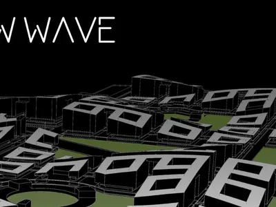
New Wave: Rethinking Barcelona's Eixample Grid as a Living Urban Ecosystem
A layered hyperblock proposal separates pedestrians from vehicles and threads continuous green infrastructure through Cerdà's iconic grid.

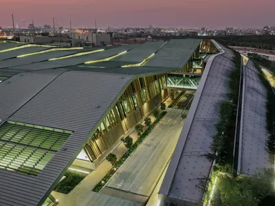
A Park Building That Wants to Be a Landscape
Omrania's Operations & Maintenance Building at King Salman Park dissolves industrial program into Riyadh's largest green infrastructure.

Mashiach Now Square: Revitalizing Urban Ground into a Green Civic Landscape
Urban square transformed into green infrastructure with paths, native planting, and community spaces, enhancing ecology, mobility, and social interaction.

Villa Qabalah: Sustainable Luxury and Community-Centered Design in Phuket
Villa Qabalah in Phuket blends sustainable luxury, rooftop greenery, mixed-use spaces, and community engagement, redefining urban living with eco-conscious design.


